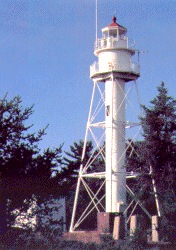
La Pointe Light

La Pointe Light

Infobox_Lighthouse


caption =
location = Long Island, Wisconsin
coordinates = coord|46|43|42|N|90|47|06|W|region:US_type:landmark
yearlit = 1896
automated = 1964
yeardeactivated =
foundation = Concrete
construction = Cast iron
shape = White, Skeletal with a central column
height = 64 ft (19.5 m)
lens = Fourth order Fresnel lens
range = 8 statute miles (13 km)
characteristic = Green, [Isophase (Equal interval), 6 sec
ARLHS = USA-423
USCG = 7-15280
The La Pointe Light is a lighthouse located on Long Island, one of the Apostle Islands, in Lake Superior in Ashland County, Wisconsin, near the city of Bayfield.

Currently owned by the National Park Service and part of the Apostle Islands National Lakeshore, it was added to the National Register of Historic Places in 1983, as reference number 83003366. Listed in the Library of Congress, Historic American Buildings Survey, WI-325 and WI-325-A. It is one of the oldest skeletal lighthouses on the Great Lakes and played an important role in transportation on Lake Superior.

A square wooden tower, constructed in 1858, was located around 3000 feet west (0.9 km) of the current light. The previous lens was moved to the Chequamegon Point Lighthouse in 1897.

External links

* [http://www.nps.gov/apis/longlite.htm NPS - La Pointe (Long Island) Light Station]
* [http://www.lighthousefriends.com/light.asp?ID=696 Lighthouse friends article]
* [http://www.cr.nps.gov/maritime/park/lapointe.htm NPS Inventory of Historic Light Stations - Wisconsin]
* [http://www.navcen.uscg.gov/pubs/LightLists/V7COMPLETE.PDF Volume 7, USCG Lightlist (PDF)]
* [http://hdl.loc.gov/loc.pnp/hhh.wi0259 Library of Congress Historic American Buildings Survey] Survey number HABS WI-325
* [http://hdl.loc.gov/loc.pnp/hhh.wi0314 Library of Congress Historic American Buildings Survey] Survey number HABS WI-325-A


Wikimedia Foundation. 2010.

Игры ⚽ Нужно решить контрольную?

Look at other dictionaries:

  • Pointe-à-Callière Museum — is the Montreal museum of archaeology and history located in Old Montreal, Quebec, Canada. It was founded in 1992 as part of celebrations to mark Montreal s 350th birthday. Set atop the city s birthplace, the Museum shows collections of artefacts …   Wikipedia

  • Pointe au Baril, Ontario — (2001 population: 505) is located on the east coast of Georgian Bay, in central Ontario, Canada (coord|45|35|44|N|80|22|29|W|type:city(505) region:CA).The community is located in the township of The Archipelago in the Parry Sound District.History …   Wikipedia

  • Pointe Saint-Charles — Église orthodoxe de Pointe Saint Charles Administration Pays …   Wikipédia en Français

  • Pointe du Hoc — (IPA2|pwε̃t dy ɔk) is a clifftop location on the coast of Normandy in northern France. It lies 4 miles (6.4 km) west of Omaha Beach, and stands on 100 ft (30 m) tall cliffs overlooking the sea. It was a point of attack by the United States Army… …   Wikipedia

  • Pointe aux Barques Light — Infobox Lighthouse caption = Pointe Aux Barques Light location = Port Hope, Michigan coordinates = coord|44|01|24|N|82|47|36|W| established = 1848 yearbuilt = 1848 yearlit = 1857 automated = 1958 yeardeactivated = construction = Brick foundation …   Wikipedia

  • Pointe shoes — Modern pointe shoes. The edge of the toe pad, which is inserted between the foot and toe box for cushioning, can be seen on the right foot. A pointe shoe is a type of shoe worn by ballet dancers when performing pointework. Pointe shoes developed… …   Wikipedia

  • Pointe du Grouin du Cou lighthouse — The Pointe du Grouin du Cou lighthouse (sometimes called the La Tranche sur Mer lighthouse) is a French lighthouse, located on the eponymous point in the southern part of the Vendée department; it guards the entrance to the Pertuis Breton on the… …   Wikipedia

  • Pointe-à-Pitre — French commune nomcommune=Pointe à Pitre mapcaption=Location of the commune (in red) within Guadeloupe time zone=UTC 4 région=Guadeloupe département=Guadeloupe ( sous préfecture ) arrondissement=Pointe à Pitre insee=97120 cp=97110 maire=Jaques… …   Wikipedia

  • Pointe-aux-Trembles — Pour les articles homonymes, voir Pointe aux Trembles (homonymie). Pointe aux Trembles Vue sur la rive du fleuve St Laurent Ad …   Wikipédia en Français

  • Pointe aux Pins — Infobox protected area | name = Pointe aux Pins nearest city = Blenheim, Ontario lat degrees = 42 lat minutes = 16 lat seconds = 33.22 lat direction = N long degrees = 81 long minutes = 51 long seconds = 26.31 long direction = WPointe aux Pins is …   Wikipedia

Share the article and excerpts

Direct link
Do a right-click on the link above
and select “Copy Link”