- Chequamegon Point Light
-
Chequamegon Point Light 
Location Long Island, Wisconsin Coordinates 46°43′42″N 90°48′34″W / 46.72833°N 90.80944°WCoordinates: 46°43′42″N 90°48′34″W / 46.72833°N 90.80944°W Year first lit 1896 Automated 1964 Deactivated 1986 Foundation Originally on a concrete pier Construction Iron Tower shape White skeletal Height 35 feet (11 m) Original lens Fourth order Fresnel lens ARLHS number USA-164[1][2] USCG number 7-15295 The Chequamegon Point Lighthouse is a lighthouse located on Long Island, one of the Apostle Islands, in Lake Superior in Ashland County, Wisconsin, near the city of Bayfield.[3]
The Chequamegon Point light was maintained by the keeper of the La Pointe Light (about a mile away) and its original lens came from their. A boardwalk connected them, so light keepers could ride bicycles between the lights.[4] It is currently owned by the National Park Service and part of the Apostle Islands National Lakeshore.
The lighthouse was moved back on to the shoreline after it was replaced by a modern D9 cylindrical tower (a "sewer pipe" with light and fog signal) constructed in 1986.[4]
In 1868 the original was established on Long Island's western end, marking the entrance to Chequamegon Bay and with it the towns of Washburn and Ashland.[4]
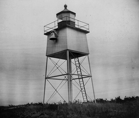
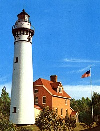
In 1896, it was replaced in 1896 by a square, white steel room sitting on steel legs. The room is topped by an octagonal lantern with a red roof. The concept echoes that of Lake Huron's Alpena Light.[4] There are also skeletal towers of various other designs in the western Great Lakes.[5]
In 1986, the Coast Guard moved the light back from the shore. It as threatened by erosion. Now pine trees have grown around it. It is no longer an active aid to navigation.[4]
Access is by walking from the dock at the LaPointe station along the beach.
References
- ^ Amateur Radio Lighthouse Society, Chequamegon Point (Lake Superior) Light ARLHS USA-164.
- ^ Amateur Radio Lighthouse Society, World List of Lights (WLOL).
- ^ "Chequamegon Lighthouse". Geographic Names Information System, U.S. Geological Survey. http://geonames.usgs.gov/pls/gnispublic/f?p=gnispq:3:::NO::P3_FID:1562978.
- ^ a b c d e Wobser, David, Chequamegon Point Light, from an article that originally appeared in Great Laker Magazine at boatnerd.com.
- ^ See, List of Tower Types, Terry Pepper, Seeing the Light.
Further reading
- Havighurst, Walter (1943) The Long Ships Passing: The Story of the Great Lakes, Macmillan Publishers.
- Merkel, James, Long Island Light, The Overlooked Light of the Apostles (March, 2000) pp. 19-21. Lighthouse Digest.
- Oleszewski, Wes, Great Lakes Lighthouses, American and Canadian: A Comprehensive Directory/Guide to Great Lakes Lighthouses, (Gwinn, Michigan: Avery Color Studios, Inc., 1998) ISBN 0-932212-98-0.
- Pepper, Terry. "Seeing the Light: Lighthouses on the western Great Lakes". http://www.terrypepper.com/lights/index.htm.
- Wright, Larry and Wright, Patricia, Great Lakes Lighthouses Encyclopedia Hardback (Erin: Boston Mills Press, 2006) ISBN 1-55046-399-3.
 USCG archive photo
External links
- Lighthouse friends article
- NPS Inventory of Historic Light Stations - Wisconsin
- Rowlett, Russ. "Lighthouses of the United States: Eastern Wisconsin". The Lighthouse Directory. University of North Carolina at Chapel Hill. http://www.unc.edu/~rowlett/lighthouse/wi.htm.
- "Historic Light Station Information and Photography: Wisconsin". United States Coast Guard Historian's Office. http://www.uscg.mil/history/weblighthouses/LHWI.asp.
- (PDF) Light List, Volume VII, Great Lakes. Light List. United States Coast Guard. http://www.navcen.uscg.gov/pdf/lightLists/LightList%20V7.pdf. - Current D9 light is listed
- Wobser, David, Chequamegon Point Light, from an article that originally appeared in Great Laker Magazine at boatnerd.com.
Lighthouses of Wisconsin See also: List of lighthouses in Wisconsin Lake Superior Apostle Islands • Ashland Harbor Breakwater • Chequamegon Point • Devils Island • Gull Island • La Pointe • Michigan Island • Outer Island • Raspberry Island • Sand Island • Wisconsin Point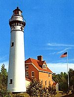
Lake Michigan Algoma Pierhead • Baileys Harbor • Baileys Harbor Range • Boyer Bluff • Cana Island • Chambers Island • Eagle Bluff • Grassy Island Range • Green Bay Harbor Entrance • Kenosha North Pier • Kenosha Southport • Kewaunee Pierhead • Kevich • Manitowoc Breakwater • Milwaukee Breakwater • Milwaukee Pierhead • North Point • Peshtigo Reef • Pilot Island • Plum Island Range • Pottawatomie • Rawley Point • Sherwood Point • Sturgeon Bay Canal • Sturgeon Bay Canal North Pierhead • Wind PointLake Winnebago Historical (lost) lights Dunlap Reef Range Front • Manitowoc Main • Manitowoc North Pierhead • Plum Island Range Front • Racine North Pierhead • Racine Reef LightCategories:- Lighthouses in Wisconsin
- Buildings and structures in Ashland County, Wisconsin
- Visitor attractions in Ashland County, Wisconsin
Wikimedia Foundation. 2010.