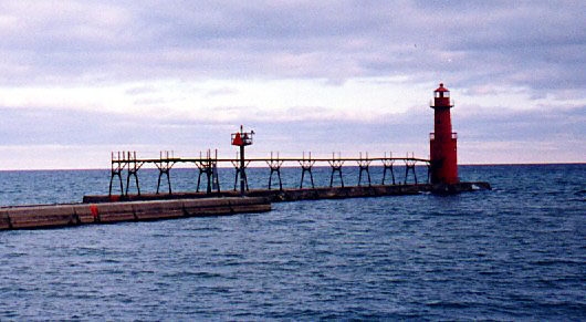
- Algoma Pierhead Light
Infobox_Lighthouse
caption =
location = Algoma,Wisconsin
coordinates = coord|44|36|25|N|87|25|46|W|region:US_type:landmark
yearlit = 1932
automated = 1973
yeardeactivated =
foundation = Pier
construction = Steel
shape = Red cylindrical tower
height = 48 feet (15 m)
lens =Fresnel lens
range = 16 statute miles (26 km)
characteristic = Red, Isophase, 6 sec. HORN: 1 blast ev 10s (1s bl). Operated from Apr. 1 to Dec. 1 and other times as required by local conditions.The Algoma Pierhead lighthouse is alighthouse located near Algoma in Kewaunee County,Wisconsin .The lighthouse was first established in 1893 as a set of
range light s. It was rebuilt in 1908 at which time it was a conical tower built of 5/16 inch steel plate, 8 feet in diameter at the base and 7 feet in diameter at the parapet. It stood 26 feet high. In 1932 it was modified again and the entire structure was raised to a height of 42 feet by placing the older tower on a new steel base 12 feet in diameter. The original lens has been replaced by a plastic lens.It is called Algoma Light and listed as number 20975 in [http://www.navcen.uscg.gov/pubs/LightLists/LightLists.htm USCG light lists] .
=External links
* [http://www.terrypepper.com/lights/michigan/algoma/algoma.htm Seeing the light]
* [http://www.unc.edu/~rowlett/lighthouse/wi.htm Lighthouse Digest, Wisconsin lighthouses, Algoma Pierhead Light, University of North Carolina.]
* [http://www.lighthousefriends.com/light.asp?ID=254 Lighthouse friends article]
* [http://www.cr.nps.gov/maritime/light/algoma.htm NPS Inventory of Historic Light Stations - Wisconsin]
* [http://www.navcen.uscg.gov/pubs/LightLists/V7COMPLETE.PDF Volume 7, USCG Lightlist (PDF)]
Wikimedia Foundation. 2010.