- Dunsden Green
-
Coordinates: 51°29′32″N 0°56′14″W / 51.4923°N 0.9372°W
Dunsden Green 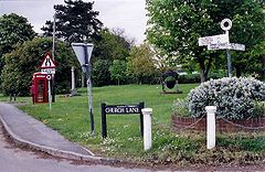
The village green at Dunsden
 Dunsden Green
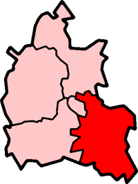
Dunsden Green shown within OxfordshireOS grid reference SU7377 Parish Eye & Dunsden District South Oxfordshire Shire county Oxfordshire Region South East Country England Sovereign state United Kingdom Post town Reading Postcode district RG4 Dialling code 0118 Police Thames Valley Fire Oxfordshire Ambulance South Central EU Parliament South East England UK Parliament Henley Website Eye & Dunsden Parish Council List of places: UK • England • Oxfordshire Dunsden Green or Dunsden is a village in the civil parish of Eye & Dunsden in South Oxfordshire, about 3 miles (4.8 km) northeast of Reading, Berkshire. Before 1866, it was part of the Oxfordshire section of Sonning civil parish.[citation needed]
Contents
History
The toponym means "valley of a man named Dyn(n)e". In 1086 the Domesday Book recorded it as Dunesdene, and a document of 1586 records it as Donsden Grene.[citation needed]
The Church of England parish church of All Saints[1] was designed by the architect John Turner and built in 1842.[2]
Nearby is the former vicarage. The future First World War poet Wilfred Owen lived from September 1911 to February 1913 when he served as a lay assistant to the parish priest, Rev. Herbert Wigan.[3]
The village school was built in 1848. It is now the village hall.[4]
In 2002 the Loddon Brewery was established in a converted 18th century brick and flint barn at Dunsden Green Farm.[5]
In November 2007 a new community orchard was established by the planting of a Blenheim Orange apple tree on the village green by Lord Phillimore, the main local landowner.[6] The orchard will be beside the village green.
See also
References
- ^ Parish Churches of Shiplake, Dunsden and Harpsden
- ^ Pevsner, Nikolaus; Sherwood, Jennifer (1974). The Buildings of England: Oxfordshire. Harmondsworth: Penguin. p. 590. ISBN 0 14 071045 0.
- ^ Wilfred Owen — The Vicarage
- ^ Eye & Dunsden Parish Council: The Village Hall
- ^ The Loddon Brewery
- ^ Eye & Dunsden Community Orchard
Image gallery
-
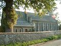
Parish church of All Saints, Dunsden.
-
The green at Dunsden Green.
External links
 Media related to Dunsden Green at Wikimedia CommonsCategories:
- Oxfordshire geography stubs
- Sonning
- Villages in Oxfordshire


Wikimedia Foundation. 2010.