- Cholsey
-
Coordinates: 51°34′26″N 1°09′04″W / 51.574°N 1.151°W
Cholsey 
St. Mary's parish church
 Cholsey
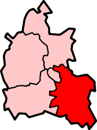
Cholsey shown within OxfordshirePopulation 3,380 (2001 census)[1] OS grid reference SU5886 - London 45 mi (72 km) Parish Cholsey District South Oxfordshire Shire county Oxfordshire Region South East Country England Sovereign state United Kingdom Post town Wallingford Postcode district OX10 Dialling code 01491 Police Thames Valley Fire Oxfordshire Ambulance South Central EU Parliament South East England UK Parliament Wantage Website Cholsey Parish Council List of places: UK • England • Oxfordshire Cholsey is a village and civil parish 2 miles (3 km) south of Wallingford, in South Oxfordshire. In 1974 it was transferred from Berkshire to the county of Oxfordshire, and from Wallingford Rural District to the district of South Oxfordshire.
The village green is known as The Forty. Winterbrook, at the north end of Cholsey parish adjoins Wallingford, and is the site of Winterbrook Bridge, which crosses the Thames.
Contents
Archaeology
A Bronze Age site has been found beside the River Thames at Whitecross Farm in the northeast of the parish.[2]
A pre-Roman road, the Icknield Way, crosses the River Thames at Cholsey.
History
The village was originally founded on an island (Ceol's Isle) in marshy ground close to the Thames. There is evidence that the House of Wessex Royal family owned land in Cholsey in the 6th and 7th century. A royal nunnery, Cholsey Abbey, was founded in the village in 986 by Queen Dowager Ælfthryth on land given by her son, King Ethelred the Unready. The nunnery is thought to have been destroyed by invading Danes in 1006 when they camped in Cholsey after setting nearby Wallingford ablaze. However, Saxon masonry still survives in the Church of England parish church of St Mary. Most of this flint and stone church was built in the 12th century.
The novelist Agatha Christie's grave is in the churchyard. She died at Winterbrook House in the parish in 1976.
In the 13th century a tithe barn was built in the village. It was, at the time, the largest aisled building in the World, being 51 feet (16 m) high, 54 feet (16 m) wide and over 300 feet (91 m) long.[3] It was demolished in 1815.
Transport
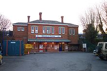 Cholsey railway station
Cholsey is served by Cholsey railway station, a calling point for First Great Western stopping services on the Great Western Main Line between Reading and Didcot.
The station was also the junction for a branch line to Wallingford, which the heritage Cholsey and Wallingford Railway now operates on Bank Holidays and some weekends.
References
- ^ "Area: Cholsey CP (Parish): Parish Headcounts". Neighbourhood Statistics. Office for National Statistics. http://neighbourhood.statistics.gov.uk/dissemination/LeadTableView.do?a=7&b=798635&c=Cholsey&d=16&e=15&g=480788&i=1001x1003x1004&o=1&m=0&r=1&s=1269206605359&enc=1&dsFamilyId=779. Retrieved 21 March 2010.
- ^ Cromarty, Barclay, Lambrick & Robinson, 2006
- ^ Samuel Lysons, Magna Britannia, Berkshire volume, page 264
Sources and further reading
- Cromarty, Anne Marie; Barclay, Alistair; Lambrick, George; Robinson, Mark (2006). Late Bronze Age Ritual at Whitecross Farm, Wallingford. Thames Valley Landscape Series. 22. Oxford: Oxford University School of Archaeology. ISBN 0947816674.
- Page, W.H.; Ditchfield, P.H., eds (1924). A History of the County of Berkshire, Volume 4. Victoria County History. pp. 296–302.
- Pevsner, Nikolaus (1966). Berkshire. The Buildings of England. Harmondsworth: Penguin Books. pp. 115–117.
External links
Categories:- Villages in Oxfordshire
- Civil parishes in Oxfordshire


Wikimedia Foundation. 2010.