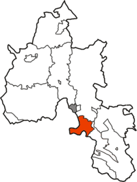
- Culham Rural District
-
Culham 
Geography Status Rural district 1901 area 12,346 acres (50.0 km2) 1931 area 12,345 acres (50.0 km2) HQ Abingdon History Created 1894 Abolished 1932 Succeeded by Bullingdon Rural District Demography 1891 population 2,692 1911 population 2,614 1931 population 2,758 Culham was a rural district in Oxfordshire, England from 1894 to 1932. It was formed under the Local Government Act 1894 from the part of the Abingdon Rural Sanitary District in the administrative county of Oxfordshire. The remainder of the sanitary district, in the administrative county of Berkshire, became Abingdon Rural District.[1] The rural district council continued to be based at Abingdon, holding meetings in the workhouse of the poor law union.[2]
Parishes
The rural district consisted of ten civil parishes:
- Burcot
- Chislehampton
- Clifton Hampden
- Culham
- Drayton St Leonard
- Marsh Baldon
- Nuneham Courtenay
- Sandford on Thames
- Stadhampton
- Toot Baldon
Abolition
Culham Rural District was abolished under a County Review Order in 1932, merging with a number of other districts to form Bullingdon Rural District.[1] Since 1974 the area has formed part of the South Oxfordshire district.
References
- ^ a b Youngs, Frederic A, Jr. (1979). Guide to the Local Administrative Units of England, Vol.I: Southern England. London: Royal Historical Society. p. 666. ISBN 0901050679.
- ^ "Culham". Kelly's Directory of Oxfordshire. Historical Directories. 1911. p. 91. http://www.historicaldirectories.org/hd/makepdf.asp?fn=E:\ZYIMAGE\DATA\HISTDIR\TIF\BC7AC4~1\0000A3YF.TIF.
Categories:- History of Oxfordshire
- Districts of England created by the Local Government Act 1894
- Rural districts of England
Wikimedia Foundation. 2010.

