- Crowmarsh Rural District
-
Crowmarsh 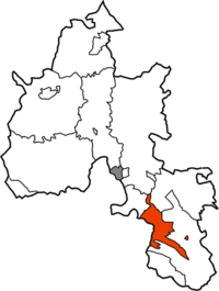
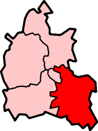
Geography Status Rural district 1901 area 20,164 acres (81.6 km2) 1931 area 20,164 acres (81.6 km2) HQ Wallingford History Created 1894 Abolished 1932 Succeeded by Bullingdon Rural District, Henley Rural District Demography 1891 population 5,150 1911 population 5,014 1931 population 5,133 Crowmarsh was a rural district in Oxfordshire, England from 1894 to 1932.
It was created under the Local Government Act 1894 from the part of the Wallingford rural sanitary district in Oxfordshire. The remainder of the sanitary district was in Berkshire and became the Wallingford Rural District. Crowmarsh Rural District continued to be administered from Wallingford, with meetings held in the workhouse in the town.[1]
The district was abolished in 1932 under a County Review Order, being split between the existing Henley Rural District and the new Bullingdon Rural District. Since 1974 the entire area has been part of the district of South Oxfordshire, which also includes Wallingford and district.[2]
Civil parishes
The district consisted of the following civil parishes:
- Benson†
- Berrick Salome†
- Crowmarsh Gifford‡
- Dorchester†
- Ewelme (this parish had a detached part which formed an exclave of the rural district) †
- Mongewell‡
- Newnham Murren‡
- Newington†
- North Stoke‡
- South Stoke‡
- Warborough†
†To Bullingdon RD in 1932
‡To Henley RD in 1932
References
- ^ "Crowmarsh Gifford". Kelly's Directory of Oxfordshire. Historical Directories. 1911. p. 90. http://www.historicaldirectories.org/hd/makepdf.asp?fn=E:\ZYIMAGE\DATA\HISTDIR\TIF\BC7AC4~1\0000A3YE.TIF.
- ^ Frederic A Youngs Jr., Guide to the Local Administrative Units of England, Volume I: Southern England, London, 1979
Categories:- Districts of England abolished by the Local Government Act 1972
- Districts of England created by the Local Government Act 1894
- History of Oxfordshire
- Local government in Oxfordshire
- Rural districts of England

Wikimedia Foundation. 2010.