Coordinates: 51°35′27″N 1°15′26″W / 51.5909°N 1.2571°W / 51.5909; -1.2571
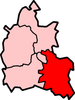
Coscote is a hamlet in the civil parish of East Hagbourne, in the Berkshire Downs 1 mile (1.6 km) south of Didcot. Coscote is now in Oxfordshire, and in 1974 was transferred from Berkshire.
Transport
Coscote is served by 6 buses a day Monday - Saturday, by the Abingdon Bus Company's Route 94, from West Hagbourne to Didcot via Blewbury.
Recent developments
Along with East Hagbourne and West Hagbourne, as of 2007, the hamlet's peace is threatened by the Great Western Park development. Plans including the extension of Didcot's ring road.
| v · South Oxfordshire |
|
| Oxfordshire • County Council elections • District Council elections • Henley County Constituency • Wantage County Constituency |
|
| Towns |
|
 |
|
| Large Villages |
|
|
Other Civil
Parishes
(Component
Villages
and Hamlets) |
Adwell • Aston Rowant • Aston Tirrold • Aston Upthorpe • Beckley and Stowood ( Beckley, Stowood) • Berrick Salome ( Berrick Prior, Roke, Rokemarsh) • Binfield Heath • Bix and Assendon ( Bix, Bix Bottom, Lower Assendon, Middle Assendon) • Brightwell Baldwin • Britwell Salome • Checkendon • Clifton Hampden (Burcot) • Crowell • Cuddesdon and Denton ( Cuddesdon, Denton) • Culham • Cuxham with Easington ( Cuxham, Easington) • Dorchester • Drayton St. Leonard • East Hagbourne ( Coscote) • Elsfield • Eye and Dunsden ( Sonning Eye, Dunsden Green, Playhatch) • Forest Hill with Shotover (Forest Hill, Shotover) • Goring Heath (Whitchurch Hill, Cray's Pond) • Great Haseley (Latchford, Little Haseley, North Weston, Rycote) • Harpsden • Highmoor (Satwell) • Holton • Ipsden • Kidmore End ( Gallowstree Common) • Lewknor ( Postcombe, South Weston) • Little Milton • Little Wittenham • Long Wittenham • Mapledurham ( Trench Green, Chazey Heath) • Marsh Baldon ( Baldon Row) • Moulsford • Nettlebed • Newington ( Great Holcombe) • North Moreton • Nuffield • Nuneham Courtenay • Pishill with Stonor ( Pishill, Stonor, Maidensgrove, Russell's Water) • Pyrton (Clare, Standhill) • Rotherfield Greys • Rotherfield Peppard • Shirburn • South Moreton ( Fulscot) • South Stoke ( Littlestoke) • Stadhampton ( Chiselhampton, Brookhampton, Ascott) • Stanton St. John (Woodperry) • Stoke Row • Stoke Talmage • Swyncombe • Sydenham (Kingston Stert) • Tetsworth • Tiddington-with-Albury (Tiddington, Albury) • Toot Baldon • Towersey • Warborough ( Shillingford) • Waterstock • West Hagbourne • Whitchurch-on-Thames • Woodeaton • Waterperry with Thomley ( Waterperry, Thomley) • Wheatfield • Wilcote
|
|
Former Districts
and Boroughs |
|
|
Former
Constituencies |
|
|
| List of Parliamentary constituencies in Oxfordshire • List of places in Oxfordshire • List of civil parishes in Oxfordshire |
|

 Coscote

