- Old Santa Susana Stage Road
-
Old Santa Susana Stage Road
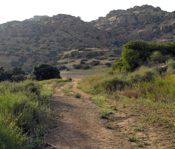 A portion of the Old Santa Susana Stage Road
Nearest city: Chatsworth, California Built: 1861 Architectural style: None Governing body: California Department of Parks and Recreation NRHP Reference#: 74000517 Added to NRHP: January 10, 1974[1] The Old Santa Susana Stage Road or Santa Susana Wagon Road is a route taken by early travellers between the San Fernando Valley and Simi Valley near Chatsworth, California via the Santa Susana Pass. The main route climbs through what is now the Santa Susana Pass State Historic Park, with a branch in Chatsworth Park South.
It was an important artery linking the Los Angeles Basin and inland Ventura county, and was part of the main route for travel by stagecoach between Los Angeles and San Francisco from 1861 until the opening of rail traffic between the cities in 1876. The Old Santa Susana Stage Road is listed on the National Register of Historic Places. Part of the stage road is also a Historic-Cultural Monument of Ventura County and of the City of Los Angeles under the name Old Stagecoach Trail.
Contents
History
In 1859, the California Legislature appropriated $15,000 for improving an old wagon road through the Santa Susana Pass. Additional funding was provided by the Counties of Los Angeles and Santa Barbara. The outbreak of the American Civil War in 1861 disrupted mail service along the Butterfield Overland Mail's southern stagecoach route from St. Louis, Missouri via El Paso, Fort Yuma and Los Angeles and on to San Francisco via the Tejon Pass, which had begun its run in 1858. To compensate, the government contracted the Butterfield Company to carry mail between Los Angeles and San Francisco via the new wagon road over the Santa Susana Pass. The first overland mail stage run through the pass took place on April 6, 1861.[2][3][4] The new route diverged from the Tejon Pass route at the north end of the Cahuenga Pass, following the old coast road (El camino Viejo, the former El Camino Real to San Buenaventura (Ventura) and Santa Barbara) as far as the Rancho Los Encinos before striking northwest across the San Fernando Valley toward the Santa Susana Pass.[2][5]
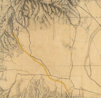 1880 manuscript map of the western San Fernando Valley, with the stage route from Rancho Los Encinos to Santa Susana Pass (upper left) highlighted.
The precipitous portion of the route on the San Fernando Valley side was called the Devil's Slide; horses were usually blindfolded and chains were used to augment brakes on the steep descent. Passengers debarked and walked.[2]
The Santa Susana Pass Road continued in use as an alternative to the route along El Camino Viejo from 1861 to 1875, replacing the older road as the main route between Los Angeles and San Francisco. William E. Lovett acquired the mail contract in 1867 and carried mail and passengers via the Santa Susana Pass and between Los Angeles and San Diego. In 1876, the Southern Pacific Railroad opened a tunnel through the Newhall Pass, enabling rail connections from Los Angeles north to San Francisco, and rail travel soon replaced travel by stagecoach between Los Angeles and San Francisco. From this time the stagecoach traffic to Santa Barbara once again used the coast route, and the Santa Susana Pass road was relegated to local traffic.[2]
A new wagon route bypassing the deteriorating Devil's Slide was opened in 1895. Initially called El Camino Nuevo (the New Road), it was later named the Chatsworth Grade Road, which continued in use until Santa Susana Pass Road (now Old Santa Susana Pass Road) was built in 1917.[2]
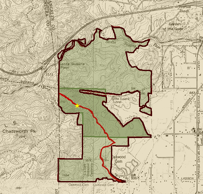
 Map of the Stage Road NRHP property (shaded) within Santa Susana State Historic Park. The stage road is shown in red, and a star marks the location of the 1937 commemorative plaque at the base of the Devil's Slide.
Hikers in the Santa Susana Pass State Historic Park can still see the deep ruts made by the wagons on the 'Devil's Slide' section. A plaque was embedded into the sandstone rock by the Native Daughters of the Golden West in 1937, commemorating the Old Santa Susana Stage Road.[2][3]
A branch of the Santa Susana Pass stagecoach road was designated as Los Angeles Historic-Cultural Monument #92, 'The Old Stagecoach Trail', by the City of Los Angeles on January 5, 1972. A 174-acre (0.70 km2) parcel containing the stagecoach road was listed on the National Register of Historic Places in 1974. The stage route was also declared Ventura County Historical Landmark #104 on October 24, 1986.[1][2][6]
See also
- History of the San Fernando Valley to 1915
- Old Santa Susana Stage Road Historic-Cultural Monument
- Santa Susana Pass
- Santa Susana Pass State Historic Park
- Spahn Movie Ranch
References
- ^ a b "National Register Information System". National Register of Historic Places. National Park Service. 2008-04-15. http://nrhp.focus.nps.gov/natreg/docs/All_Data.html.
- ^ a b c d e f g Bevill, Arthur D. (2007). Santa Susana Pass State Historic Park Cultural Resource Survey Historic Overview. http://www.parks.ca.gov/pages/980/files/sspshp%20historic%20resources.pdf.
- ^ a b Old Stagecoach Trail at www.trails.com
- ^ Link, Tom: Universal City - North Hollywood, a Centenniel Portrait, Windsor Publications, 1991, ISBN 0897813936, p. 25
- ^ The stagecoach routes can clearly be seen on period maps.
- ^ California Department of Parks and Recreation (2007). Santa Susana Pass State Historic Park Preliminary General Plan/Draft EIR. http://www.parks.ca.gov/pages/21299/files/chapter%201%20introduction(1).pdf.
External links
- California State Parks Dept. - Santa Susana Pass State Historic Park
- LAMountains.com - Santa Susana Pass State Historic Park
- City of Los Angeles Department of Recreation and Parks - Chatsworth Park South
- State Parks - Simi Hills Ethnohistory
History of California to 1899 Precontact · First explorations · Later explorations · Spanish colonization · Russian colonization · Mexican rule · California Trail · Mexican-American War · U.S. rule · Gold Rush · Civil War
since 1900 By topic By city Los Angeles · Riverside · Sacramento · San Bernardino · San Diego · San Francisco · San Jose
U.S. National Register of Historic Places Topics Lists by states Alabama • Alaska • Arizona • Arkansas • California • Colorado • Connecticut • Delaware • Florida • Georgia • Hawaii • Idaho • Illinois • Indiana • Iowa • Kansas • Kentucky • Louisiana • Maine • Maryland • Massachusetts • Michigan • Minnesota • Mississippi • Missouri • Montana • Nebraska • Nevada • New Hampshire • New Jersey • New Mexico • New York • North Carolina • North Dakota • Ohio • Oklahoma • Oregon • Pennsylvania • Rhode Island • South Carolina • South Dakota • Tennessee • Texas • Utah • Vermont • Virginia • Washington • West Virginia • Wisconsin • WyomingLists by territories Lists by associated states Other  Category:National Register of Historic Places •
  Portal:National Register of Historic Places
Los Angeles Historic-Cultural Monument Lists Downtown Los Angeles • East and Northeast Sides • Harbor Area • Hollywood • San Fernando Valley •
Silver Lake, Angelino Heights and Echo Park • South Los Angeles • Westside • Wilshire and Westlake AreasCategories:- History of the San Fernando Valley
- Historic trails and roads in the United States
- Historic trails and roads in California
- Trails and roads in the American Old West
- San Fernando Valley
- Infrastructure-related listings on the National Register of Historic Places
- California Historical Landmarks
- Landmarks in California
- California State Historic Parks
- Open air museums in California
- Los Angeles Historic-Cultural Monuments
- National Register of Historic Places in the San Fernando Valley
- Parks in Los Angeles, California
- Santa Susana Mountains
- National Register of Historic Places in Los Angeles, California
- Roads on the National Register of Historic Places in California


Wikimedia Foundation. 2010.