- Rancho Los Encinos
Infobox_nrhp | name =Rancho El Encino
nrhp_type =
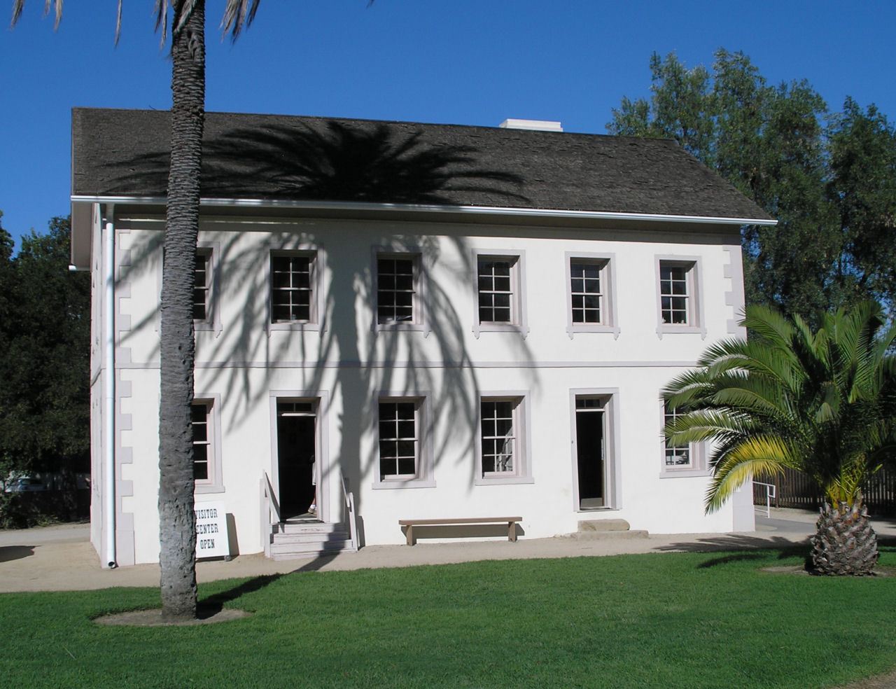
caption = The Garnier building at Rancho Los Encinos, recently restored after damage from the 1994Northridge earthquake , is now the Visitor Center.
location= Encino, California
lat_degrees = 34
lat_minutes = 9
lat_seconds = 35.97
lat_direction = N
long_degrees = 118
long_minutes = 28
long_seconds = 22
long_direction = W
locmapin = California
area =
built =1845
architect=
architecture= No Style Listed
added =February 24 ,1971
governing_body = State
refnum=71000142cite web|url=http://www.nr.nps.gov/|title=National Register Information System|date=2007-01-23|work=National Register of Historic Places|publisher=National Park Service]Rancho Los Encinos (also Rancho El Encino and Rancho Encino) was a Spanish grazing concession, [Beck, Warren A. and Ynez D. Haase, "Historical Atlas of California", p. 37]
cattle andsheep ranch ,stagecoach stop,wheat farm , andreal estate subdivision in theSan Fernando Valley ofCalifornia nearLos Angeles . The heart of the property, where the 19th centuryadobe andlimestone farmhouses still stand near a perennialwarm spring just off Ventura Boulevard (the former El Camino Real), is now theLos Encinos State Historic Park in Encino.History
Origins
The name of the rancho derives from the original designation of the Valley by the
Portola expedition of 1769: "El Valle de Santa Catalina de Bononia de los Encinos", [Bearchell, Charles, and Larry D. Fried: "The San Fernando Valley Then and Now", p. 93] "encino" being the Spanish name for the evergreenCoast Live Oak s which still grow on the property.Francisco Reyes , "alcalde " of Los Angeles from 1793-1795, established the original Rancho Encino in the northern San Fernando Valley. In or around 1797 Reyes ceded this land to theRoman Catholic Church to be the site of Mission San Fernando, and relocated his Rancho Encino to one square league (4,460 acres) of land in the southern valley adjacent to El Camino Real. [Bearchell and Fried, p. 28, 68-69, 93-95]Reyes was accused of mistreating the Indians who worked his rancho, and in 1845 Governor
Pio Pico re-granted the property to three of the workers, recorded as Ramon, Francisco, and Roque, who raised cattle and corn.In 1849, Don Vicente de la Osa, the original owner of the nearby
Rancho Providencia , acquired the Indian's interests in the property [Bearchell and Fried, p. 94-96] . He built a 9-room adobe farmhouse that still stands near the spring in 1849-1850. He took formal title to the Rancho in under California law in 1851 [Kielbasa, "Historic Adobes of Los Angeles County", p. 34.]Boom and bust
The
California Gold Rush of 1849 created a near-insatiable demand for beef, which was raised on the ranchos of southern California, including Rancho Los Encinos, and driven on the hoof to northern markets serving the gold fields. But the boom market in Southern California began to decline as early as 1855 as it became profitable to drive cattle and sheep to California from themidwest andTexas , and thedrought of 1856 increased the pressure on the ranchos. [Cleland, Robert Glass: "The Cattle on a Thousand Hills: Southern California, 1850-1870"]The De La Osa rancho was a popular stopping point for travelers, who could expect hospitality at the ranch house. The
Butterfield Overland Mail stagecoach route betweenSt. Louis, Missouri andSan Francisco, California viaFort Yuma andLos Angeles made its first run in the fall of 1858. [Link, Tom: "Universal City - North Hollywood, a Centenniel Portrait", p. 25] The new stagecoach road diverged from the old road (the former El Camino Real) at Rancho Los Encinos and headed for Santa Barbara via theSanta Susana Pass . [The stagecoach routes can clearly be seen on period maps; see the Map Gallery.]With the cattle market in collapse and besieged by mounting debts, in 1859 De la Osa converted his house into a roadside inn and began to charge patrons for his legendary "
Californio " hospitality. [Kielbasa, p. 35] Don Vicente died in 1861, and his widow Rita sold the property to James Thompson in 1867 [Kielbasa, p. 35] , who raised sheep on the rancho for two years. Thompson in turn sold the property to two Basque brothers, Eugene and Phillipe Garnier, in 1869. Eugene Garnier built a two-story limestone farmhouse similar to the former family home inFrance , [a picture of the French house can be seen in the Vistor Center] and a brick-lined pool shaped like a Spanish guitar. The Garniers also raised sheep on the property, and were known for the fine quality of their fleece, but they in turn became overextended and lost the property to foreclosure in 1878. [Bearchell and Fried, p. 94-96]The property changed hands three times in the next twenty years, eventually being acquired entire by Domingo Amestoy in 1889. The Amestoy family lived on the property until 1945, selling off convert|1170|acre|km2|0 of land in 1916 that would become the community of Encino, and further subdividing the ranchlands thereafter.
The last remaining parcel including the historic buildings and the spring was acquired by the State of California in 1949.
The park
All of the historic buildings in the park were heavily damaged in the 1994
Northridge earthquake . The De la Osa adobe and the Garnier building have been repaired, with the Garnier building now serving as a visitor center with historic photographs and exhibits of the rancho's past. The 1902 double-roofed food-storage buildings built for the Amestoys still show signs of the earthquake and are used for Park storage.The park is located at 16756 Moorpark St., Encino, California, 91436-1068, and is open to the public 10 AM to 5 PM, Wednesday through Sunday. There is a second entrance on Ventura Boulevard.
Map gallery
ee also
*
Californio
*El Camino Real
*History of Los Angeles, California
*History of California
*Ranchos of California
*Spanish missions in California
*List of Registered Historic Places in Los Angeles Notes
External links
* [http://historicparks.org/ History Resource Centre at Los Encinos State Historic Park]
* [http://www.lahacal.org/enchist.html History of Rancho Los Encinos]
* [http://www.laokay.com/halac/RanchoLosEncinos.htm Another History of Rancho Los Encinos]
* [http://www.nps.gov/history/nr/travel/ca/ca15.htm Rancho El Encino, an NRHP Travel Itinerary] , at National Park ServiceReferences
*Bearchell, Charles, and Larry D. Fried: "The San Fernando Valley Then and Now", Windsor Publications, 1988, ISBN 089812859
*Beck, Warren A. and Ynez D. Haase, "Historical Atlas of California", University of Oklahoma Press, 1974 (first edition), ISBN 0806112123
*Cleland, Robert Glass: "The Cattle on a Thousand Hills: Southern California, 1850-1880", Huntington Library, 1941; University of California Press, ISBN 978-0-87328-097-6; online at [http://www.questia.com/PM.qst?a=o&d=91642263#] .
*Kielbasa, John, "Historic Adobes of Los Angeles County", Dorrance Publishing, Pittsburgh, 1991, ISBN 9780805941722; online at [http://www.laokay.com/halac/]
*Link, Tom: "Universal City - North Hollywood, a Centenniel Portrait", Windsor Publications, 1991, ISBN 0897813936
*Roderick, Kevin: "The San Fernando Valley: America's Suburb", Los Angeles Times Books, 2001, ISBN 188379255x]
Wikimedia Foundation. 2010.