- Northridge, Los Angeles
-
Northridge — Neighborhood of Los Angeles — Location within Los Angeles/San Fernando Valley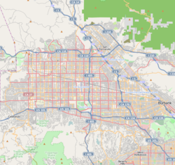
 Northridge
Coordinates: 34°13′41″N 118°32′09″W / 34.22806°N 118.53583°W Country United States State California County Los Angeles City Los Angeles Elevation 797 ft (242 m) Population (2000)[1] – Total 68,469 Time zone PST (UTC-8) – Summer (DST) PDT (UTC-7) ZIP code 91324, 91325 Area code(s) 818 Northridge is a community located in the San Fernando Valley region of the City of Los Angeles, California, United States.
The 1994 Northridge earthquake is named for the place based on early estimates of the location of the quake's epicenter; however, further refinements showed it to be technically in neighboring Reseda. The area was also heavily damaged in the 1971 San Fernando earthquake.
In 1994, the Northridge Little League Baseball team won the United States Little League Championship game, but lost the World Series game to the international team from Zulia-Maracaibo, Venezuela.
The U.S. Metric Association is based in Northridge.
Contents
Location and geography
 Reseda Blvd. Shopping District at Gresham St.
Northridge is 17 square miles (44 km2) in area and is approximately 807 feet (246 m) above sea level. Located in the northwest part of the San Fernando Valley, adjacent neighborhoods with Northridge include Granada Hills, Chatsworth, North Hills, Reseda, Porter Ranch, and Winnetka. Major streets in the area include Roscoe Boulevard, Devonshire Street, Nordhoff Street, Corbin Avenue, Tampa Avenue, and Reseda Boulevard. The community is partially bounded by the Santa Susana Mountains. The Ronald Reagan Freeway (State Route 118) runs along the northern edge of Northridge, and provides access to the rest of the Los Angeles area freeway system. The area code is 818 and zip codes are 91324 through 91330.
History
The area now called Northridge was first inhabited about 2,000 years ago by the Native American Gabrielino (or Tongva) people. Totonga was their tribal village and where Northridge eventually became located.[2] The Gabrielino-Tongva people, who lived in dome-shaped houses, are sometimes referred to as the "people of the earth."[3] They spoke a Takic Uto-Aztecan (Shoshonean) language.[4]
It wasn't until 1769 when the area known as Northridge was descriptively first reported by Father Juan Crespi, the prolific diarist who accompanied the exploration party of Spanish explorer Gaspar de Portolà on its arduous trek through California, including the Sepulveda Pass leading to the San Fernando Valley. Having traversed more than their share of dry and arid land, the discovery of water, wherever it was, merited rejoicing. And so it was with Zelzah, an unexpected oasis and one of the meeting places of the Gabrielino Indians, native to the area.[5] The explorers bathed and rested at the watering hole, fed by underground streams which still run deep beneath the intersection of Parthenia Street and Reseda Boulevard.[6]
By 1797, the Mission San Fernando Rey de España became established nearby and served as a catalyst to change the native population, which inhabited the area around Northridge for centuries. The Gabrielino Indians ended their nomadic freedom when they were pressed into service by the Mission, or fled to escape slave-labor conditions.
When American and naval military forces decided to occupy California in the late-1840s, representatives of the Mexican Governor Pio Pico broke with the tradition of "granting" land and, instead, sold it, without the usual area limitations to Eulogio de Celis, a native of Spain. By 1850, de Celis was listed in the Los Angeles Census as an agriculturist, 42 years old, and the owner of a real estate worth $20,000.[7] He returned to Spain in 1853, and he was to never return. He had, however, appointed Edward Fischer as his attorney to handle his affairs in America. After his death in Spain in 1869, de Celis' widow and children returned to California and his eldest son, Eulogio, was appointed administrator of his estate. Although de Celis' claim had been filed in October 1852, two years after California had been admitted into the Union as a state, it was not until Jan. 8, 1873 that a formal U.S. survey showed the Rancho Ex-Mission de San Fernando area as 116,858 acres (472.91 km2), the largest area of any single grant in California.
A few years later, the land was split up. The heirs of Eulogio de Celis sold the northernly half - 56,000 acres (230 km2) - to Senator George K. Porter, who had called it the "Valley of the Cumberland" and Senator Charles Maclay, who exclaimed: "This is the Garden of Eden." Porter was interested in ranching; Maclay in subdivision and colonization. Francis Marion ("Bud") Wright, an Iowa farm boy who migrated to California as a young man, became a ranch hand for Senator Porter and later co-developer of the 1,100-acre (4.5 km2) Hawk Ranch, which is now Northridge land.[8] Wright continued to farm the land with Colonel Henry Hubbard from 1887 until 1910, when it was sold for subdivision to the Valley Farms Company. Before the first small farm homes had been sold, Bud Wright's wife, Emily Vose Wright, a deeply religious woman, had christened the development Zelzah, a Biblical name for oasis, or "watering place in the desert." And "Zelzah" station it was, a Southern Pacific depot town at the Henry Hubbard & "Bud" Wright Hawk Ranch north of Los Angeles. The "Zelzah" name would stick until 1929.
Shortly after the Los Angeles City Aqueduct opened in 1913, Henry Hubbard became a member of Aqueduct Board. The following year Zelzah Grammar School opened and citizens formally voted for annexation to the City of Los Angeles and Owens River water rights in 1915. William Mulholland, engineer of the mammoth project, lived nearby and maintained one of many large rancho tracts remaining from the Spanish, Mexican and Californio land grant days.
Zelzah Acres became the name of one of those early housing tracts carved from the former enormous Rancho Ex-Mission San Fernando lands joining nearby towns of Chatsworth Park, Lankershim, Owensmouth, San Fernando and Van Nuys. Through the 1920s, Zelzah grew up, linked to Los Angeles by annexation, water, city government taxes, and transportation. A group of citizens joined forces and on July 1, 1929, christened this post office and train depot North Los Angeles, a name they considered more suitable and more memorable.
At the suggestion of Carl Dentzel, a local resident and director of the Southwest Museum in Los Angeles, North Los Angeles became "Northridge Village" and was promptly shortened to Northridge. The sign on the depot was changed again and the new name became permanently affixed, amid cheers from the crowd, on Oct. 1, 1938.[8]
In the mid-1940s, Devonshire Downs opened its doors at Devonshire and Zelzah boulevards in Northridge. It featured horse racing, carnivals and other activities. In 1948, the state bought the 40-acre (160,000 m2) facility and used it for the San Fernando Valley Fair for the next three decades. Ronald Reagan would later visit Devonshire Downs for a political rally when he was running for his first term as President of the United States of America.
In 1951, a local reporter reported that Northridge's population had reached 5,500 residents, an increase of 1,000 people from 1950. In addition, it was around this time Reseda Boulevard had been paved for its full width and become the main business street of boulevard proportions. The need also arose for Northridge to accommodate the new population, so in 1954 the first middle school opened in the rapidly growing town. Northridge Middle School opened with 1,000 students who had been brought all the way from Fulton Middle School in Van Nuys.[9]
The 1960s saw a period of rapid growth in Northridge with new housing develops and freeways bringing in new families from around the country. The Valley's first freeway, the Ventura, opened to traffic in April 1960, giving motorists what was then thought to be uninterrupted passage through the Valley from the Hollywood Freeway at Cahuenga Pass to and beyond Calabasas.
By the 1970s, Northridge steadily metamorphosed into a thriving modern community it is today. Fed by industrial parks, a new shopping center, paved roads, and an educated population, Northridge attracted new employers. By 1975, the population had zoomed to 86,686, nearly 2,000 more than official 1974 projections. The Northridge Fashion Center, built at a cost of $60 million and located at Tampa and Nordhoff, opened in 1971 with Bullock's, Sears, The Broadway, and JC Penney's as anchor tenants. The mall suffered serious damage in the 1971 Sylmar Earthquake, as well as the more devastating 1994 Northridge Earthquake.
Entertainment
During the 1930s and 1940s, when the film industry spent thousands of dollars building stars and making movies on location, Northridge became a residential magnet for celebrities and horse lovers. Its spacious fertile lands were not only investments for these stars, they were relatively isolated from the hassle that was Hollywood for these fan-plagued people, some of whom genuinely wanted to live private lives away from Tinseltown.
Clark Gable and Carole Lombard once owned a ranch where Devonshire and Etiwanda are today. In its place is the Devonshire Police Station, the LAPD Division that handles the Northridge area. Marian and Bette Hutton were the early owners of what is now Northridge Park.
Silent star Janet Gaynor and her costume-designer husband Adrian were the first owners of a spacious estate in Northridge, which was later sold to Barbara Stanwyck and Robert Taylor. Later, actor Jack Oakie owned the property and lived on it. The Oakie house was set for the wrecking ball, but in 2010 the city agreed to buy the Tudor-style stone landmark and its 10-acre (40,000 m2) ranch estate.[10]
Also, Mrs. Zeppo Marx and Barbara Stanwyck started Marwyck Ranch as a horsebreeding farm. In 1942, it was purchased by R.H. Ryan, who converted it into Northridge Farms, a nationally recognized horse breeding farm. For years, Northridge was known as the "Horse Capital of the West" with regular Sunday horse shows, annual stampedes, and country fairs.[10]
Over the years, Northridge has been a popular place for the film and television business to shoot location productions due to its close proximity to the major studios. The movie "Legally Blonde 2" (2003) filmed scenes on the California State University, Northridge campus as did "Superbad" (2007). Elliot's neighborhood in "ET: The Extra-Terrestrial" (1982) was set in a Northridge neighborhood, and a chase scene filmed in the Porter Ranch area. Several of the actors and extras from the "Bad News Bears" (1976) were from Northridge but the field where they played is in Mason Park on Mason Avenue in Chatsworth.
One of the music industry's biggest festivals in the Valley was held in Northridge. The Fantasy Faire & Magic Festival was held at Devonshire Downs (sometimes known as Devonshire Meadows) in 1967, featuring music acts such as The Doors, Jefferson Airplane, Country Joe & the Fish, The Grassroots, Canned Heat, and Iron Butterfly.[11]
Demographics
As of the 2000 census, and according to the Los Angeles Almanac there were 68,469 people residing in 24,172 households in Northridge. The racial makeup of the neighborhood was 78.14% White, 4.89% Asian, 0.16% Pacific Islander, 2.45% African American, 0.47% Native American, 11.48% from other races, and 5.41% from two or more races. 24.77% of the population were Hispanic of any race.
Median household income in 2000 was $60,108.
In 2009, the Los Angeles Times's "Mapping L.A." project supplied these Northridge neighborhood statistics: population: 57,561; median household income: $67,906.[12]
Economy
Agriculture, mostly citrus, corn, wheat, apricots, tomatoes and beans, was the main industry in Northridge until the early 1940s. The area also had a thriving livestock trade in cattle and chicken ranches. Northridge Hospital is located where there was once bean and tomato fields. The Northridge Fashion Center sits on what was once orange groves, and much of what is now the university was farmland.
Orange groves starting making way for housing developments in the 1950s, and farmhouses soon were replaced by rows of houses. A portion of the CSUN campus continues to have one of the last remaining orange groves, which was planted in the roaring 1920s. Some residential yards also have the original trees still growing oranges.
By the 1980s, CSUN was the largest employer in Northridge with more than 3,000 employees. Other major employers were the Northridge Fashion Center and the Northridge Hospital. During the 1990s, several major home lenders, such as Countrywide and Washington Mutual, began opening service facilities in Northridge. But the housing downturn resulted in those jobs being eliminated.
In 2000, insulin pump maker MiniMed announced plans to open a facility in Northridge as part of a collaboration with CSUN to build a biotechnology center. MiniMed located on a 65-acre (260,000 m2) parcel of land once known as Devonshire Downs. The property, now referred to as North Campus, is owned by CSUN. MiniMed's initial plans called for locating 4,5000 workers at the Northridge site.[13] In 2001, Minnesota-based Medtronic Inc. completed the $3.7 billion acquisition of MiniMed.
By 2011, MiniMed's new owner decided to downsize the Northridge facility and relocate 300 customer service positions to Texas. Medtronic also announced the layoff of more than 400 workers at the Northridge offices. Today, about 1,800 employees continue to work at the MiniMed complex, located at Devonshire Street and Zelzah Avenue. The division is now known as Medtronic Diabetes, and the Northridge operations focus on research and development, as well as manufacturing.[14]
Points of interest
 Faith Bible Church, built in 1917
- CSUN Botanic Garden
- California State University, Northridge – CSUN.
- Donald E. Bianchi Planetarium at CSUN
- Faith Bible Church, Northridge, California, built in 1917, is the oldest church in Northridge
- Northridge United Methodist Church, Northridge, California, dating back to 1924, was first known as the Community Methodist Episcopal Church of Zelzah.
- Northridge Fashion Center, Regional shopping mall.
- Northridge Hospital Medical Center
- Studio 606 West, the recording studio of rock band Foo Fighters
Government and infrastructure
Local government
 Northridge Hospital Medical Center
Los Angeles Fire Department Station 70 (Northridge) and Station 103 (Northridge/CSUN) serve the community.
Los Angeles Police Department operates two police stations that serve Northridge:[15]
- Devonshire Community Police Station serves residents north of Roscoe Boulevard.[16]
- West Valley Community Police Station serves residents south of Roscoe Boulevard.[17]
County, state, and federal representation
The Los Angeles County Department of Health Services operates the Pacoima Health Center in Pacoima, serving Northridge.[18]
The United States Postal Service Northridge Post Office is located at 9534 Reseda Boulevard.[19]
The U.S. Census Bureau operates the Los Angeles Regional Census Center in Chatsworth, adjacent to Northridge.[20][21]
Education
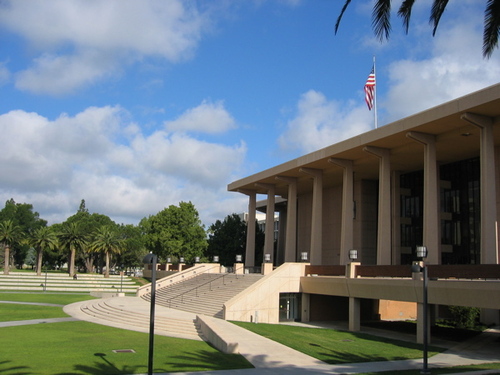
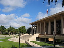 California State University, Northridge (CSUN).
Children attend public schools in the Los Angeles Unified School District.
Public middle schools include Alfred B. Nobel Middle School, Oliver Wendell Holmes International Middle School, Northridge Middle School, and William Mulholland Middle School.
Public high schools serving Northridge include Northridge Academy High School in Northridge, Monroe High School in North Hills, Birmingham High School in Van Nuys, Reseda High School and Grover Cleveland High School in Reseda, John F. Kennedy High School in Granada Hills, various LAUSD magnet schools, and Granada Hills Charter High School.
In 1962, Nobel Junior High School in Northridge became the first air-conditioned school in the Los Angeles school district.[22]
The area is also served by several private and parochial schools, including Chatsworth Hills Academy, L.A. Baptist, Our Lady of Lourdes, St Genevieve, and Chaminade.
Community colleges that serve the area include Los Angeles Valley College, Pierce College, and Los Angeles Mission College. They are part of the nine campus Los Angeles Community College District.
West Valley Occupational Center provides learning opportunities and employment training to adults and in-and out-of-school youth.
California State University, Northridge, part of the CSU system, offers bachelors and masters degrees in a number of disciplines. The school is a major producer of K12 teachers in the region and the nation as a whole. CSUN also boasts a leading engineering, business, and film program.
Like Northridge itself, which emerged from a trio of community names to its present day entity, CSUN had its beginnings as a college on Nordhoff Street and Etiwanda Avenue and official opened in 1956 as "San Fernando Valley Campus of Los Angeles State College of Applied Arts and Sciences." It was a tough name to cope with, so two years later in 1958 it separated from its parent and became "San Fernando Valley State College." By the early 1970s, however, this institution became known as "California State University, Northridge." By fall of 2006, CSUN had reached enrollment surpassing 34,500 students.
A 2004 study revealed that CSUN is a major contributor to the local economy: between $663 million and $686 million annually. Additionally, CSUN employs 5,800 people directly through the university and adds another 5,700 to 6,000 jobs into the local economy.[23]
Parks and recreation
The Northridge Recreation Center is located in Northridge. It has an indoor gymnasium, without weights, which may also be used as an auditorium. Its capacity is 400. Doc Green is the commissioner of the youth sports leagues at Northridge Recreation Center. The park also has barbecue pits, a lighted baseball diamond, lighted indoor basketball courts, lighted outdoor basketball courts, a children's play area, a community room, picnic tables, a lighted soccer (football) field, and lighted tennis courts.[24] The Northridge Pool, on the recreation center grounds, is an outdoor heated seasonal pool.[24][25] Northridge Park is also home to the Northridge Knights football, Mascot, and Cheer youth teams. These teams are members of the non-profit Northridge Athletic Club, which has provided children ages 6 – 14 and parents the opportunity to participate in local organized sports for over 40 years. In addition, the park also offers young children and teens summer camp programs which include outdoor athletic, art, and swimming activities. Campers take part in weekly field trips to places like Six Flags Magic Mountain, Disneyland, Los Angeles Zoo, Zuma Beach, and Universal Studios.
Dearborn Park is located in Northridge. The unstaffed, unlocked park has lighted outdoor basketball courts, a children's play area, picnic tables, and lighted tennis courts.[26] Vanalden Park, an unstaffed pocket park, has a horseshoe pit, a jogging path, and picnic tables.[27]
Hospital
The idea for a medical center in Northridge actually dates back to the late 1940s, when Dr. Frederick Gruneck conceived of the hospital. Long before groundbreaking, the Northridge Hospital Development Association had carefully plotted out precisely what was to be included in the $30 million program for construction of Northridge Hospital and Medical Center. This master plan, initiated in 1955, started out as a 49-bed facility with a one-room emergency room.
Today, Northridge Hospital Medical Center consists of a 411-bed hospital and serves 2 million residents of the Valley. The hospital is one of only two facilities in the Valley certified as a trauma center for treating life-threatening injuries. During the 1994 earthquake, the hospital remained open and treated over 1,000 patients that came to the facility during the first few days following the 6.7 magnitude quake.[28] Northridge Hospital, a non-profit medical facility, is operated by Catholic Healthcare West.
Famous residents
- Patty Andrews, The Andrews Sisters
- Nancy Cartwright, voice of Bart Simpson
- Jack Cassel, pitcher for the Houston Astros
- Matt Cassel, quarterback for the Kansas City Chiefs
- Jarron Collins, Utah Jazz center (went to school at Sierra Canyon in Chatsworth)
- Jason Collins, Memphis Grizzlies center (went to school at Sierra Canyon in Chatsworth)
- Jim Davis, actor on Dallas
- Lori Beth Denberg, actress, (cheerleader in Dodgeball: A True Underdog Story & cast member in All That)
- David Draiman, lead singer of the band Disturbed (moved to Austin in 2009)
- Jackie Earle Haley, actor (Bad News Bears, Watchmen)
- Jenilee Harrison, actress on Three's Company
- Mike Houghton, guard for the Buffalo Bills
- Tyler Patrick Jones, actor
- Ryan Kalish, outfielder for the Boston Red Sox (born in Northridge, but grew up in New Jersey)
- Josh Klinghoffer, musician
- John H. Meier, former business adviser to Howard Hughes, involved with Watergate[29]
- Alvy Moore, actor (Green Acres)
- Alphonse Mouzon, jazz musician, composer
- Jeffrey Osborne, musician
- Debbi Peterson, rock band The Bangles
- Vicki Peterson, rock band The Bangles
- Richard Pryor, comedian lived here during his infamous burn injury as a result of freebasing cocaine
- Paul Rodriguez Jr., pro skater and actor. Son of famous comedian and actor Paul Rodriguez
- Bob Skube, outfielder for the Milwaukee Brewers
- Lane Smith, actor
- Danny Worth, infielder, Detroit Tigers
- Brian Vranesh, professional golfer on the PGA Tour
- Arianne Zucker, actress Days of Our Lives
- Clay Matthews III, linebacker, Green Bay Packers
- Casey Matthews, linebacker, Philadelphia Eagles
See also
References
- ^ "Los Angeles Almanac: City of Los Angeles Population by Community & Race 2000 Census". http://www.laalmanac.com/population/po24la.htm. Retrieved April 4, 2010.
- ^ http://www.tongvapeople.com/villages.html
- ^ http://cd12.lacity.org/Neighborhoods/Northridge/LACITYDV_008959
- ^ http://www.sinay.com/rockart/rock/rock-9.htm
- ^ http://articles.latimes.com/1991-09-05/local/me-2442_1_san-fernando-valley-historical-society
- ^ http://northridgevision.org/
- ^ http://www.laokay.com/halac/AndresPicoAdobe.htm
- ^ a b http://www.northridge100.org/about/history/
- ^ http://www.northridgems.org/about/history.jsp
- ^ a b http://www.dailynews.com/ci_14304048
- ^ http://www.idafan.com/PriorNews-Reviews.htm
- ^ "Northridge" entry on the Los Angeles Times "Mapping L.A." website
- ^ http://articles.latimes.com/2000/may/09/local/me-28216
- ^ http://www.dailynews.com/ci_18281215
- ^ http://www.lapdonline.org/our_communities/content_basic_view/23944 lapdonline.org
- ^ http://www.lapdonline.org/devonshire_community_police_station lapdonline.org
- ^ http://www.lapdonline.org/west_valley_community_police_station lapdonline.org
- ^ "Pacoima Health Center." Los Angeles County Department of Health Services. Retrieved on March 17, 2010.
- ^ "Post Office Location – NORTHRIDGE." United States Postal Service. Retrieved on December 6, 2008.
- ^ "The Los Angeles Region." U.S. Census Bureau. Retrieved on January 17, 2010.
- ^ "Boundary Map." Chatsworth Neighborhood Council. Retrieved on January 17, 2010.
- ^ http://photos.lapl.org/carlweb/jsp/FullRecord?databaseID=968&record=30&controlNumber=48077
- ^ http://www.csun.edu/images/impact.pdf
- ^ a b "Northridge Recreation Center." City of Los Angeles. Retrieved on March 23, 2010.
- ^ "Northridge Pool." City of Los Angeles. Retrieved on March 23, 2010.
- ^ "Dearborn Park." City of Los Angeles. Retrieved on March 23, 2010.
- ^ "Vanalden Park." City of Los Angeles. Retrieved on March 23, 2010.
- ^ http://www.northridgehospital.org/Who_We_Are/History/index.htm
- ^ Age of Secrets: The Conspiracy that Toppled Richard Nixon and the Hidden Death of Howard Hughes written by Gerald Bellett, 1995, Voyageur North America, ISBN 0-921842-42-2
External links
- North Valley Regional Chamber of Commerce
- Northridge Neighborhood Council
- Northridge East Neighborhood Council
- Northridge West Neighborhood Council
- Northridge South Neighborhood Council
- DONE:Neighborhood Council Database
Coordinates: 34°13′42″N 118°32′09″W / 34.22833°N 118.53583°W
City of Los Angeles Topics History • Transportation • Culture • Landmarks • Historic sites • Skyscrapers • Demographics • Crime • Sports • Media • Music • Notable people • Lists
Government Flag • Mayors • City Council • Other elected officials • Airport • DWP • Fire Department • Police • Public schools • Libraries • Port • TransportationRegions Downtown • Eastside/Northeast • Harbor Area • Greater Hollywood • Westlake & Silver Lake/Los Feliz • San Fernando and Crescenta Valleys • South Los Angeles • Westside • WilshireLos Angeles city areas within the San Fernando and Crescenta Valleys Districts and
neighborhoodsArleta · Canoga Park · Chatsworth · Encino · Granada Hills · Lake View Terrace · Lake Balboa · Mission Hills · NoHo Arts District · North Hills · North Hollywood · Northridge · Pacoima · Panorama City · Porter Ranch · Reseda · Shadow Hills · Sherman Oaks · Studio City · Sun Valley · Sunland · Sylmar · Tarzana · Toluca Lake · Tujunga · Valley Village · Van Nuys · Ventura Business District · Warner Center · West Hills · Winnetka · Woodland Hills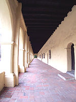
Points of
interestSee also Downtown · Eastside/Northeast · Harbor Area · Greater Hollywood · Westlake & Silver Lake/Los Feliz · San Fernando and Crescenta Valleys · South Los Angeles · Westside · WilshireCategories:- Neighborhoods in Los Angeles, California
- Communities in the San Fernando Valley
- Populated places established in 1910


Wikimedia Foundation. 2010.