- Campo de Cahuenga
Infobox nrhp2
name = Campo de Cahuenga
nrhp_type = hd
nhd = yes
designated_other1_name = California Historic Landmark
designated_other1_date =
designated_other1_abbr = CHISL
designated_other1_link = List of California Historical Landmarks
designated_other1_number = 151
designated_other1_color = #ffc94b
designated_other2_name = L.A. Historic-Cultural Monument
designated_other2_date =13 Nov ,1964 Citation | last = Los Angeles Department of City Planning | date =2007-09-07 | title = Historic - Cultural Monuments (HCM) Listing: City Declared Monuments | place = | publisher = City of Los Angeles | edition = | url =http://www.cityprojectca.org/ourwork/documents/HCMDatabase090707.pdf | accessdate = 2008-05-28 ]
designated_other2_abbr = LAHCM
designated_other2_link = Los Angeles Historic-Cultural Monument
designated_other2_number = 29
designated_other2_color = #ffc94b
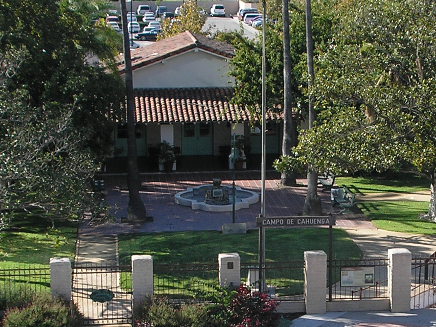
caption = Campo de Cahuenga
location = 3919 Lankershim Blvd.
Los Angeles, California
lat_degrees = 34
lat_minutes = 8
lat_seconds = 24
lat_direction = N
long_degrees = 118
long_minutes = 21
long_seconds = 42
long_direction = W
locmapin = California
area =
built =1847
architect= Landon and Spencer
architecture= Mission/Spanish Revival
added =19 Dec ,2003 cite web|url=http://www.nr.nps.gov/|title=National Register Information System|date=2008-04-15|work=National Register of Historic Places|publisher=National Park Service]
governing_body = Local
refnum=72001602Campo de Cahuenga in North Hollywood, California, near
Cahuenga Pass , was anadobe farmhouse on theRancho Verdugo where theTreaty of Cahuenga was signed between Lieutenant ColonelJohn C. Frémont and GeneralAndrés Pico in 1847, ending hostilities in California betweenMexico and theUnited States . The subsequentTreaty of Guadalupe Hidalgo of 1848, ceding California andTexas to the United States, formally ended theMexican-American War .The original adobe structure was demolished in 1900. The city ofLos Angeles provided funds for the purchase of the property in 1923, and a replica farmhouse built by the city following an effort led by Irene T. Lindsay, then President of theSan Fernando Valley Historical Society , was dedicated onNovember 2 1950 . It is now a park and interpretive center managed by the Los Angeles Department of Parks and Recreation in partnership with the Campo de Cahuenga Historical Memorial Association. Campo de Cahuenga is registered on theNational Register of Historic Places , and is designatedCalifornia Historical Landmark No. 151 and City of Los Angeles City Cultural Historical Monument No. 29.The foundations of the original adobe were unearthed beneath Lankershim Boulevard during construction of the Metro Red Line subway. The parts of the foundations within the park are preserved as an exhibit, and the "footprint" of the foundations under the street and sidewalk is marked by decorative pavement.
Campo de Cahuenga is located at 3919 Lankershim Blvd.,
North Hollywood, California , across from Universal Studios.Campo de Cahuenga is often confused with the nearby Rancho Cahuenga, an inholding within the Providencia land grant, now part of Burbank.
The building is used by various organizations for special programs and regular meetings, and is open with a docent on Saturdays.
ee also
*
List of Registered Historic Places in Los Angeles External links
* [http://www.laparks.org/dos/historic/campo.htm Los Angeles Department of Parks and Recreation - Campo de Cahuenga]
* [http://www.usc.edu/isd/archives/la/historic/campo_de_cahuenga.html Campo de Cahuenga at the University of Southern California Archives]
* [http://www.campodecahuenga.com/ Campo de Cahuenga Historical Memorial Association]References
*Jorgenson, Lawrence C.: "The San Fernando Valley Past and Present", Pacific Rim Research, Los Angeles, 1982 ISBN 0-941014-00-2
Wikimedia Foundation. 2010.