- National Register of Historic Places listings in San Luis Obispo County, California
-
This list includes properties and districts listed on the National Register of Historic Places in San Luis Obispo County, California. Click the "Map of all coordinates" link to the right to view a Google map of all properties and districts with latitude and longitude coordinates in the table below.[1]
-
- This National Park Service list is complete through NPS recent listings posted November 10, 2011.[2]
[3] Landmark name [4] Image Date listed Location City or town Summary 1 Administration Building, Atascadero Colony November 17, 1977 6500 Palma Ave.
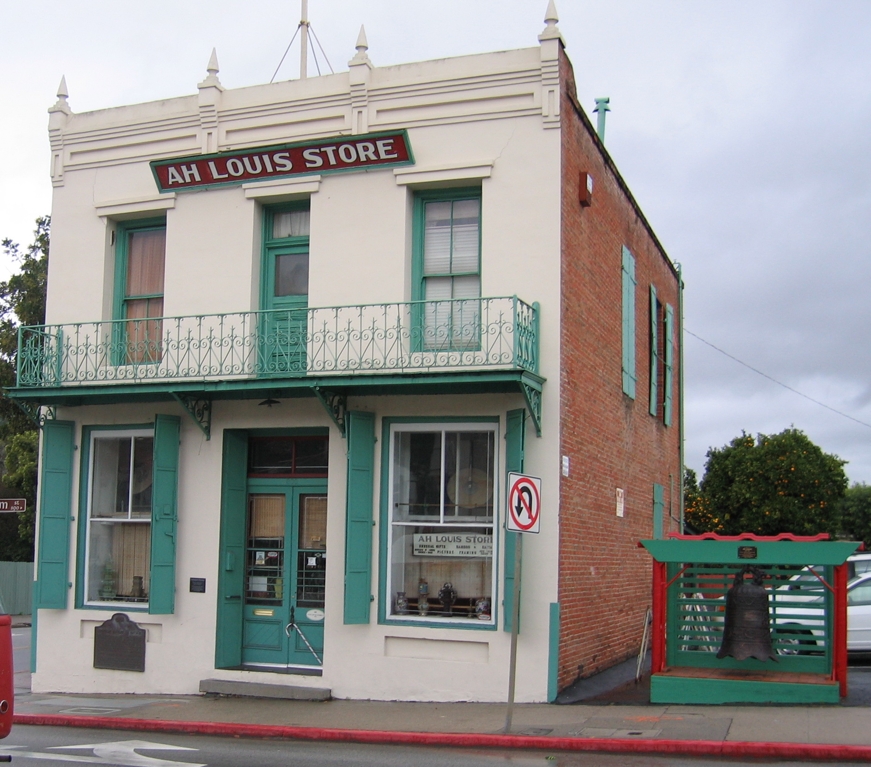
35°29′23″N 120°39′58″W / 35.489722°N 120.666111°WAtascadero 2 Ah Louis Store 
March 26, 2008 800 Palm St.
35°16′58″N 120°39′49″W / 35.282778°N 120.663611°WSan Luis Obispo 3 Myron Angel House November 22, 1982 714 Buchon St.
35°16′33″N 120°39′39″W / 35.275833°N 120.660833°WSan Luis Obispo 4 Archeological Site 4 SLO 834 February 25, 1982 Address Restricted Atascadero 5 Arroyo Grande IOOF Hall 
March 22, 1991 128 Bridge St.
35°07′20″N 120°34′38″W / 35.122222°N 120.577222°WArroyo Grande 6 Atascadero Printery January 2, 2004 6351 Olmeda
35°29′32″N 120°39′56″W / 35.492222°N 120.665556°WAtascadero 7 Bank of Italy March 19, 1998 1245 Park St.
35°37′39″N 120°41′21″W / 35.6275°N 120.689167°WPaso Robles 8 Brewster-Dutra House October 29, 1982 1803 Vine St.
35°37′59″N 120°41′37″W / 35.633056°N 120.693611°WPaso Robles 9 Caledonia Adobe 
July 14, 1971 0.5 mi. S of 10th St.
35°44′17″N 120°41′56″W / 35.738056°N 120.698889°WSan Miguel 10 Call-Booth House November 3, 1988 1315 Vine St.
35°37′40″N 120°41′35″W / 35.627778°N 120.693056°WPaso Robles 11 Carrizo Plain Rock Art Discontiguous District May 23, 2001 Address Restricted California Valley 12 Corral de Piedra May 22, 1978 S of San Luis Obispo on Price Canyon Rd.
35°11′37″N 120°37′28″W / 35.193611°N 120.624444°WSan Luis Obispo 13 Dana Adobe May 6, 1971 S end of Oak Glen Ave.
35°01′40″N 120°31′40″W / 35.027778°N 120.527778°WNipomo 14 Eight Mile House March 31, 1995 Off CA 101 on Stagecoach Rd.
35°22′02″N 120°38′17″W / 35.367222°N 120.638056°WSanta Margarita 15 Guthrie House January 10, 1980 Burton and Center Sts.
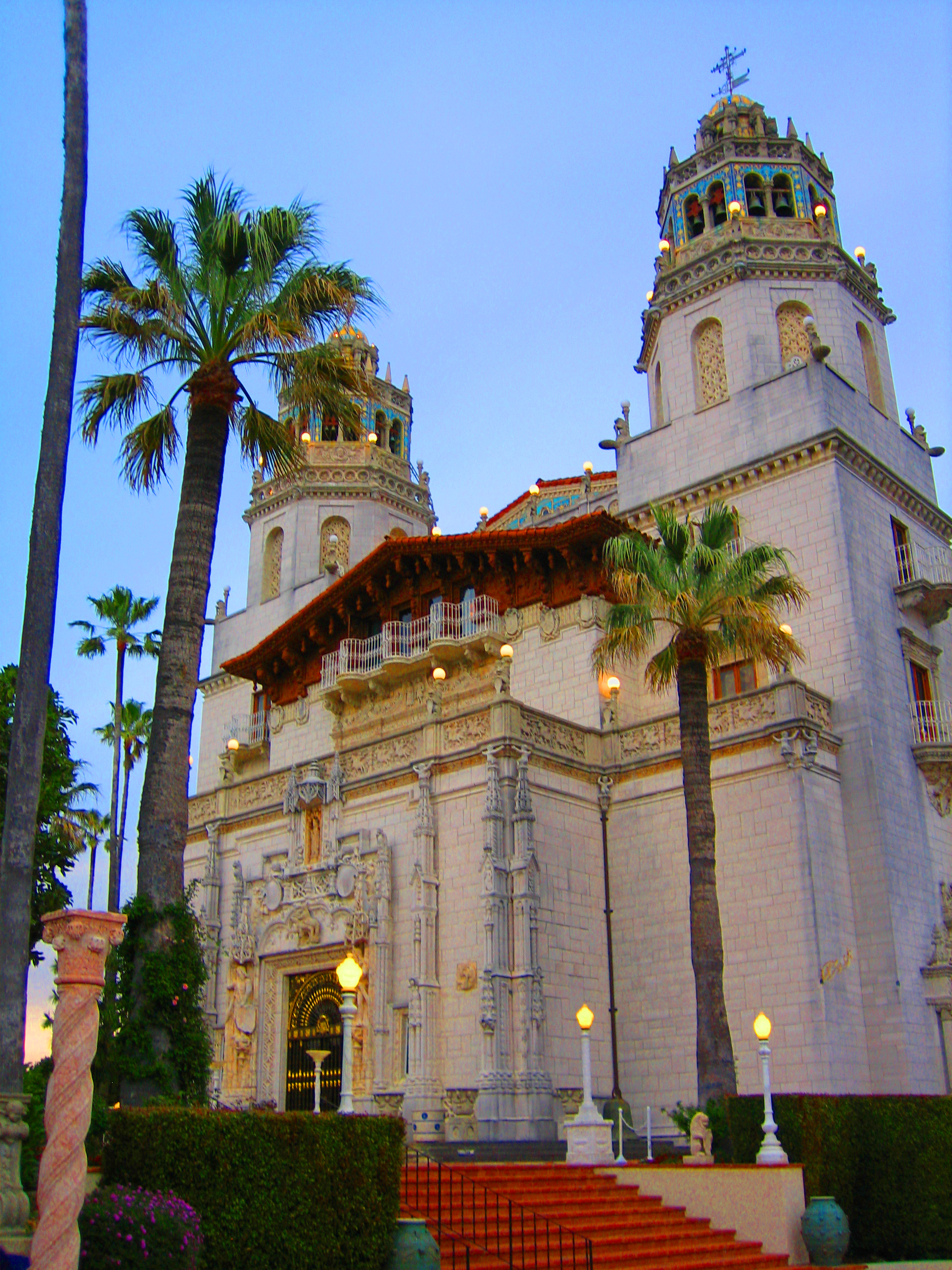
35°33′49″N 121°04′52″W / 35.563611°N 121.081111°WCambria 16 Hearst San Simeon Estate 
June 22, 1972 3 mi. NE of San Simeon
35°41′06″N 121°10′07″W / 35.685°N 121.168611°WSan Simeon 17 Robert Jack House April 13, 1992 536 Marsh St.
35°16′38″N 120°39′53″W / 35.277222°N 120.664722°WSan Luis Obispo 18 Lincoln School November 21, 2001 9000 Chimney Rock Rd.
35°40′05″N 120°51′18″W / 35.668056°N 120.855°WPaso Robles 19 Mission San Miguel Arcangel 
July 14, 1971 801 Mission Street (old CA 101)
35°37′59″N 120°41′37″W / 35.633056°N 120.693611°WSan Miguel 20 Old Santa Rosa Catholic Church and Cemetery October 29, 1982 Main St.
35°33′58″N 121°04′48″W / 35.566111°N 121.08°WCambria 21 Pacific Coast Railway Company Grain Warehouse June 23, 1988 65 Higuera St.
35°16′22″N 120°39′54″W / 35.272778°N 120.665°WSan Luis Obispo 22 Paso Robles Carnegie Library January 26, 1998 City Park, 800 12th St.
35°37′33″N 120°41′20″W / 35.625833°N 120.688889°WPaso Robles 23 Piedras Blancas Light Station 
September 3, 1991 CA 1 on Point Piedras Blancas
35°39′57″N 121°17′02″W / 35.665833°N 121.283889°WSan Simeon 24 Port San Luis Site May 22, 1978 Address Restricted San Luis Obispo 25 The Powerhouse July 30, 1993 Jct. of S. Perimeter Rd. and Cuesta Ave., NE corner
35°17′57″N 120°39′45″W / 35.299167°N 120.6625°WSan Luis Obispo 26 John Price House November 3, 1988 Highland Dr. off Price Canyon Rd.
35°08′52″N 120°38′20″W / 35.147778°N 120.638889°WPismo Beach 27 Rancho Canada de los Osos y Pecho y Islay June 20, 1975 Address Restricted San Luis Obispo 28 San Luis Obispo Carnegie Library 
March 30, 1995 696 Monterey St.
35°16′49″N 120°39′50″W / 35.280278°N 120.663889°WSan Luis Obispo 29 San Luis Obispo Light Station 
September 3, 1991 Point San Luis
35°09′42″N 120°45′26″W / 35.161667°N 120.757222°WAvila Beach 30 William Shipsey House March 31, 2010 1266 Mill St.
35°17′09″N 120°39′32″W / 35.285797°N 120.658967°WSan Luis Obispo 31 Tribune-Republic Building June 24, 1993 1763 Santa Barbara St.
35°16′33″N 120°39′21″W / 35.275833°N 120.655833°WSan Luis Obispo See also
- National Register of Historic Places listings in California
- List of National Historic Landmarks in California
References
- ^ The latitude and longitude information provided in this table was derived originally from the National Register Information System, which has been found to be fairly accurate for about 99% of listings. For about 1% of NRIS original coordinates, experience has shown that one or both coordinates are typos or otherwise extremely far off; some corrections may have been made. A more subtle problem causes many locations to be off by up to 150 yards, depending on location in the country: most NRIS coordinates were derived from tracing out latitude and longitudes off of USGS topographical quadrant maps created under North American Datum of 1927, which differs from the current, highly accurate GPS system used by Google maps. Chicago is about right, but NRIS longitudes in Washington are higher by about 4.5 seconds, and are lower by about 2.0 seconds in Maine. Latitudes differ by about 1.0 second in Florida. Some locations in this table may have been corrected to current GPS standards.
- ^ "National Register of Historic Places: Weekly List Actions". National Park Service, United States Department of the Interior. Retrieved on November 10, 2011.
- ^ Numbers represent an ordering by significant words. Various colorings, defined here, differentiate National Historic Landmark sites and National Register of Historic Places Districts from other NRHP buildings, structures, sites or objects.
- ^ "National Register Information System". National Register of Historic Places. National Park Service. . http://nrhp.focus.nps.gov/natreg/docs/All_Data.html.
U.S. National Register of Historic Places Topics Lists by states Alabama • Alaska • Arizona • Arkansas • California • Colorado • Connecticut • Delaware • Florida • Georgia • Hawaii • Idaho • Illinois • Indiana • Iowa • Kansas • Kentucky • Louisiana • Maine • Maryland • Massachusetts • Michigan • Minnesota • Mississippi • Missouri • Montana • Nebraska • Nevada • New Hampshire • New Jersey • New Mexico • New York • North Carolina • North Dakota • Ohio • Oklahoma • Oregon • Pennsylvania • Rhode Island • South Carolina • South Dakota • Tennessee • Texas • Utah • Vermont • Virginia • Washington • West Virginia • Wisconsin • WyomingLists by territories Lists by associated states Other  Category:National Register of Historic Places •
  Portal:National Register of Historic Places
Municipalities and communities of San Luis Obispo County, California County seat: San Luis Obispo Cities 
CDPs Avilla Beach | Blacklake | Callender | Cambria | Cayucos | Creston | Edna | Garden Farms | Lake Nacimiento | Los Berros | Los Osos | Los Ranchos | Nipomo | Oak Shores | Oceano | San Miguel | San Simeon | Santa Margarita | Shandon | Templeton | Whitley Gardens | Woodlands
Unincorporated
communitiesAdelaida | Asuncion | Baywood-Los Osos | Bee Rock | Bern | Bromela | California Valley | Cambria Pines | Cholame | Chorro | Halcyon | Harmony | Huasna | Pozo
Categories:- History of San Luis Obispo County, California
- San Luis Obispo County, California
- National Register of Historic Places in California by county
- Lists of National Register of Historic Places in California
-


Wikimedia Foundation. 2010.