- National Register of Historic Places listings in Rock Island County, Illinois
-
See also: List of Registered Historic Places in Illinois
This is intended to be a complete list of the properties and districts on the National Register of Historic Places in Rock Island County, Illinois, United States. Latitude and longitude coordinates are provided for many National Register properties and districts; these locations may be seen together in a Google map.[1]There are 24 properties and districts listed on the National Register in the county, including one National Historic Landmark and five historic districts. Twenty of the sites are in the city of Rock Island, while 3 are in Moline and 1 is in Hampton. The city of Rock Island, Illinois maintains an extensive on-line database of historic buildings and structure.[2]
-
- This National Park Service list is complete through NPS recent listings posted November 10, 2011.[3]
Landmark name Image Date listed Location City or Town Summary 1 Black Hawk Museum and Lodge 
March 4, 1985 1510 46th Ave.
41°27′51″N 90°34′21″W / 41.46417°N 90.5725°WRock Island Colonial Revival building that was built as a lodge in a state park. It currently houses the Hauberg Museum. 2 Black's Store 
May 28, 1976 1st Ave.
41°33′25″N 90°24′51″W / 41.55694°N 90.41417°WHampton The largest mercantile store in Northwest Illinois when it opened in the 1840s. The building housed the area's first elevator. 3 Broadway Historic District 
August 14, 1998 Roughly bounded by 17th and 23rd Sts., 5th and 7th Aves., Lincoln Court, and 12th and 13th Aves.
41°30′8″N 90°34′18″W / 41.50222°N 90.57167°WRock Island Historic District that contains more than 550 Victorian homes and other buildings. 4 Chippiannock Cemetery 
May 6, 1994 2901 Twelfth St.
41°28′54″N 90°34′40″W / 41.48167°N 90.57778°WRock Island Almerin Hotchkiss patterned his design on the Rural Cemetery style of Mt. Auburn Cemetery in Massachusetts. It contains monuments by Alexander Stirling Calder and Paul de Vigne. 5 Connor House 
August 11, 1988 702 Twentieth St.
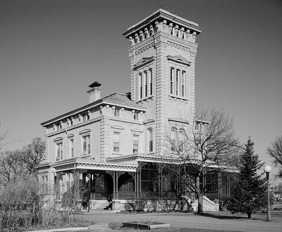
41°30′18″N 90°34′19″W / 41.505°N 90.57194°WRock Island An early example of the Queen Anne style in Rock Island. The home is located in the Broadway Historic District. 6 John Deere House 
February 5, 2003 1217 11th Ave.
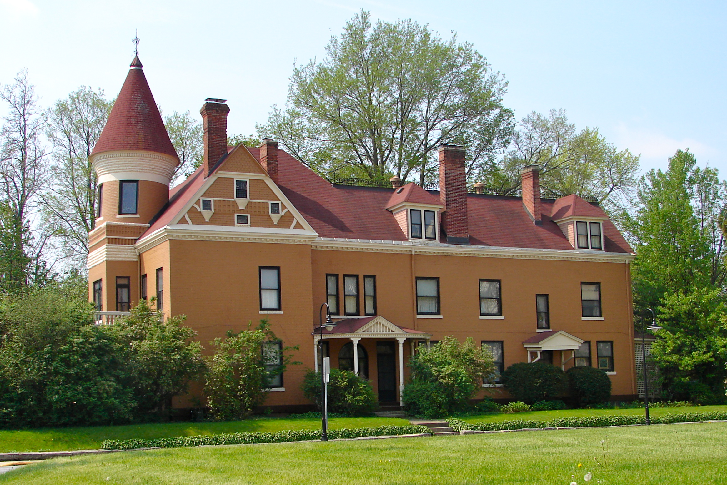
41°30′6″N 90°31′10″W / 41.50167°N 90.51944°WMoline The last home owned by inventor and industrialist John Deere. It was built in the Second Empire style. 7 Denkmann-Hauberg House 
December 26, 1972 1300 24th St.
41°29′33″N 90°34′24″W / 41.4925°N 90.57333°WRock Island Prairie School style home designed by Robert C. Spencer. Home to philanthropists John and Susanne (Denkmann) Hauberg 8 Fort Armstrong Hotel 
November 13, 1984 3rd Ave. and 19th St.
41°30′34″N 90°34′23″W / 41.50944°N 90.57306°WRock Island Renaissance Revival luxary hotel from the 1920s. 9 Fort Armstrong Theatre 
May 23, 1980 1826 3rd Ave.
41°30′36″N 90°34′18″W / 41.51°N 90.57167°WRock Island Art Deco movie palace that opened in 1920. 10 LeClaire Hotel 
February 4, 1994 Jct. of 19th St. and 5th Ave.
41°30′31″N 90°30′41″W / 41.50861°N 90.51139°WMoline Fifteen-story Renaissance Revival and Commercial style hotel that opened in 1915. It was the tallest building the Quad Cities when it opened. 11 Lincoln School 
August 29, 1985 7th Ave. and 22nd St.
41°30′20″N 90°34′9″W / 41.50556°N 90.56917°WRock Island Romanesque Revival school building designed by E.S. Hammatt. It opened in 1893 and ceased being used as a school in 1980. It was located in the Broadway Historic District. It will be demolished in 2012.[4] 12 Lock and Dam No. 15 Historic District 
March 10, 2004 NW of Rodman Ave., Twd., NW tip Arsenal Island
41°31′4″N 90°33′58″W / 41.51778°N 90.56611°WRock Island The largest roller dam in the world. 13 Moline Downtown Commercial Historic District 
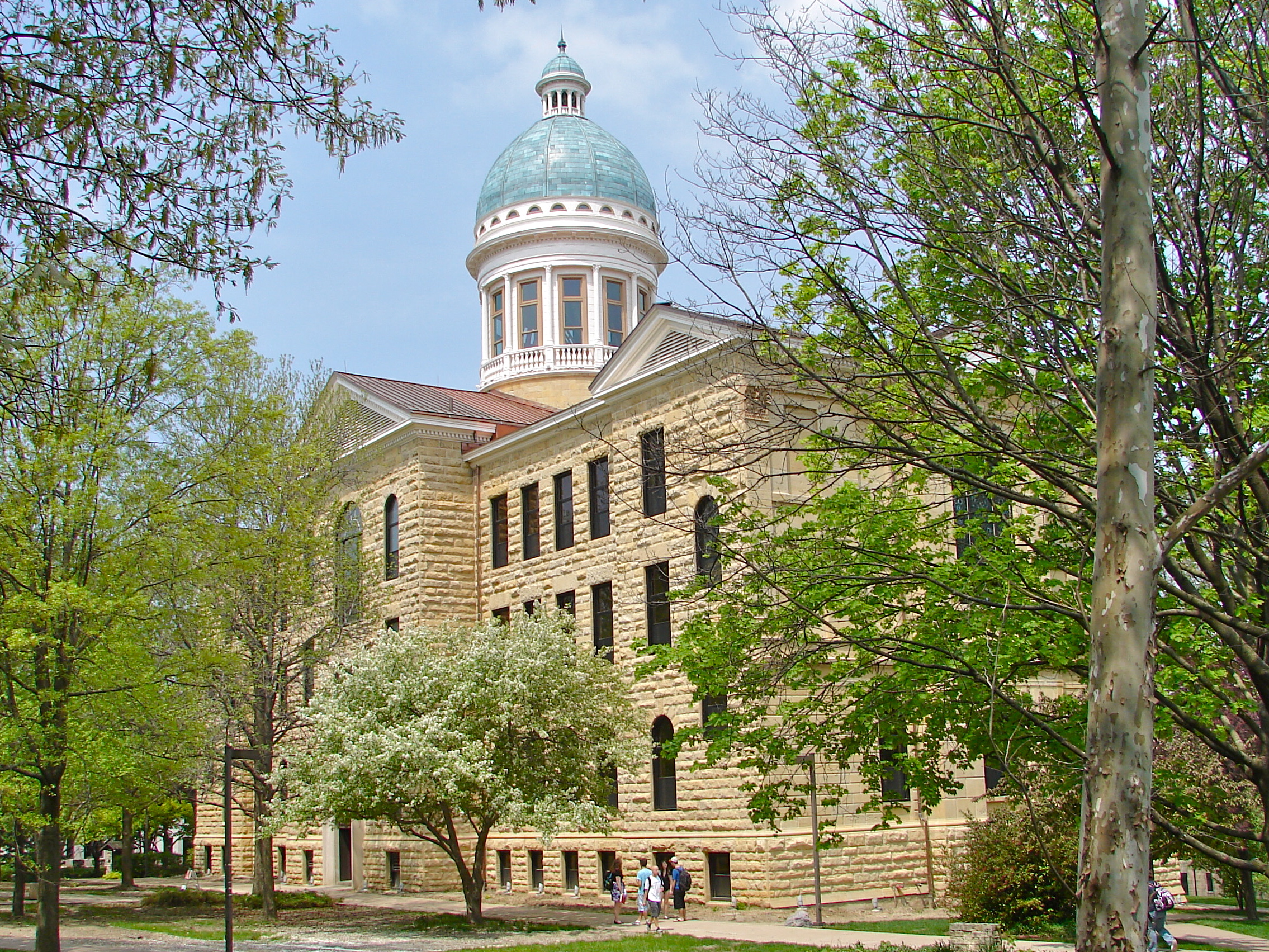
August 30, 2007 Roughly bounded by 12th St. to 18th St., 4th AVe. to 7th Ave. Moline Thirty-three acre section of the Central Business District in Moline. One hundred buildings contribute to its historical significance. 14 Old Main, Augustana College 
September 11, 1975 7th Ave. between 35th and 38th Sts.
41°30′15″N 90°32′58″W / 41.50417°N 90.54944°WRock Island Renaissance Revival building on the campus of Augustana College. It was built from 1884-1893. 15 Peoples National Bank Building-Fries Building 
November 22, 1999 1729–1731 and 1723-1727 2nd Ave.
41°30′39″N 90°34′30″W / 41.51083°N 90.575°WRock Island Two adjoining commercial buildings in downtown Rock Island. Both were built in the Classical Revival style in the late 19th century. 16 Potter House 
May 5, 1989 1906 7th Ave.
41°30′18″N 90°34′25″W / 41.505°N 90.57361°WRock Island Colonial Revival residence of newspaper owner Minnie Potter. It is located in the Broadway Historic District. 17 Rock Island Arsenal 
September 30, 1969 Rock Island in Mississippi River
41°30′58″N 90°32′21″W / 41.51611°N 90.53917°WRock Island Originally the site of Fort Armstrong, it is now the largest government-owned weapons manufacturing arsenal in the United States. Located on an island in the Mississippi River, it served as a prison camp during the American Civil War. 18 Rock Island Lines Passenger Station 
June 3, 1982 3029 5th Ave.
41°30′29″N 90°33′20″W / 41.50806°N 90.55556°WRock Island A Renaissance Revival style train depot that opened in 1901 and closed in 1980. It now serves as a banquette hall. 19 Rock Island National Cemetery 
June 13, 1997 0.25 mi N of southern tip of Rock Island
41°30′46″N 90°31′32″W / 41.51278°N 90.52556°WRock Island Established as a National Cemetery in 1863 during the American Civil War. It also contains a separate cemetery for the Confederate prisoners of war who were held on the island. 20 Sala Apartment Building 
August 21, 2003 320-330 Nineteenth St.
41°30′32″N 90°34′24″W / 41.50889°N 90.57333°WRock Island Renaissance Revival apartment building built in two sections in 1903 and 1913. 21 Stauduhar House 
March 5, 1982 1609 21st St.
41°29′43″N 90°34′15″W / 41.49528°N 90.57083°WRock Island Home of Rock Island architect George P. Stauduhar, which he designed in 1895. 22 Villa de Chantal Historic District 
May 22, 2005 2101 16th Ave.
41°29′55″N 90°34′13″W / 41.49861°N 90.57028°WRock Island Former Catholic girls school that opened in this location in 1901. Most of the main building was destroyed in a fire in 2005. 23 Robert Wagner House 
May 15, 1990 904 23rd St.
41°30′8″N 90°34′5″W / 41.50222°N 90.56806°WRock Island Classical Revival home of a Rock Island brewer and banker. Built in 1904 it is located in the Broadway Historic District. 24 Weyerhaeuser House 
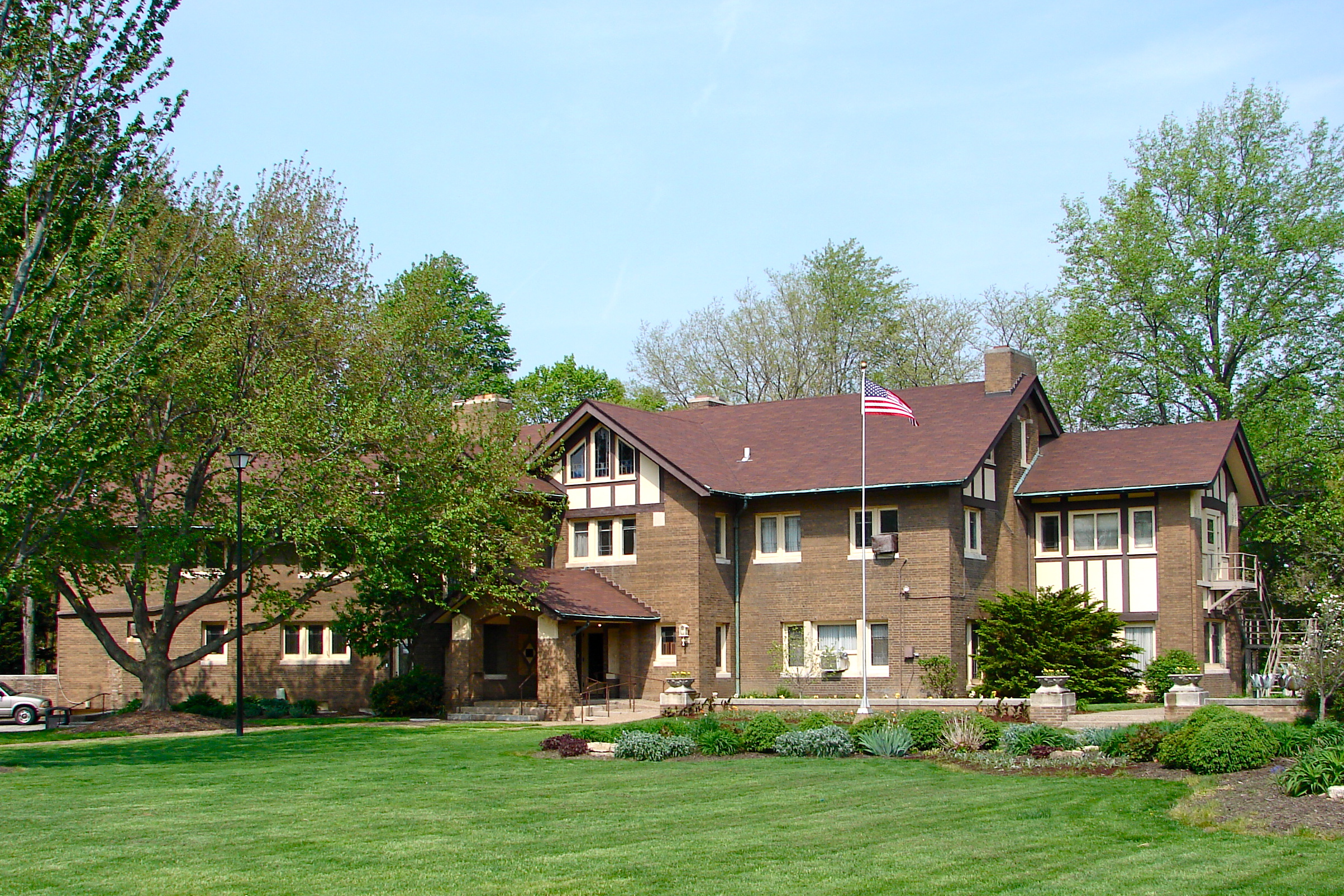
September 11, 1975 3052 10th Ave.
41°30′5″N 90°33′19″W / 41.50139°N 90.55528°WRock Island Rock Island home of lumber baron Frederick Weyerhaeuser. He bought the house in 1865 and extensively renovated it 1882-1883 in the Second Empire style. See also
- List of National Historic Landmarks in Illinois
- National Register of Historic Places listings in Illinois
References
- ^ The latitude and longitude information provided in this table was derived originally from the National Register Information System, which has been found to be fairly accurate for about 99% of listings. For about 1% of NRIS original coordinates, experience has shown that one or both coordinates are typos or otherwise extremely far off; some corrections may have been made. A more subtle problem causes many locations to be off by up to 150 yards, depending on location in the country: most NRIS coordinates were derived from tracing out latitude and longitudes off of USGS topographical quadrant maps created under the North American Datum of 1927, which differs from the current, highly accurate WGS84 GPS system used by Google maps. Chicago is about right, but NRIS longitudes in Washington are higher by about 4.5 seconds, and are lower by about 2.0 seconds in Maine. Latitudes differ by about 1.0 second in Florida. Some locations in this table may have been corrected to current GPS standards.
- ^ Rock Island Historic Structures Inventory, accessed June 14, 2011.
- ^ "National Register of Historic Places: Weekly List Actions". National Park Service, United States Department of the Interior. Retrieved on November 10, 2011.
- ^ http://www.wqad.com/news/wqad-council-approves-demolition-of-lincoln-school-building-20110920,0,1382899.story
U.S. National Register of Historic Places Topics Lists by states Alabama • Alaska • Arizona • Arkansas • California • Colorado • Connecticut • Delaware • Florida • Georgia • Hawaii • Idaho • Illinois • Indiana • Iowa • Kansas • Kentucky • Louisiana • Maine • Maryland • Massachusetts • Michigan • Minnesota • Mississippi • Missouri • Montana • Nebraska • Nevada • New Hampshire • New Jersey • New Mexico • New York • North Carolina • North Dakota • Ohio • Oklahoma • Oregon • Pennsylvania • Rhode Island • South Carolina • South Dakota • Tennessee • Texas • Utah • Vermont • Virginia • Washington • West Virginia • Wisconsin • WyomingLists by territories Lists by associated states Other Categories:- Rock Island County, Illinois
- National Register of Historic Places in Illinois by county
- National Register of Historic Places in Rock Island County, Illinois
-


Wikimedia Foundation. 2010.