- National Register of Historic Places listings in Owen County, Indiana
-
 Location of Owen County in Indiana
This is a list of the National Register of Historic Places listings in Owen County, Indiana.
This is intended to be a complete list of the properties and districts on the National Register of Historic Places in Owen County, Indiana, United States. Latitude and longitude coordinates are provided for many National Register properties and districts; these locations may be seen together in a Google map.[1]
There are 14 properties and districts listed on the National Register in the county. Another property was once listed but has been removed.
-
- This National Park Service list is complete through NPS recent listings posted November 10, 2011.[2]
Current listings
[3] Landmark name [4] Image Date listed Location City or town Summary 1 Allison-Robinson House 
June 3, 1993 3 N. Montgomery St.
39°17′11″N 86°45′49″W / 39.286389°N 86.763611°WSpencer 2 David Enoch Beem House 
July 13, 1989 635 W. Hillside Ave.
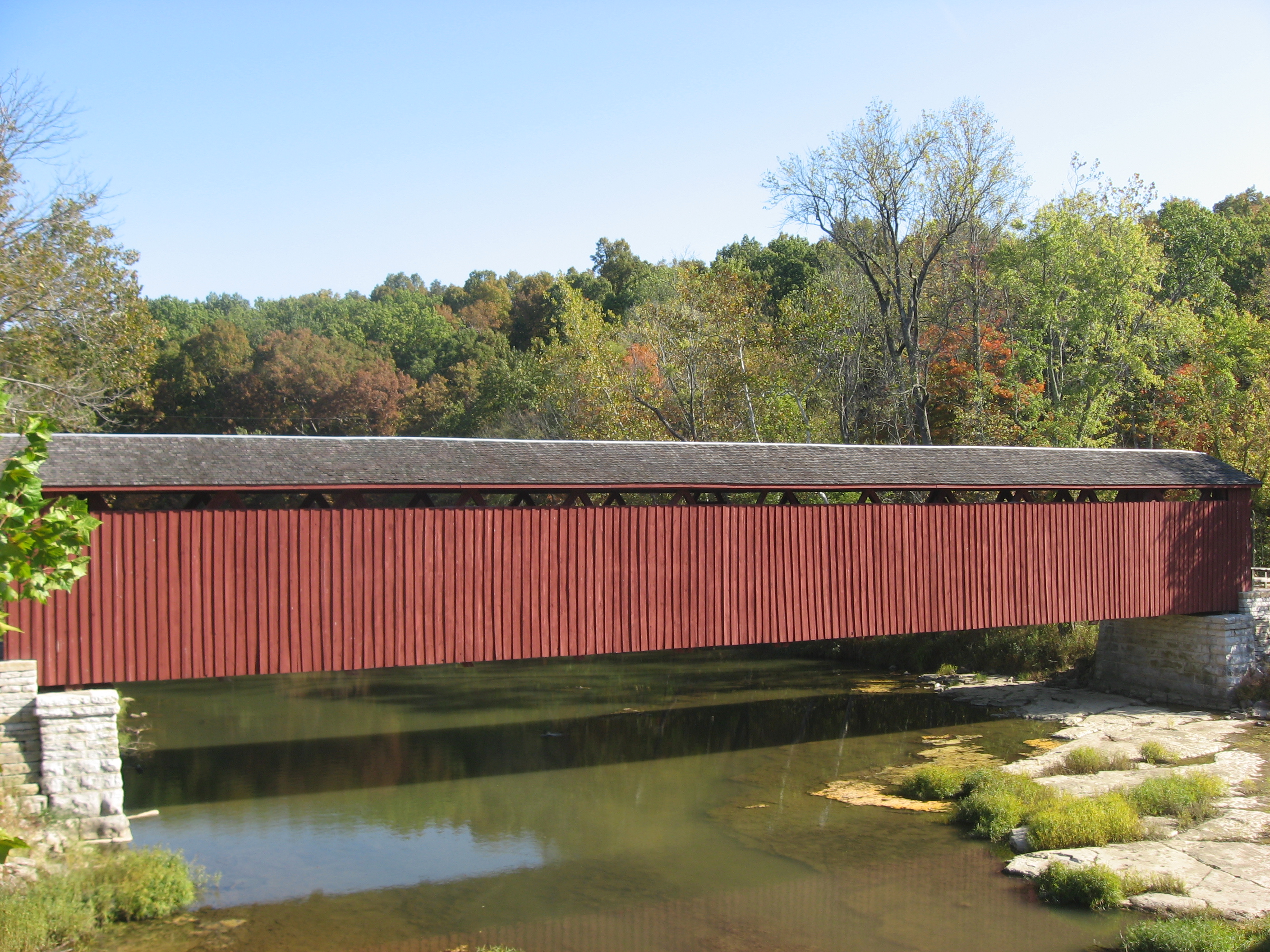
39°17′25″N 86°46′09″W / 39.290278°N 86.769167°WSpencer 3 Cataract Covered Bridge 
April 27, 2005 Junction of County Roads 235W and 1000N over Mill Creek in the Leiber State Recreation Area
39°26′00″N 86°48′48″W / 39.433333°N 86.813333°WCataract 4 CCC Recreation Building-Nature Museum 
March 18, 1993 McCormick's Creek State Park, west of the junction of State Roads 43 and 46
39°17′29″N 86°43′37″W / 39.291389°N 86.726944°WSpencer 5 Ennis Archaeological Site (12 OW 229) 
May 30, 1985 Along the Monroe/Owen county line on the southern edge of the Flatwoods region
39°14′18″N 86°41′3″W / 39.23833°N 86.68417°W[5]Ellettsville Extends into Monroe County 6 McCormick's Creek State Park Entrance and Gatehouse 
March 18, 1993 McCormick's Creek State Park, west of the junction of State Roads 43 and 46
39°17′02″N 86°43′34″W / 39.283889°N 86.726111°WSpencer 7 Moffett-Ralston House 
May 12, 1975 1.5 miles northeast of Patricksburg on Bixler Rd.
39°19′28″N 86°55′26″W / 39.324444°N 86.923889°WPatricksburg 8 Dr. H.G. Osgood House 
September 3, 1999 11 E. North St.
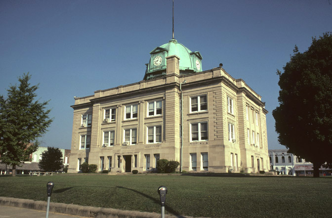
39°21′01″N 86°39′56″W / 39.350278°N 86.665556°WGosport 9 Owen County Courthouse 
November 25, 1994 Courthouse Square
39°17′08″N 86°45′43″W / 39.285556°N 86.761944°WSpencer 10 Secrest Ferry Bridge 
May 30, 1996 County Road 450E over the West Fork of the White River, south of Gosport
39°19′57″N 86°40′35″W / 39.3325°N 86.676389°WWayne Township Extends into Monroe County 11 Secrest-Wampler House 
March 20, 2002 1816 Concord Rd., southwest of Gosport
39°18′59″N 86°42′06″W / 39.316389°N 86.701667°WWashington Township 12 Spencer Public Library 
September 20, 2007 110 E. Market St.
39°17′05″N 86°45′38″W / 39.284722°N 86.760556°WSpencer 13 Spencer Town Hall and Fire Station 
August 19, 1982 84 S. Washington St.
39°17′07″N 86°45′40″W / 39.285278°N 86.761111°WSpencer Used as a law office (2005) 14 Stone Arch Bridge over McCormick's Creek 
March 18, 1993 McCormick's Creek State Park, west of the junction of State Roads 43 and 46
39°17′25″N 86°43′01″W / 39.290278°N 86.716944°WSpencer Former listing
[3] Landmark name Image Date listed Location City or town Summary 1 New Albany and Salem Railroad Station October 13, 1983 North St. at the White River
39°21′1.5″N 86°39′35″W / 39.350417°N 86.65972°WGosport Listed on August 6, 1976 See also
- List of National Historic Landmarks in Indiana
- National Register of Historic Places listings in Indiana
References
- ^ The latitude and longitude information provided in this table was derived originally from the National Register Information System, which has been found to be fairly accurate for about 99% of listings. For about 1% of NRIS original coordinates, experience has shown that one or both coordinates are typos or otherwise extremely far off; some corrections may have been made. A more subtle problem causes many locations to be off by up to 150 yards, depending on location in the country: most NRIS coordinates were derived from tracing out latitude and longitudes off of USGS topographical quadrant maps created under the North American Datum of 1927, which differs from the current, highly accurate WGS84 GPS system used by Google maps. Chicago is about right, but NRIS longitudes in Washington are higher by about 4.5 seconds, and are lower by about 2.0 seconds in Maine. Latitudes differ by about 1.0 second in Florida. Some locations in this table may have been corrected to current GPS standards.
- ^ "National Register of Historic Places: Weekly List Actions". National Park Service, United States Department of the Interior. Retrieved on November 10, 2011.
- ^ a b Numbers represent an ordering by significant words. Various colorings, defined here, differentiate National Historic Landmark sites and National Register of Historic Places Districts from other NRHP buildings, structures, sites or objects.
- ^ "National Register Information System". National Register of Historic Places. National Park Service. . http://nrhp.focus.nps.gov/natreg/docs/All_Data.html.
- ^ Location derived from Smith, Edward E. National Register of Historic Places Inventory/Nomination: Ennis Archaeological Site (12 Ow 229). National Park Service, n.d., 2. The NRIS lists the site as "Address Restricted".
U.S. National Register of Historic Places Topics Lists by states Alabama • Alaska • Arizona • Arkansas • California • Colorado • Connecticut • Delaware • Florida • Georgia • Hawaii • Idaho • Illinois • Indiana • Iowa • Kansas • Kentucky • Louisiana • Maine • Maryland • Massachusetts • Michigan • Minnesota • Mississippi • Missouri • Montana • Nebraska • Nevada • New Hampshire • New Jersey • New Mexico • New York • North Carolina • North Dakota • Ohio • Oklahoma • Oregon • Pennsylvania • Rhode Island • South Carolina • South Dakota • Tennessee • Texas • Utah • Vermont • Virginia • Washington • West Virginia • Wisconsin • WyomingLists by territories Lists by associated states Other Municipalities and communities of Owen County, Indiana Towns 
Townships Unincorporated
communitiesAdel | Alaska | Arney | Atkinsonville | Carp | Cataract | Coal City | Cuba | Cunot | Daggett | Denmark | Devore | Farmers | Freedom | Freeman | Hubbell | Jordan | Lewisville | New Hope | Patricksburg | Pottersville | Quincy | Romona | Silex | Smithville | Southport | Vandalia | Vilas | Wallace Junction | Whitehall
Categories:- Owen County, Indiana
- National Register of Historic Places in Indiana by county
-


Wikimedia Foundation. 2010.