- National Register of Historic Places listings in Gallatin County, Montana
-
 Location of Gallatin County in Montana
This is a list of the National Register of Historic Places listings in Gallatin County, Montana. It is intended to be a complete list of the properties and districts on the National Register of Historic Places in Gallatin County, Montana, United States. The locations of National Register properties and districts for which the latitude and longitude coordinates are included below, may be seen in a Google map.[1]
There are 102 properties and districts listed on the National Register in the county, including 1 National Historic Landmark.
-
- This National Park Service list is complete through NPS recent listings posted November 10, 2011.[2]
Listings county-wide
[3] Landmark name Image Date listed Location City or town Summary 1 Adams Block May 20, 1999 123 Main St.
45°53′36″N 111°33′05″W / 45.893333°N 111.551389°WThree Forks 2 Airway Radio Station November 5, 1998 Three Forks Airport
45°53′05″N 111°33′45″W / 45.884722°N 111.5625°WThree Forks 3 Anderson School July 21, 1981 East of Gallatin Gateway
45°35′53″N 111°06′14″W / 45.598056°N 111.103889°WGallatin Gateway 4 R.T. Barnett and Company Building December 1, 1980 13 E. Main St.
45°40′43″N 111°02′12″W / 45.678611°N 111.036667°WBozeman 5 Jack Bartlett House 
February 4, 2000 8 W. Harrison
45°40′08″N 111°02′59″W / 45.668889°N 111.049722°WBozeman 6 Beall Park Community Center 
October 23, 1987 409 N. Bozeman
45°41′02″N 111°02′03″W / 45.683889°N 111.034167°WBozeman 7 Belgrade City Hall and Jail October 25, 1982 Broadway at Northern Pacific Boulevard
45°46′33″N 111°10′33″W / 45.775833°N 111.175833°WBelgrade 8 Blackmore Apartments 
July 7, 1983 120 S. Black St.
45°40′41″N 111°02′00″W / 45.678056°N 111.033333°WBozeman 9 Bohart House 
October 23, 1987 510 N. Church
45°41′07″N 111°01′42″W / 45.685278°N 111.028333°WBozeman 10 Bon Ton Historic District October 23, 1987 Roughly bounded by Olive St., Willson Ave., Cleveland St., and 4th Ave.
45°40′38″N 111°02′36″W / 45.677222°N 111.043333°WBozeman 11 Bozeman Armory October 22, 1987 24 W. Mendenhall
45°40′49″N 111°02′14″W / 45.680278°N 111.037222°WBozeman 12 Bozeman Brewery Historic District October 23, 1987 700-800 N. Wallace Ave.
45°41′17″N 111°01′39″W / 45.688056°N 111.0275°WBozeman 13 Bozeman Carnegie Library 
February 2, 1979 35 N. Bozeman Ave.
45°40′49″N 111°02′00″W / 45.680278°N 111.033333°WBozeman 14 Bozeman National Fish Hatchery January 6, 1983 4050 Bridger Canyon Rd.
45°41′55″N 110°58′41″W / 45.698611°N 110.978056°WBozeman 15 Bozeman Sheet Metal Works October 23, 1987 26 S. Grand
45°40′44″N 111°02′20″W / 45.678889°N 111.038889°WBozeman 16 Bozeman YMCA October 23, 1987 6 W. Babcock
45°40′42″N 111°02′14″W / 45.678333°N 111.037222°WBozeman 17 Brandenburg House October 23, 1987 122 W. Lamme
45°40′51″N 111°02′20″W / 45.680833°N 111.038889°WBozeman 18 Bridger Arms Apartments October 23, 1987 103-111 S. 4th Ave.
45°40′41″N 111°02′30″W / 45.678056°N 111.041667°WBozeman 19 Busch House October 23, 1987 224 N. Church
45°41′02″N 111°01′44″W / 45.683889°N 111.028889°WBozeman 20 Buttelman Ranch 
April 19, 1993 Address Restricted Willow Creek 21 Colburn House October 23, 1987 607 W. Lamme
45°40′51″N 111°02′39″W / 45.680833°N 111.044167°WBozeman 22 Cooper Park Historic District October 23, 1987 200-700 blocks of S. 5th, 6th, 7th, 8th, and Cross Sts.
45°40′31″N 111°02′40″W / 45.675278°N 111.044444°WBozeman 23 Cottonwood School July 21, 1981 Southeast of Gallatin Gateway
45°38′00″N 111°07′35″W / 45.633333°N 111.126389°WGallatin Gateway 24 Crail Ranch Buildings April 15, 1982 Meadow Village
45°16′07″N 111°19′11″W / 45.268611°N 111.319722°WGallatin Gateway 25 Dokken-Nelson Funeral Home 
December 21, 1987 113 S. Willson
45°40′42″N 111°02′19″W / 45.678333°N 111.038611°WBozeman 26 Dry Creek School July 21, 1981 East of Manhattan
45°52′28″N 111°13′27″W / 45.874444°N 111.224167°WManhattan 27 Eagle's Store 
November 6, 1986 3 Canyon St.
44°39′34″N 111°05′53″W / 44.659444°N 111.098056°WWest Yellowstone 28 Emerson School 
August 10, 1990 111 S. Grand Ave.
45°40′42″N 111°02′22″W / 45.678333°N 111.039444°WBozeman 29 First Baptist Church 
October 23, 1987 120 S. Grand
45°40′40″N 111°02′21″W / 45.677778°N 111.039167°WBozeman 30 First Presbyterian Church December 21, 1987 26 W. Babcock
45°40′41″N 111°02′16″W / 45.678056°N 111.037778°WBozeman 31 Burr Fisher House March 28, 1985 712 S. Willson Ave.
45°40′18″N 111°02′16″W / 45.671667°N 111.037778°WBozeman 32 Flaming Arrow Lodge July 29, 1994 15521 Bridger Canyon Rd.
45°48′34″N 110°53′03″W / 45.809444°N 110.884167°WBozeman 33 Flaming Arrow Ranch House and Office March 12, 1998 15325 Bridger Canyon Rd.
45°48′31″N 110°52′58″W / 45.808611°N 110.882778°WBozeman 34 Gallatin County Courthouse December 21, 1987 301 W. Main
45°40′47″N 111°02′28″W / 45.679722°N 111.041111°WBozeman 35 Gallatin County High School January 22, 1988 404 W. Main
45°40′44″N 111°02′30″W / 45.678889°N 111.041667°WBozeman 36 Gallatin County Jail January 19, 1983 317 W. Main St.
45°40′47″N 111°02′30″W / 45.679722°N 111.041667°WBozeman 37 Gallatin Gateway Inn January 24, 1980 U.S. Route 191
45°35′37″N 111°11′54″W / 45.593611°N 111.198333°WGallatin Gateway 38 Gallatin Valley Seed Company October 23, 1987 209 S. Wallace
45°40′38″N 111°01′42″W / 45.677222°N 111.028333°WBozeman 39 Gifford House October 23, 1987 112 S. Grand
45°40′41″N 111°02′21″W / 45.678056°N 111.039167°WBozeman 40 Graf Building 
October 22, 1987 219-221 W. Arthur
45°40′08″N 111°02′25″W / 45.668889°N 111.040278°WBozeman 41 Green Ranch April 19, 1993 Address Restricted Willow Creek 42 Jesse R. Green Homestead January 21, 1992 6 miles northeast of Trident
45°59′05″N 111°22′09″W / 45.984722°N 111.369167°WTrident 43 Hamill Apartments 
October 23, 1987 427 E. Main
45°40′46″N 111°01′51″W / 45.679444°N 111.030833°WBozeman 44 Hamill House October 23, 1987 205 S. Church
45°40′38″N 111°01′49″W / 45.677222°N 111.030278°WBozeman 45 Harris House January 22, 1988 502 W. Mendenhall
45°40′49″N 111°02′35″W / 45.680278°N 111.043056°WBozeman 46 Hines House January 22, 1988 420 W. College
45°40′16″N 111°02′33″W / 45.671111°N 111.0425°WBozeman 47 Holy Rosary Church Rectory October 23, 1987 220 W. Main
45°40′44″N 111°02′23″W / 45.678889°N 111.039722°WBozeman 48 Hotel Baxter 
April 19, 1984 105 W. Main St.
45°40′46″N 111°04′37″W / 45.679444°N 111.076944°WBozeman 49 House at 22 West Lamme October 23, 1987 22 W. Lamme
45°40′51″N 111°02′14″W / 45.680833°N 111.037222°WBozeman 50 House at 714 North Tracy January 22, 1988 714 N. Tracy
45°41′18″N 111°02′09″W / 45.688333°N 111.035833°WBozeman 51 House at 818 South Eighth January 22, 1988 818 S. 8th
45°40′15″N 111°02′02″W / 45.670833°N 111.033889°WBozeman 52 Johnson House January 22, 1988 506 N. Bozeman
45°41′02″N 111°15′51″W / 45.683889°N 111.264167°WBozeman 53 Kennedy Building May 13, 1983 127 Yellowstone Ave.
44°39′34″N 111°05′59″W / 44.659444°N 111.099722°WWest Yellowstone 54 Emil Ketterer House March 31, 1983 35 N. Grand Ave.
45°40′49″N 111°02′21″W / 45.680278°N 111.039167°WBozeman 55 Kolble House October 23, 1987 716 S. Black
45°40′22″N 111°02′05″W / 45.672778°N 111.034722°WBozeman 56 Samuel Lewis House March 18, 1999 308 S. Bozeman Ave.
45°40′33″N 111°01′59″W / 45.675833°N 111.033056°WBozeman 57 Lindley Place Historic District October 23, 1987 200-300 Lindley Pl.
45°40′36″N 111°01′57″W / 45.676667°N 111.0325°WBozeman 58 Litening Gas October 22, 1987 424 E. Main
45°40′45″N 111°01′50″W / 45.679167°N 111.030556°WBozeman 59 Little Bear School April 15, 1982 Bear Creek Rd.
45°32′46″N 111°09′55″W / 45.546111°N 111.165278°WGallatin Gateway 60 Lonesomehurst Cabin August 18, 2011 Lonesomehurst Residential Residence Blk. A., Lot 1.
44°44′12″N 111°13′59″W / 44.736667°N 111.233056°WWest Yellowstone vicinity 61 Lower Bridger School July 21, 1981 East of Bozeman
45°42′11″N 110°55′44″W / 45.703056°N 110.928889°WBozeman 62 Lower Willow Creek Rural Historic Landscape District April 19, 1993 Address Restricted Willow Creek 63 Charles Lundwall Building January 4, 2001 123-125 W. Main St.
45°40′53″N 111°02′22″W / 45.681389°N 111.039444°WBozeman 64 Madison Buffalo Jump State Monument April 28, 1970 7 miles south of Logan
45°47′39″N 111°27′42″W / 45.794167°N 111.461667°WLogan 65 Madison Hotel and Cafe May 13, 1983 137 Yellowstone Ave.
44°39′30″N 111°06′00″W / 44.658333°N 111.1°WWest Yellowstone 66 Main Street Historic District 
December 21, 1987 100 block of W. Main through the 300 block of E. Main
45°40′47″N 111°02′05″W / 45.679722°N 111.034722°WBozeman 67 Malmborg School July 21, 1981 East of Bozeman
45°40′20″N 110°50′06″W / 45.672222°N 110.835°WBozeman 68 Maudlow School August 23, 1982 Milwaukee Rd.
46°06′27″N 111°10′17″W / 46.1075°N 111.171389°WBelgrade 69 Methodist Episcopal Church October 23, 1987 121 S. Willson
45°40′41″N 111°02′19″W / 45.678056°N 111.038611°WBozeman 70 Methodist Episcopal Church December 28, 2000 116 Cedar St.
45°53′43″N 111°33′00″W / 45.895278°N 111.55°WThree Forks 71 MISCO Grain Elevator 
October 23, 1987 700 N. Wallace
45°41′15″N 111°01′37″W / 45.6875°N 111.026944°WBozeman 72 Newman House 
October 23, 1987 216 N. Church
45°41′01″N 111°01′44″W / 45.683611°N 111.028889°WBozeman 73 North Tracy Avenue Historic District October 23, 1987 300-500 blocks of N. Tracy Ave., Bozeman, and Montana
45°41′04″N 111°02′12″W / 45.684444°N 111.036667°WBozeman 74 Northern Pacific-Story Mill Historic District May 10, 1996 Roughly bounded by the Northern Pacific right-of-way and the Story Mill spur line from Wye to Bridger Canyon Rd.
45°41′30″N 111°01′16″W / 45.691667°N 111.021111°WBozeman 75 Panton House October 23, 1987 801 S. 7th
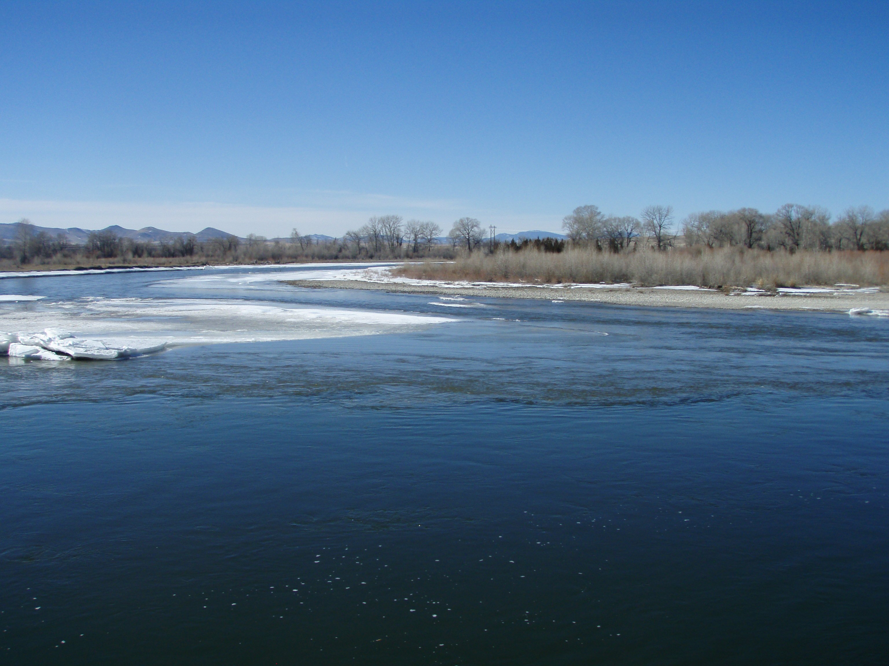
45°40′17″N 111°02′00″W / 45.671389°N 111.033333°WBozeman 76 Pass Creek School July 21, 1981 Northeast of Belgrade
45°58′40″N 111°05′52″W / 45.977778°N 111.097778°WBelgrade 77 Peterson House January 22, 1988 216 N. Wallace
45°41′00″N 111°01′42″W / 45.683333°N 111.028333°WBozeman 78 Peterson Place April 19, 1993 Address Restricted Willow Creek 79 Pine Butte School July 21, 1981 West of Bozeman
45°40′14″N 111°14′54″W / 45.670556°N 111.248333°WBozeman 80 Thomas Quaw House March 4, 1991 5 Central Ave.
45°46′36″N 111°10′27″W / 45.776667°N 111.174167°WBelgrade 81 Rea School July 21, 1981 West of Bozeman
45°40′19″N 111°07′27″W / 45.671944°N 111.124167°WBozeman 82 Reese Creek School July 21, 1981 Northeast of Belgrade
45°52′29″N 111°04′46″W / 45.874722°N 111.079444°WBelgrade 83 Rouse House October 23, 1987 506 E. Babcock
45°40′41″N 111°01′44″W / 45.678056°N 111.028889°WBozeman 84 Ruby Theatre April 30, 1982 212 Main St.
45°53′35″N 111°33′06″W / 45.893056°N 111.551667°WThree Forks 85 Sacajawea Hotel 
January 24, 1980 5 Main St.
45°53′44″N 111°33′03″W / 45.895556°N 111.550833°WThree Forks 86 Sedan School July 21, 1981 Northeast of Belgrade
45°57′30″N 110°51′03″W / 45.958333°N 110.850833°WBelgrade 87 South Tracy Avenue Historic District October 23, 1987 802-824 S. Tracy Ave.
45°40′16″N 111°02′14″W / 45.671111°N 111.037222°WBozeman 88 South Tracy-South Black Historic District December 21, 1987 200-600 blocks of S. Tracy and S. Black Aves.
45°40′31″N 111°02′11″W / 45.675278°N 111.036389°WBozeman 89 South Willson Historic District December 18, 1978 Willson Ave. between Curtiss and Arthur Sts.
45°40′21″N 111°02′19″W / 45.6725°N 111.038611°WBozeman 90 Spanish Creek School July 21, 1981 Northwest of Gallatin Gateway
45°29′27″N 111°19′50″W / 45.490833°N 111.330556°WGallatin Gateway 91 Spieth and Krug Brewery 
April 19, 1984 238-246 E. Main St.
45°40′54″N 111°01′53″W / 45.681667°N 111.031389°WBozeman 92 Spieth Houses October 23, 1987 204 N. Bozeman and 209 E. Lamme
45°40′55″N 111°01′59″W / 45.681944°N 111.033056°WBozeman 93 Springhill School July 21, 1981 Northeast of Belgrade
45°50′21″N 111°02′04″W / 45.839167°N 111.034444°WBelgrade 94 St. James Episcopal Church and Rectory October 23, 1987 9 W. Olive
45°40′40″N 111°02′12″W / 45.677778°N 111.036667°WBozeman 95 Stateler Memorial Methodist Church July 29, 2008 303 Main St.
45°49′32″N 111°38′42″W / 45.8256°N 111.64495°WWillow Creek 96 Story Motor Company October 23, 1987 202 W. Main
45°40′47″N 111°02′21″W / 45.679722°N 111.039167°WBozeman 97 Three Forks of the Missouri 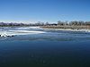
October 15, 1966 Northeast of Three Forks on the Missouri River, at Missouri Headwaters State Monument Three Forks 98 Three Valleys State Bank April 11, 2005 202 Main St.
45°53′35″N 111°33′07″W / 45.893056°N 111.551944°WThree Forks 99 Trident School July 21, 1981 South of Trident
45°56′58″N 111°28′24″W / 45.949444°N 111.473333°WTrident 100 Upper Madison School January 19, 1983 Buffalo Jump Rd.
45°44′38″N 111°28′07″W / 45.743889°N 111.468611°WThree Forks 101 Watkins Creek Ranch December 27, 2006 1207 Firehole Ranch Rd.
44°48′49″N 111°17′20″W / 44.8137°N 111.288858°WWest Yellowstone 102 West Yellowstone Oregon Shortline Terminus Historic District April 13, 1983 Yellowstone Ave.
44°39′30″N 111°06′06″W / 44.658333°N 111.101667°WWest Yellowstone See also
- List of National Historic Landmarks in Montana
- National Register of Historic Places listings in Montana
References
- ^ The latitude and longitude information provided in this table was derived originally from the National Register Information System, which has been found to be fairly accurate for about 99% of listings. For about 1% of NRIS original coordinates, experience has shown that one or both coordinates are typos or otherwise extremely far off; some corrections may have been made. A more subtle problem causes many locations to be off by up to 150 yards, depending on location in the country: most NRIS coordinates were derived from tracing out latitude and longitudes off of USGS topographical quadrant maps created under the North American Datum of 1927, which differs from the current, highly accurate WGS84 GPS system used by Google maps. Chicago is about right, but NRIS longitudes in Washington are higher by about 4.5 seconds, and are lower by about 2.0 seconds in Maine. Latitudes differ by about 1.0 second in Florida. Some locations in this table may have been corrected to current GPS standards.
- ^ "National Register of Historic Places: Weekly List Actions". National Park Service, United States Department of the Interior. Retrieved on November 10, 2011.
- ^ Numbers represent an ordering by significant words. Various colorings, defined here, differentiate National Historic Landmark sites and National Register of Historic Places Districts from other NRHP buildings, structures, sites or objects.
U.S. National Register of Historic Places Topics Lists by states Alabama • Alaska • Arizona • Arkansas • California • Colorado • Connecticut • Delaware • Florida • Georgia • Hawaii • Idaho • Illinois • Indiana • Iowa • Kansas • Kentucky • Louisiana • Maine • Maryland • Massachusetts • Michigan • Minnesota • Mississippi • Missouri • Montana • Nebraska • Nevada • New Hampshire • New Jersey • New Mexico • New York • North Carolina • North Dakota • Ohio • Oklahoma • Oregon • Pennsylvania • Rhode Island • South Carolina • South Dakota • Tennessee • Texas • Utah • Vermont • Virginia • Washington • West Virginia • Wisconsin • WyomingLists by territories Lists by associated states Other Municipalities and communities of Gallatin County, Montana Cities 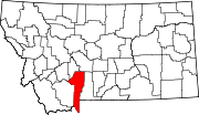
Towns CDPs Unincorporated
communityFootnotes ‡This populated place also has portions in an adjacent county or counties
Categories:- National Register of Historic Places in Montana by county
- Gallatin County, Montana
-


Wikimedia Foundation. 2010.