- National Register of Historic Places listings in Decatur County, Indiana
-
 Location of Decatur County in Indiana
This is a list of the National Register of Historic Places listings in Decatur County, Indiana.
This is intended to be a complete list of the properties and districts on the National Register of Historic Places in Decatur County, Indiana, United States. Latitude and longitude coordinates are provided for many National Register properties and districts; these locations may be seen together in a Google map.[1]
There are 10 properties and districts listed on the National Register in the county.
-
- This National Park Service list is complete through NPS recent listings posted November 10, 2011.[2]
Current listings
[3] Landmark name [4] Image Date listed Location City or town Summary 1 Bromwell Wire Works 
June 7, 1990 Junction of 1st and Ireland Sts.
39°20′39″N 85°29′22″W / 39.344167°N 85.489444°WGreensburg 2 Champ's Ford Bridge December 22, 2009 County Road 100S over Clifty Creek, 2 miles west of Burney
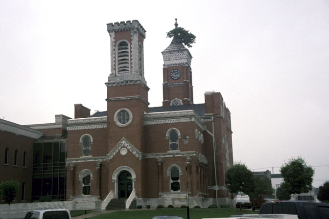
39°19′12″N 85°40′33″W / 39.319906°N 85.675853°WBurney 3 Decatur County Courthouse 
April 27, 1973 Courthouse Square
39°20′13″N 85°29′01″W / 39.336944°N 85.483611°WGreensburg 4 Greensburg Carnegie Public Library 
June 9, 1995 114 N. Michigan Ave.
39°20′23″N 85°29′09″W / 39.339722°N 85.485833°WGreensburg 5 Greensburg Downtown Historic District 
September 14, 1995 Roughly the area surrounding the courthouse square
39°20′15″N 85°29′01″W / 39.3375°N 85.483611°WGreensburg 6 Bright B. Harris House 
December 28, 2000 413 N. Franklin St.
39°20′25″N 85°28′59″W / 39.340278°N 85.483056°WGreensburg 7 Jerman School 
September 15, 2005 316 W. Walnut St.
39°20′32″N 85°29′13″W / 39.342222°N 85.486944°WGreensburg 8 Knights of Pythias Building and Theatre 
March 28, 1978 215 N. Broadway
39°20′17″N 85°29′05″W / 39.338056°N 85.484722°WGreensburg 9 Strauther Pleak Round Barn June 24, 1993 Moscow Rd., 0.2 miles east of County Road 100W
39°22′28″N 85°30′01″W / 39.374444°N 85.500278°WGreensburg 10 Westport Covered Bridge June 25, 1982 East of Westport
39°10′01″N 85°32′47″W / 39.166944°N 85.546389°WWestport See also
- List of National Historic Landmarks in Indiana
- National Register of Historic Places listings in Indiana
References
- ^ The latitude and longitude information provided in this table was derived originally from the National Register Information System, which has been found to be fairly accurate for about 99% of listings. For about 1% of NRIS original coordinates, experience has shown that one or both coordinates are typos or otherwise extremely far off; some corrections may have been made. A more subtle problem causes many locations to be off by up to 150 yards, depending on location in the country: most NRIS coordinates were derived from tracing out latitude and longitudes off of USGS topographical quadrant maps created under the North American Datum of 1927, which differs from the current, highly accurate WGS84 GPS system used by Google maps. Chicago is about right, but NRIS longitudes in Washington are higher by about 4.5 seconds, and are lower by about 2.0 seconds in Maine. Latitudes differ by about 1.0 second in Florida. Some locations in this table may have been corrected to current GPS standards.
- ^ "National Register of Historic Places: Weekly List Actions". National Park Service, United States Department of the Interior. Retrieved on November 10, 2011.
- ^ Numbers represent an ordering by significant words. Various colorings, defined here, differentiate National Historic Landmark sites and National Register of Historic Places Districts from other NRHP buildings, structures, sites or objects.
- ^ "National Register Information System". National Register of Historic Places. National Park Service. . http://nrhp.focus.nps.gov/natreg/docs/All_Data.html.
U.S. National Register of Historic Places Topics Lists by states Alabama • Alaska • Arizona • Arkansas • California • Colorado • Connecticut • Delaware • Florida • Georgia • Hawaii • Idaho • Illinois • Indiana • Iowa • Kansas • Kentucky • Louisiana • Maine • Maryland • Massachusetts • Michigan • Minnesota • Mississippi • Missouri • Montana • Nebraska • Nevada • New Hampshire • New Jersey • New Mexico • New York • North Carolina • North Dakota • Ohio • Oklahoma • Oregon • Pennsylvania • Rhode Island • South Carolina • South Dakota • Tennessee • Texas • Utah • Vermont • Virginia • Washington • West Virginia • Wisconsin • WyomingLists by territories Lists by associated states Other Municipalities and communities of Decatur County, Indiana City 
Towns Millhousen | New Point | St. Paul‡ | Westport
Townships Adams | Clay | Clinton | Fugit | Jackson | Marion | Salt Creek | Sand Creek | Washington
Unincorporated
communitiesAdams | Alert | Burney | Clarksburg | Craig | Downeyville | Ewington | Forest Hill | Gaynorsville | Germantown | Harper | Harris City | Horace | Kingston | Knarr Corner | Letts | Letts Corner | McCoy | Mechanicsburg | Middle Branch | Milford | New Pennington | Pinhook | Rossburg | Saint Maurice | Saint Omer | Sandusky | Sardinia | Slabtown | Smyrna | Waynesburg | Williamstown
Footnotes ‡This populated place also has portions in an adjacent county or counties
Categories:- Decatur County, Indiana
- National Register of Historic Places in Indiana by county
- National Register of Historic Places in Decatur County, Indiana
-


Wikimedia Foundation. 2010.