- National Register of Historic Places listings in Deer Lodge County, Montana
-
 Location of Deer Lodge County in Montana
This is a list of the National Register of Historic Places listings in Deer Lodge County, Montana. It is intended to be a complete list of the properties and districts on the National Register of Historic Places in Deer Lodge County, Montana, United States. All sites are located in the city of Anaconda, which is consolidated with Deer Lodge County. The locations of National Register properties and districts for which the latitude and longitude coordinates are included below, may be seen in a Google map.[1]
There are 33 properties and districts listed on the National Register in the county, including 1 National Historic Landmark.
-
- This National Park Service list is complete through NPS recent listings posted November 10, 2011.[2]
Listings county-wide
[3] Landmark name[4] Image Date listed Location Summary 1 Alpine Apartments October 30, 1998 200 Hickory
46°7′46″N 112°57′13″W / 46.12944°N 112.95361°W2 Anaconda Commercial Historic District 
February 25, 1998 Roughly bounded by Commercial Ave., Main St., Chestnut St., and E. Park Ave.
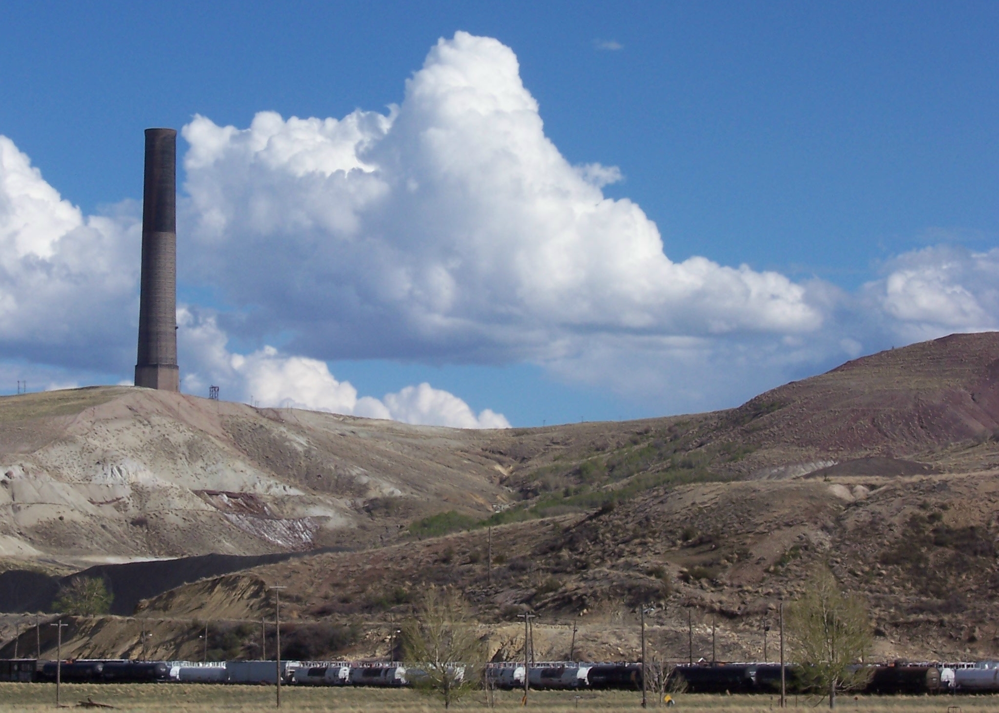
46°7′46″N 112°56′57″W / 46.12944°N 112.94917°W3 Anaconda Copper Mining Company Smoke Stack 
April 9, 1987 Anaconda Copper Smelter
46°6′37″N 112°54′47″W / 46.11028°N 112.91306°W4 Anaconda Saddle Club January 24, 2007 2704 Montana Highway 1, W. 5 Ancient Order of Hibernians Hall 
August 10, 1979 321-323 E. Commercial
46°7′46″N 112°56′54″W / 46.12944°N 112.94833°W6 Barich Block 
January 19, 1983 416-420 E. Park Ave.
46°7′47″N 112°57′5″W / 46.12972°N 112.95139°W7 Branscombe Automobile Machine Shop December 18, 2000 125 W. Commercial
46°7′56″N 112°57′14″W / 46.13222°N 112.95389°W8 Butte, Anaconda and Pacific Railway Historic District October 13, 1988 Right-of-way begins in Butte and travels to Anaconda, generally along the course of Silver Bow Creek
46°2′37″N 112°44′25″W / 46.04361°N 112.74028°WExtends into Silver Bow County 9 Butte-Anaconda Historic District 
October 15, 1966 Most of the developed areas of Anaconda, Butte, and Walkerville
46°7′45″N 112°57′10″W / 46.12917°N 112.95278°WExtends into Silver Bow County 10 California Creek Quarry January 20, 1989 Address Restricted 11 City Hall August 10, 1979 401 E. Commercial
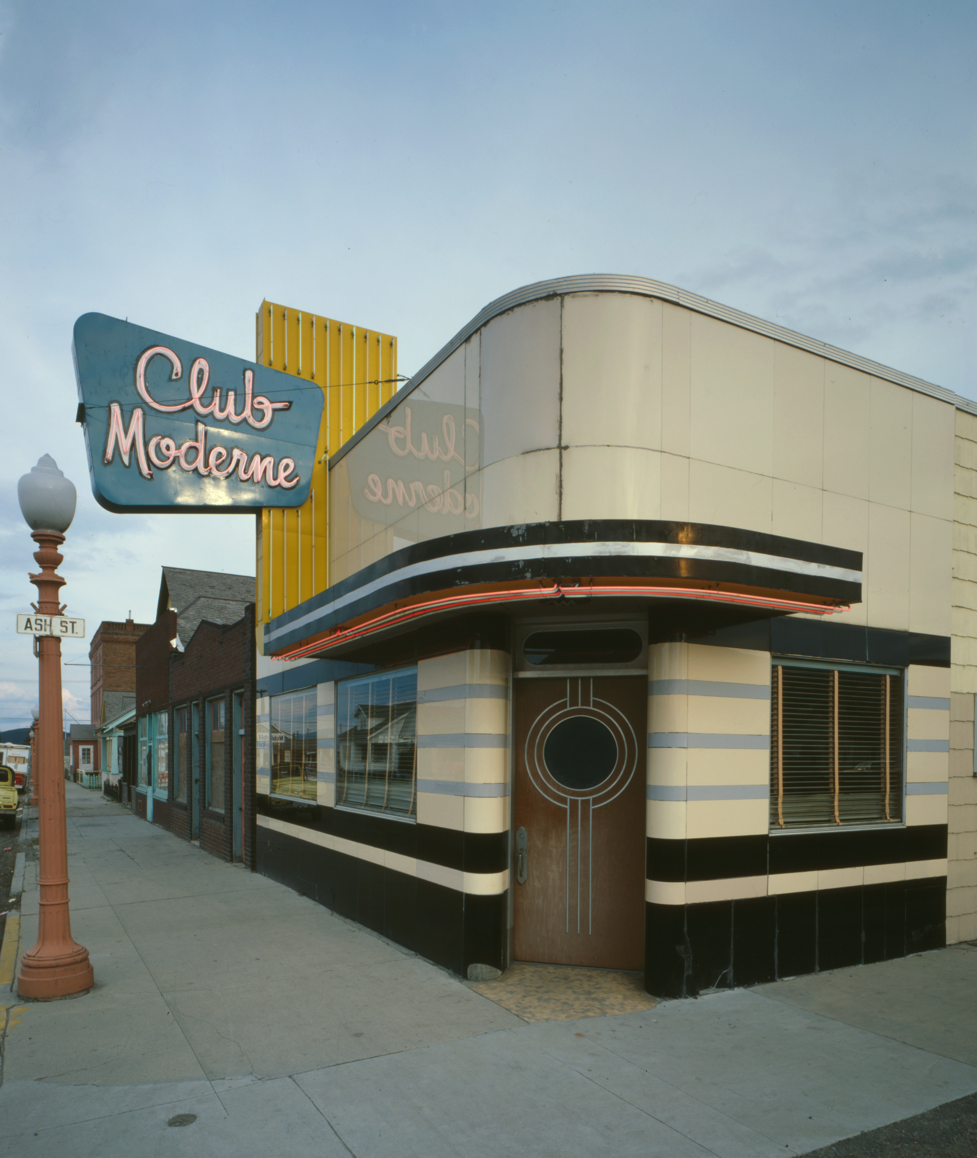
46°7′46″N 112°56′51″W / 46.12944°N 112.9475°W12 Club Moderne 
August 14, 1986 811 E. Park
46°7′40″N 112°56′38″W / 46.12778°N 112.94389°W13 James V. Collins House December 18, 2000 422 W. 3rd St.
46°7′52″N 112°57′31″W / 46.13111°N 112.95861°W14 Davidson Building January 19, 1983 301-303 E. Park St.
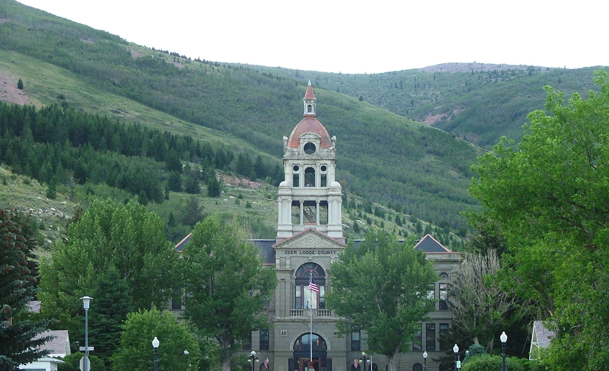
46°7′47″N 112°57′14″W / 46.12972°N 112.95389°W15 Deer Lodge County Courthouse 
December 29, 1978 U.S. Route 10
46°7′21″N 112°57′18″W / 46.1225°N 112.955°W16 Theodore Eck House October 30, 1998 1217 W. 4th St.
46°7′48″N 112°58′10″W / 46.13°N 112.96944°W17 John Furst House October 30, 1998 1403 W. 3rd St.
46°7′53″N 112°58′16″W / 46.13139°N 112.97111°W18 Glover Cabin December 18, 2000 Washoe Park
46°8′10″N 112°57′56″W / 46.13611°N 112.96556°W19 Goosetown Historic District February 25, 1998 Roughly bounded by Cedar St., Monroe St., the Birch Hill Allotment, and E. Commercial Ave.
46°7′28″N 112°56′35″W / 46.12444°N 112.94306°W20 Granite Apartments December 18, 2000 214 E. 3rd St.
46°7′48″N 112°57′4″W / 46.13°N 112.95111°W21 Hearst Free Library 
June 4, 1973 Main and 4th Sts.
46°7′37″N 112°57′9″W / 46.12694°N 112.9525°W22 Lorraine Apartments December 18, 2000 218 E. 3rd
46°7′47″N 112°57′2″W / 46.12972°N 112.95056°W23 Duncan Matheson House October 30, 1998 1300 W. 3rd St.
46°7′53″N 112°58′10″W / 46.13139°N 112.96944°W24 Methodist Episcopal Church of Anaconda July 29, 1994 Junction of Oak and E. 3rd Sts.
46°7′42″N 112°57′2″W / 46.12833°N 112.95056°W25 Morel Bridge December 12, 2000 25200 East Side Rd.
46°9′28″N 112°46′16″W / 46.15778°N 112.77111°W26 The New Brunswick House December 18, 2000 325 E. Front
46°7′56″N 112°56′54″W / 46.13222°N 112.94833°W27 Sheehan Boardinghouse December 18, 2000 412 E. 3rd St.
46°7′42″N 112°56′54″W / 46.12833°N 112.94833°W28 St. Mark's Episcopal Church December 29, 1978 601 Main St.
46°7′29″N 112°57′14″W / 46.12472°N 112.95389°W29 US Post Office-Anaconda Main March 14, 1986 218 Main St.
46°7′44″N 112°57′9″W / 46.12889°N 112.9525°W30 George Waddell House October 30, 1998 506 W. 3rd St.
46°7′46″N 112°57′30″W / 46.12944°N 112.95833°W31 Washoe Theater 
April 30, 1982 305 Main St.
46°7′39″N 112°57′8″W / 46.1275°N 112.95222°W32 West Side Historic District April 28, 1998 Roughly bounded by Main St., W. 8th St., W. Park Ave., and Maple St.
46°7′33″N 112°57′17″W / 46.12583°N 112.95472°W33 Zion Swedish Evangelical Lutheran Church October 30, 1998 524 Cedar St.
46°7′29″N 112°56′57″W / 46.12472°N 112.94917°WSee also
- List of National Historic Landmarks in Montana
- National Register of Historic Places listings in Montana
References
- ^ The latitude and longitude information provided in this table was derived originally from the National Register Information System, which has been found to be fairly accurate for about 99% of listings. For about 1% of NRIS original coordinates, experience has shown that one or both coordinates are typos or otherwise extremely far off; some corrections may have been made. A more subtle problem causes many locations to be off by up to 150 yards, depending on location in the country: most NRIS coordinates were derived from tracing out latitude and longitudes off of USGS topographical quadrant maps created under the North American Datum of 1927, which differs from the current, highly accurate WGS84 GPS system used by Google maps. Chicago is about right, but NRIS longitudes in Washington are higher by about 4.5 seconds, and are lower by about 2.0 seconds in Maine. Latitudes differ by about 1.0 second in Florida. Some locations in this table may have been corrected to current GPS standards.
- ^ "National Register of Historic Places: Weekly List Actions". National Park Service, United States Department of the Interior. Retrieved on November 10, 2011.
- ^ Numbers represent an ordering by significant words. Various colorings, defined here, differentiate National Historic Landmark sites and National Register of Historic Places Districts from other NRHP buildings, structures, sites or objects.
- ^ "National Register Information System". National Register of Historic Places. National Park Service. 2008-04-24. http://nrhp.focus.nps.gov/natreg/docs/All_Data.html.
U.S. National Register of Historic Places Topics Lists by states Alabama • Alaska • Arizona • Arkansas • California • Colorado • Connecticut • Delaware • Florida • Georgia • Hawaii • Idaho • Illinois • Indiana • Iowa • Kansas • Kentucky • Louisiana • Maine • Maryland • Massachusetts • Michigan • Minnesota • Mississippi • Missouri • Montana • Nebraska • Nevada • New Hampshire • New Jersey • New Mexico • New York • North Carolina • North Dakota • Ohio • Oklahoma • Oregon • Pennsylvania • Rhode Island • South Carolina • South Dakota • Tennessee • Texas • Utah • Vermont • Virginia • Washington • West Virginia • Wisconsin • WyomingLists by territories Lists by associated states Other Categories:- National Register of Historic Places in Montana by county
- Deer Lodge County, Montana
-


Wikimedia Foundation. 2010.