- National Register of Historic Places listings in Anderson County, Texas
-
List of Registered Historic Places in Anderson County, Texas
This is intended to be a complete list of properties and districts listed on the National Register of Historic Places in Anderson County, Texas. The locations of National Register properties and districts (at least for all showing latitude and longitude coordinates below) may be seen in a Google map by clicking on "Map of all coordinates".[1]
-
- This National Park Service list is complete through NPS recent listings posted November 10, 2011.[2]
[3] Landmark name [4] Image Date listed Location City or town Summary 1 Anderson Camp Ground December 27, 1982 W of Brushy Creek on Farm to Market Road 837
31°57′14″N 95°37′23″W / 31.953889°N 95.623056°WBrushy Creek Ref. # 82001735, aka Brushy Creek Arbor and United Methodist Church 2 Anderson County Courthouse 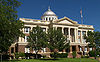
September 28, 1992 1 Public Sq.
31°45′54″N 95°37′34″W / 31.765°N 95.626111°WPalestine Ref. #92001256 3 Anderson County Jail June 11, 1998 704 Avenue A
31°45′50″N 95°37′36″W / 31.763889°N 95.626667°WPalestine Ref. #98000692 4 William and Caroline Broyles House November 10, 1988 1305 S. Sycamore St.
31°44′52″N 95°37′44″W / 31.747778°N 95.628889°WPalestine Ref. #88002614, aka The Broyles House 5 Denby Building June 11, 1998 201 W. Crawford St.
31°45′47″N 95°37′56″W / 31.763056°N 95.632222°WPalestine Ref. #98000694 6 G. E. Dilley Building June 11, 1998 503 W. Main St.
31°45′44″N 95°38′05″W / 31.762222°N 95.634722°WPalestine Ref. #98000698 7 First Presbyterian Church June 11, 1998 406 Avenue A
31°45′45″N 95°37′44″W / 31.7625°N 95.628889°WPalestine Ref. #98000695 8 Freeman Farm June 12, 2000 Co. Rd. 323, 3 miles SE of Frankston
31°59′38″N 95°29′53″W / 31.993889°N 95.498056°WFrankston aka Kickapoo Farn, Freeman Plantation 9 Gatewood-Shelton Gin June 3, 1998 304 E. Crawford
31°45′50″N 95°37′41″W / 31.763889°N 95.628056°WPalestine Ref. #98000637 10 Howard House March 14, 1993 1011 N. Perry St.
31°46′11″N 95°37′34″W / 31.769722°N 95.626111°WPalestine Ref. #93000072 11 Lincoln High School June 3, 1998 920 W. Swantz St.
31°45′20″N 95°38′26″W / 31.755556°N 95.640556°WPalestine Ref. #98000636 12 Link House May 29, 1980 925 N. Link St.
31°45′48″N 95°38′18″W / 31.763333°N 95.638333°WPalestine Ref. #80004073, aka Link-Bunton House 13 Michaux Park Historic District April 28, 2004 Roughly bounded by S. Michaux St., Jolly St., Crokett Rd., Rogers St., and E Park Ave.
31°45′29″N 95°24′34″W / 31.758056°N 95.409444°WPalestine Ref. #4000380, 295 buildings 14 Mount Vernon African Methodist Episcopal Church June 3, 1998 913 E. Calhoun St.
31°46′05″N 95°37′22″W / 31.768056°N 95.622778°WPalestine Ref. #98000635 15 North Side Historic District July 1, 1998 Roughly bounded by Kolsted, N. Perry, W. Green, and N. Conrad Sts.
31°46′07″N 95°37′53″W / 31.768611°N 95.631389°WPalestine Ref. #98000825, 135 buildings 16 Old Town Residential Historic District June 15, 2006 Roughly surrounded by Lacey St.
31°46′02″N 95°37′22″W / 31.767222°N 95.622778°WPalestine Ref. #6000509, 45 buildings 17 Pace McDonald Site August 12, 1982 Address Restricted Palestine Ref. #82004488, 41AN51 18 Palestine Carnegie Library 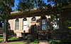
October 17, 1988 502 N. Queen St.
31°45′48″N 95°38′04″W / 31.763333°N 95.634444°WPalestine Ref. #88001944 19 Palestine High School September 24, 1986 400 Micheaux Ave.
31°45′29″N 95°37′38″W / 31.758056°N 95.627222°WPalestine Ref. #86002295, 20 Post Office--Palestine June 11, 1998 101 E. Oak St.
31°45′46″N 95°37′51″W / 31.762778°N 95.630833°WPalestine Ref. #98000693 21 John H Reagan Monument June 3, 1998 Reagan Park; vicinity of Park and Crockett Sts.
31°46′00″N 95°37′32″W / 31.766667°N 95.625556°WPalestine Ref. #98000623 22 Redlands Hotel June 3, 1998 400 N. Queen St.
31°45′46″N 95°38′02″W / 31.762778°N 95.633889°WPalestine Ref. #98000634 23 Robinson Bank Building June 11, 1998 213 W. Main St.
31°45′44″N 95°37′58″W / 31.762222°N 95.632778°WPalestine Ref. #98000691 24 Sacred Heart Catholic Church and School December 6, 1979 503 N. Queen St.
31°45′45″N 95°38′04″W / 31.7625°N 95.634444°WPalestine Ref. #79002909 25 A. C. Saunders Site July 15, 1982 Address Restricted Frankston Ref. #82004487, 41AN19 26 South Side Historic District July 1, 1998 Roughly bounded by W. Colorado, and S. Michaux Sts., and Union Pacific Railroad Tracks
31°45′21″N 95°37′50″W / 31.755833°N 95.630556°WPalestine Ref. #98000826, 189 buildings 27 Texas & Pacific Steam Locomotive No. 610 March 25, 1977 Park Road 70
34°44′28″N 95°34′16″W / 34.74118°N 95.5712°WPalestine See also
- Registered Historic Places in Texas, Counties A-C
References
- ^ The latitude and longitude information provided in this table was derived originally from the National Register Information System, which has been found to be fairly accurate for about 99% of listings. For about 1% of NRIS original coordinates, experience has shown that one or both coordinates are typos or otherwise extremely far off; some corrections may have been made. A more subtle problem causes many locations to be off by up to 150 yards, depending on location in the country: most NRIS coordinates were derived from tracing out latitude and longitudes off of USGS topographical quadrant maps created under the North American Datum of 1927, which differs from the current, highly accurate WGS84 GPS system used by Google maps. Chicago is about right, but NRIS longitudes in Washington are higher by about 4.5 seconds, and are lower by about 2.0 seconds in Maine. Latitudes differ by about 1.0 second in Florida. Some locations in this table may have been corrected to current GPS standards.
- ^ "National Register of Historic Places: Weekly List Actions". National Park Service, United States Department of the Interior. Retrieved on November 10, 2011.
- ^ Numbers represent an ordering by significant words. Various colorings, defined here, differentiate National Historic Landmark sites and National Register of Historic Places Districts from other NRHP buildings, structures, sites or objects.
- ^ "National Register Information System". National Register of Historic Places. National Park Service. . http://nrhp.focus.nps.gov/natreg/docs/All_Data.html.
U.S. National Register of Historic Places Topics Lists by states Alabama • Alaska • Arizona • Arkansas • California • Colorado • Connecticut • Delaware • Florida • Georgia • Hawaii • Idaho • Illinois • Indiana • Iowa • Kansas • Kentucky • Louisiana • Maine • Maryland • Massachusetts • Michigan • Minnesota • Mississippi • Missouri • Montana • Nebraska • Nevada • New Hampshire • New Jersey • New Mexico • New York • North Carolina • North Dakota • Ohio • Oklahoma • Oregon • Pennsylvania • Rhode Island • South Carolina • South Dakota • Tennessee • Texas • Utah • Vermont • Virginia • Washington • West Virginia • Wisconsin • WyomingLists by territories Lists by associated states Other Categories:- Anderson County, Texas
- National Register of Historic Places in Texas
- Buildings and structures in Anderson County, Texas
-


Wikimedia Foundation. 2010.