- Mount Davidson (California)
-
Mount Davidson 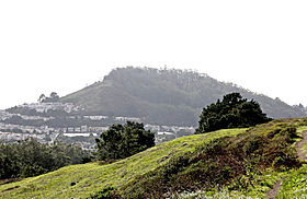
Mount Davidson as seen from the Twin Peaks.Elevation 928 ft (283 m) NAVD 88[1] Listing San Francisco Hill
California County High Point [2]Location Location of Mount Davidson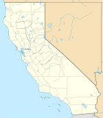
 Mount Davidson
Location San Francisco, California, United States Coordinates 37°44′18″N 122°27′12″W / 37.7382643°N 122.4533047°WCoordinates: 37°44′18″N 122°27′12″W / 37.7382643°N 122.4533047°W[1] Topo map USGS San Francisco South Climbing Easiest route Hike Mount Davidson Park 

Type Municipal (San Francisco) Location San Francisco Coordinates 37°44′18″N 122°27′18″W / 37.7382643°N 122.4549715°WCoordinates: 37°44′18″N 122°27′18″W / 37.7382643°N 122.4549715°W Area 38 acres (15 ha) Created 1920s Status Open all year Mount Davidson is the highest natural point in San Francisco, California, with an elevation of 928 feet (283 m)[1] It is located near the geographical center of the city, south of Twin Peaks and Portola Drive and to the west of Diamond Heights and Glen Park. It dominates the southeastern view from most of Portola Drive. It is one of San Francisco's 44 hills, and one of its original "Seven Hills".
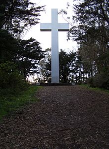
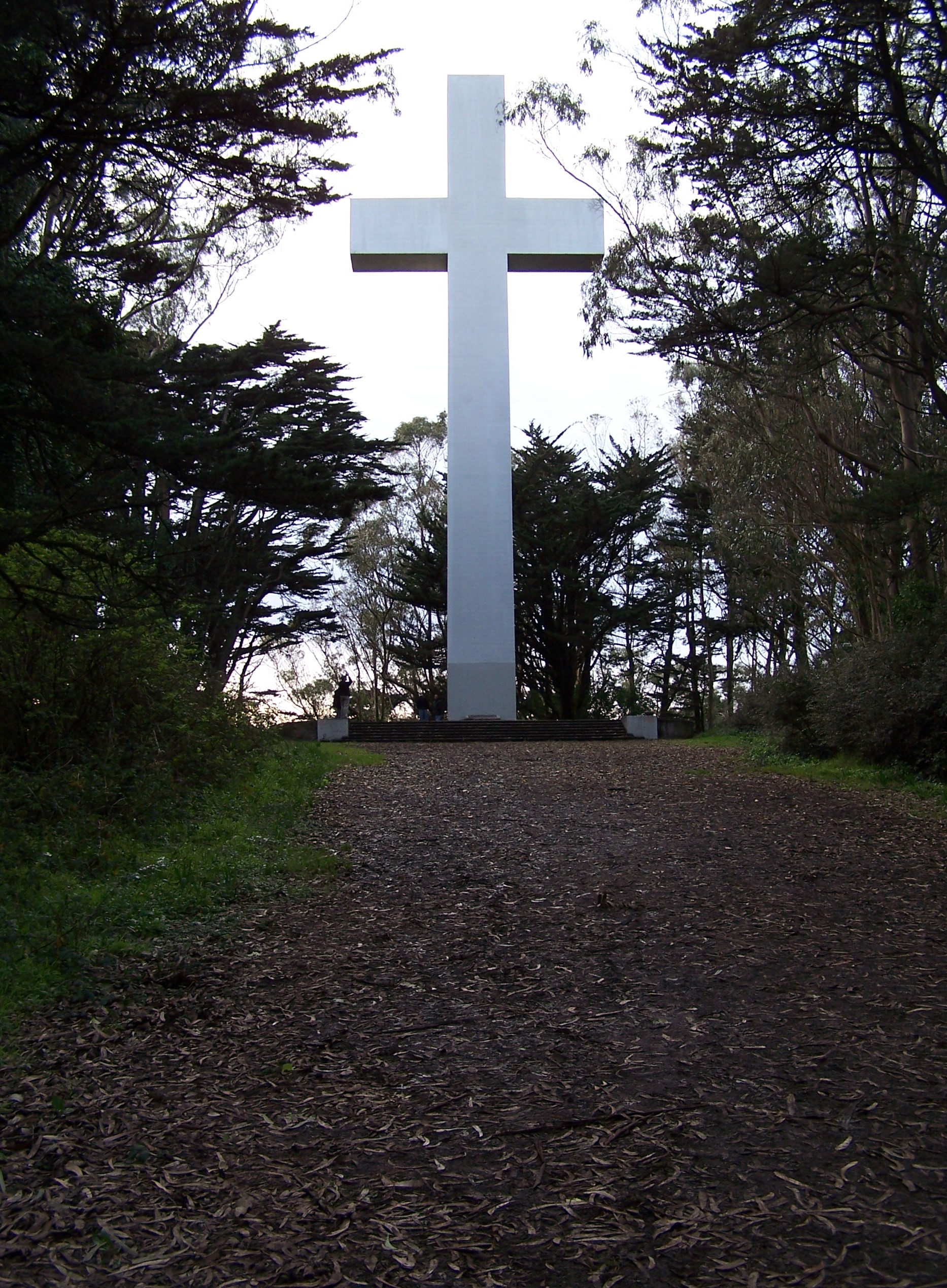
Mount Davidson's most notable feature, aside from its height, is the 103-foot (31.4 m) concrete cross situated on the crest of the hill. It is the site of a yearly prayer service, performed on Easter, when the cross is illuminated.[3]
Mount Davidson Park tops the hill - excluding the land at the summit, which is privately owned. The parkland portion is located between Myra Way (east), Dalewood Way (southwest) and Juanita Way (north). Public transportation is provided by the 36 Teresita Muni line, which stops at the Dalewood Way and Myra Way entrance to the park.
The residential neighborhoods around Mount Davidson Park are Miraloma Park, to the east, Westwood Highlands to the southwest, and Sherwood Forest, to the southwest.
Contents
History
Adolph Sutro purchased the land in 1881. Under his ownership, what was then called "Blue Mountain" was renamed "Mount Davidson," for George Davidson, a charter member of the Sierra Club. Sutro's appraiser, A.S. Baldwin, bought this land from Sutro's heirs in 1911, along with much of the land immediately north and south of Mount Davidson. Baldwin began plans for development of Forest Hill, St. Francis Wood, Westwood Park, Balboa Terrace, and Monterey Heights.
The cross
 The cross atop Mount Davidson
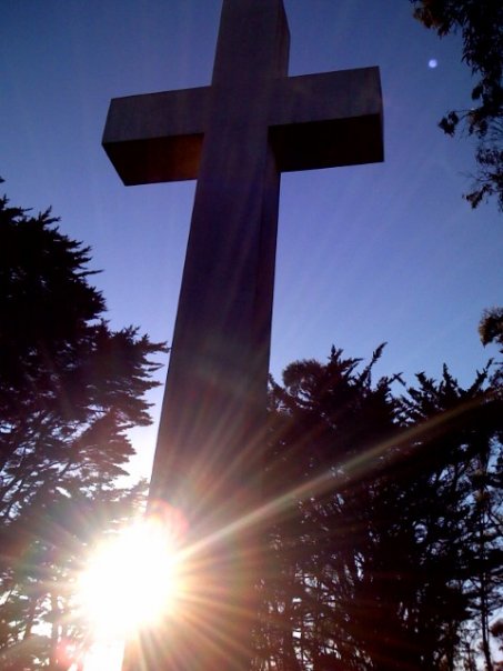
 The cross at sunset
The first temporary cross was 40 feet (12 m) high, and erected in 1923 for a service led by Dean J. Wilmer Gresham of Grace Cathedral. A second 87-foot (27 m) high cross was built in 1924 and burned down in 1925. In 1929 a 75-foot (23 m) high wood and stucco cross with lighting was built. The same year 20 acres (8.1 ha) at the top of Mount Davidson was purchased by the city of San Francisco for use as a park with funds donated by the Mount Davidson Conservation Committee, led by Mrs. Edmund N. "Madie" Brown.[4] Arsonists burned down the third cross in 1931.
In 1933 Mayor Angelo Rossi, Governor and former Mayor "Sunny Jim" James Rolph, the Easter Sunrise Service Committee, and the Native Sons of the Golden West pledged to construct a permanent cross to commemorate the early California pioneers. The 103-foot (31 m) high concrete and steel cross was completed the next year with President Franklin D. Roosevelt lighting the cross via telegraph from the White House on March 24, 1934 – eight days before Easter. Sunrise services are held at the cross every Easter and were broadcast nation-wide by CBS from the 1940s through the 1970s. (According to longtime local columnist Herb Caen, the original plans in 1934 called for a cross 100 feet (30 m) high, but there was "enough concrete on hand for an extra three feet – so on it went.")
Director Don Siegel filmed a scene from the 1971 movie Dirty Harry at the cross. Harry enters the park from Lansdale Avenue, an entry close to the Muni bus stop, before confronting Scorpio at the base of the cross. According to Warner Bros. literature, Siegel was pleased to discover the huge cross at Mount Davidson Park.[5] However, the height of the cross and foggy weather made filming difficult. Every night for a month cinematographer Bruce Surtees would ride a crane to the top of the cross only to be hampered by foggy weather. When the weather finally cleared the shot was made in one night.
The cross itself has been the subject of much debate among the residents of San Francisco as they have tried to weigh its religious role against its status as a historic landmark. In 1991 the American Civil Liberties Union, the American Jewish Congress, and Americans United for Separation of Church and State sued the city over its ownership of the cross. After a long legal battle and loss at the Ninth Circuit Court of Appeals, in 1997 the City auctioned 0.38 acres (0.15 ha) of land, including the cross, to the highest bidder.
The cross was purchased for $26,000 by The Council of Armenian American Organizations of Northern California[6] which installed a bronze plaque at the base memorializing the victims of the 1915 Armenian genocide. On Armenian Independence Day September 23, 2007, it was discovered that the 160-pound (73 kg) plaque was missing. The original plaque was never found, and a replacement plaque was dedicated at a ceremony on April 20, 2008.
See also
- Dirty Harry (1971) film directed by Don Siegel, featuring a famous scene filmed at the cross.
- List of San Francisco, California Hills
- List of highest points in California by county
References
- ^ a b c "Mount Davidson". Geographic Names Information System, U.S. Geological Survey. http://geonames.usgs.gov/pls/gnispublic/f?p=gnispq:3:::NO::P3_FID:1658377.
- ^ "Mount Davidson, California". Peakbagger.com. http://www.peakbagger.com/peak.aspx?pid=1190.
- ^ "Mt. Davidson Cross in San Francisco, California". http://www.armenian-genocide.org/popup/memorials_view.html?MemImage=112. Retrieved 2010-01-18.
- ^ "Madie Brown". MtDavidson.org. http://www.mtdavidson.org/madie_brown. Retrieved 2010-09-26.
- ^ Clint Eastwood Dirty Harry (BluRay Promotional Literature) Warner Bros Entertainment Inc 2008
- ^ "Council of Armenian Organizations of Northern California". http://www.mtdavidson.org/council_of_armenian_american_organizations_of_northern_california. Retrieved 2010-01-18.
External links
- MtDavidson.org History of Mount Davidson Cross and Neighborhoods
- Armenian Genocide
- History of Mount Davidson
Neighborhoods of San Francisco, California Downtown Chinatown · Civic Center · Financial District · Mid-Market · Nob Hill · North Beach · Mission Bay · South of Market · Telegraph Hill · Tenderloin · Union Square
North of Downtown Cow Hollow · Fisherman's Wharf · Marina District · Pacific Heights · Presidio · Russian Hill · Treasure Island · Yerba Buena Island
Outside Lands Forest Hill · Ingleside · Ingleside Terraces · Ocean View · Parkside · Richmond · Sea Cliff · St. Francis Wood · Sunset District · West Portal · Westwood Highlands · Westwood Park
Western Addition Alamo Square · Anza Vista · Cathedral Hill · Cole Valley · Corona Heights · Duboce Triangle · Fillmore · Haight-Ashbury · Hayes Valley · Japantown · Laurel Heights · Lower Haight · Pacific Heights · Presidio · Western Addition
Southern Bayview-Hunters Point · Bernal Heights · Castro · Crocker-Amazon · Diamond Heights · Dogpatch · Eureka Valley · Excelsior District · Glen Park · Mission District · Noe Valley · Outer Mission · Portola · Potrero Hill · Visitacion Valley
List · Category · Portal Categories:- Hills of San Francisco, California
- Landmarks in San Francisco, California
- Mountains of the San Francisco Bay Area
- Neighborhoods in San Francisco, California
- Parks in San Francisco, California
- Armenian Genocide memorials
- Armenia–United States relations


Wikimedia Foundation. 2010.