- Dolores Park
-
Dolores Park 
Dolores ParkType Municipal (San Francisco) Location San Francisco Area 13.7 acres (5.5 ha) Created 1906 Open All year Mission Dolores Park (commonly called Dolores Park; formerly known as Mission Park) is a San Francisco, California, city park located in the neighborhood of Mission Dolores, at the western edge of the Mission District, which lies to the east of the park. To the west of the park is a hillside referred to as "Dolores Heights" or considered a part of the Castro neighborhood. Dolores Park is two blocks tall by one block wide, based on the configuration of north-south and east-west blocks in that part of San Francisco. It is bounded by 18th Street on the north, 20th Street to the south, Dolores Street to the east and Church Street to the west. The northern end of Dolores Park is located directly across the street from Mission High School.
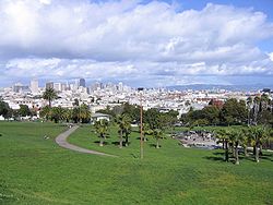
Dolores park offers several features: several tennis courts and a basketball court, a soccer field, a children's playground, and a dog play area. The southern half of the park is also notable for its views of the Mission district, downtown, the San Francisco Bay and the East Bay. Also notable is the routing of the Muni Metro J-Church streetcar line through the park.
The park lies east of Twin Peaks in the warm and sunny microclimate of the Mission neighborhood. The park is popular among San Franciscans looking for outdoor relaxation and recreation.
Contents
History
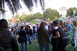
 Dolores Park during the annual Dyke March
Dolores Park is named after Mission Dolores, established by Spanish missionaries in 1776. Native Americans of the Chutchui village of the Yelamu tribe inhabited the area prehistorically before Spanish missionaries arrived.
The park site consists of two plots, Mission Blocks #86 and #87, owned by Congregation Sherith Israel and Congregation Emanu-El and was used as a Jewish cemetery which became inactive in 1894.[1] The cemetery was moved to San Mateo County when San Francisco land became too valuable for the dead and burial within the city limits was prohibited. The graves were moved to Colma (via Southern Pacific railroad), where they still rest today at Hills of Eternity and Home of Peace Cemeteries.
In 1905, the City of San Francisco bought the land of Dolores Park for $291,350 (equivalent to about $4 million in 2004).[2] In 1906-07, the park served as a refugee camp for more than 1600 families made homeless by the 1906 San Francisco Earthquake and fire.[3] Camp life after the earthquake ended in the summer of 1908. Some people kept their temporary shacks as houses and a few still survive today scattered across western San Francisco. In 1917, the J-Church streetcar line, which runs along one side of the park, began service.
Facilities
 A panoramic view of Dolores Park, from the Muni stop near Twentieth and Church Streets, with the San Francisco skyline in the distance.
Dolores Park has six tennis courts and one basketball court; two soccer fields, a playground, and a clubhouse with public restrooms. Dolores Park has been the neighborhood center for cultural, political and sports activities since the 1960s. It has hosted political rallies, festivals, Aztec ceremonial dances, Cinco de Mayo celebrations, and San Francisco Mime Troupe performances.
In 2010, it was announced that the park is to be closed throughout 2011 as part of massive renovations and a construction of a new playground.[4]
Geography and territories
Dolores Park is a community of territories and cultures that are designated by location within the park. The park is divided into Northern and Southern hemispheres by a walkway that stems from 19th St. running East to West.[citation needed]
See also
External links
- Dolores Park Historic Resource Evaluation
- Mission Dolores Neighborhood Association
- Dolores Heights Improvement Club
- Dolores Park View
- "History of Dolores Park," a photo slideshow from The Bay Citizen, a nonprofit Bay Area news site
References
- ^ SAN FRANCISCO (CALIF.). (1909). Real estate owned by the city and county of San Francisco and historical data relatin to same, with citations from decisions of the Superior, Supreme and federal courts, in relation to land titles vested in the municipality.. pp. 101. http://books.google.com/books?id=VfcsAAAAYAAJ&dq=san%20francisco%20%22Mission%20Park%22&pg=PA101#v=onepage&q=san%20francisco%20%22Mission%20Park%22&f=false. Retrieved 2009-09-05.
- ^ "The San Francisco Call newspaper October 15, 1904 page 1 - The Library of Congress". http://chroniclingamerica.loc.gov/lccn/sn85066387/1904-10-15/ed-1/seq-1/. Retrieved 2009-09-05.
- ^ "History of Dolores Park, a Bay Citizen photo slideshow". http://www.baycitizen.org/history/story/history-dolores-park-slideshow/. Retrieved 2010-10-22.
- ^ Chua, Kimberly (2010-02-03). "Dolores Park Will Close". The San Francisco Chronicle. http://www.sfgate.com/cgi-bin/blogs/inthemission/detail?entry_id=56554&o=1&rv=1265244245378>a=commentslistpos#commentslistpos.
City and County of San Francisco Government City Hall · Mayor · Board of Supervisors · San Francisco consulates · Arts Commission · Fire Department · Library · Municipal Transportation Agency (SFMuni & Parking and Traffic) · Police Department · Sheriff's Department · Jails · Port of San Francisco · Public Utilities Commission · Water Department · San Francisco Unified School District · Sister cities · SF City ID Card · District Attorney · City Attorney · San Francisco Human Rights Commission

Outlying areas Parks Alamo Square · Balboa Park · Buena Vista Park · Candlestick Point · Corona Heights Park · Dolores Park · Glen Canyon Park · Golden Gate National Recreation Area · Golden Gate Park · Grand View Park · Lincoln Park · Lake Merced · McLaren Park · Mountain Lake Park · Panhandle · Pioneer Park/Coit Tower · The Presidio · San Francisco Maritime · Stern Grove · South Park · Sutro Heights Park · Washington Square Park · Yerba Buena Gardens
Coordinates: 37°45′30″N 122°25′39″W / 37.75833°N 122.4275°W
Categories:- Municipal parks in California
- Parks in San Francisco, California
- Mission District, San Francisco, California
Wikimedia Foundation. 2010.

