- Dogpatch, San Francisco
-
Dogpatch — Neighborhood of San Francisco — 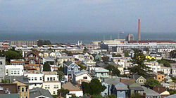 Location within Central San Francisco
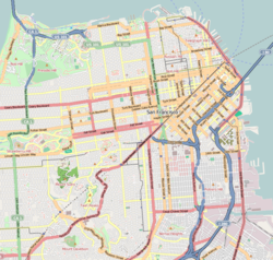
 Dogpatch
Coordinates: 37°45′38″N 122°23′28″W / 37.76060°N 122.39107°W Government - Board of Supervisors Malia Cohen - State Assembly Tom Ammiano (D) - State Senate Mark Leno (D) - U.S. House Nancy Pelosi (D) Area[1] - Total 0.6 km2 (0.221 sq mi) - Land 0.6 km2 (0.221 sq mi) Population (2008)[1] - Total 828 - Density 1,448.3/km2 (3,751/sq mi) ZIP Code 94107 Area code(s) 415 Dogpatch is a neighborhood in San Francisco, California.
Contents
Location
Dogpatch is located on the eastern side of the city, adjacent to the waterfront of San Francisco Bay, and to the east of, and below, Potrero Hill. Its boundaries are Mariposa Street to the north, I-280 to the west, Cesar Chavez to the south, and the waterfront to the east. It contains housing, some remaining heavy industry, more recent light industry, and a new but growing arts district. In 2002 it became an officially designated historic district of the city of San Francisco.[2]
History
Because it survived the 1906 earthquake and fire relatively undamaged, and until recently had not been redeveloped, Dogpatch has some of the oldest houses in San Francisco, dating from the 1860s.[2] Between the 1860s and 1880s, the marshes at the edge of the bay were filled, and the area was connected to the main part of the city by means of bridges across what was then Mission Bay (which has since been filled in). Located nearby was the (now-defunct) working-class neighborhood of Irish Hill. This permitted development of industry and housing. Waterfront-oriented industry, including shipbuilding, drydocks and ship outfitting and repairs, warehouses, steel mills, and similar industries flourished until after World War II, when they began to decline.
Dogpatch endured several decades of decline, which lasted until the 1990s, when economic pressures led to modest gentrification of the existing housing stock, and new construction including loft-style condominiums, many of which were designated as "live-work" units for artists, graphic designers, and similar occupations. The conversion of existing industrial space to live-work units or other housing has been controversial.
Attractions and characteristics
The main commercial artery of Dogpatch is Third Street, which contains retail and service businesses and is served by the T-line Third Street light rail line operated by the San Francisco Municipal Railway. The Third Street corridor connects Dogpatch to San Francisco's downtown, via new development zones including Mission Bay and the UCSF research campus.
Notable sites in the neighborhood include Irving M. Scott School, the oldest public school building in San Francisco, built 1895; the historic shipyards at Pier 70; a boxing gym, where many local amateurs train; a number of restaurants; the headquarters of the San Francisco Chapter of Hells Angels; and numerous historical residences.
References
- ^ a b [1]
- ^ a b Brody, Meredith (April 16, 2008), "Chow in Dogpatch", SF Weekly, http://sfweekly.com/2008-04-16/dining/chow-in-dogpatch/
External links
- Dogpatch Home Page
- Dogpatch's balancing act
- Dogpatch Neighborhood Association
- New York Times - Surfacing - San Francisco, Way Out East
- Street date: Third Street, San Francisco
Neighborhoods of San Francisco, California Downtown Chinatown · Civic Center · Financial District · Mid-Market · Nob Hill · North Beach · Mission Bay · South of Market · Telegraph Hill · Tenderloin · Union Square
North of Downtown Cow Hollow · Fisherman's Wharf · Marina District · Pacific Heights · Presidio · Russian Hill · Treasure Island · Yerba Buena Island
Outside Lands Forest Hill · Ingleside · Ingleside Terraces · Ocean View · Parkside · Richmond · Sea Cliff · St. Francis Wood · Sunset District · West Portal · Westwood Highlands · Westwood Park
Western Addition Alamo Square · Anza Vista · Cathedral Hill · Cole Valley · Corona Heights · Duboce Triangle · Fillmore · Haight-Ashbury · Hayes Valley · Japantown · Laurel Heights · Lower Haight · Pacific Heights · Presidio · Western Addition
Southern Bayview-Hunters Point · Bernal Heights · Castro · Crocker-Amazon · Diamond Heights · Dogpatch · Eureka Valley · Excelsior District · Glen Park · Mission District · Noe Valley · Outer Mission · Portola · Potrero Hill · Visitacion Valley
List · Category · Portal Coordinates: 37°45′38″N 122°23′28″W / 37.76060°N 122.39107°W
Categories:- Neighborhoods in San Francisco, California
- Warehouse districts of the United States
- Economy of San Francisco, California
- San Francisco County, California geography stubs


Wikimedia Foundation. 2010.