- Moraga Adobe
-
Moraga Adobe


Nearest city: Orinda, California Coordinates: 37°50′36″N 122°9′9″W / 37.84333°N 122.1525°WCoordinates: 37°50′36″N 122°9′9″W / 37.84333°N 122.1525°W Architect: Joaquin Moraga Architectural style: Mud Adobe Governing body: Private NRHP Reference#: 72000223
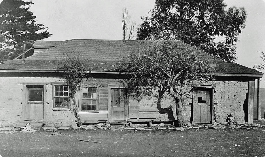
[1]Added to NRHP: March 16, 1972 The Moraga Adobe, is located at 24 Adobe Lane in Moraga, California. It was built by Don Joaquin Moraga who was the grandson of Jose Joaquin Moraga an early Spanish explorer in California who founded the city of San Jose, California In 1835, Mexico granted 13,326 acres, El Rancho Laguna de los Palos Colorados, to Joaquin Moraga and his cousin Juan Bernal. Six years later in 1841, Joaquin built this house, which is the oldest of the five surviving adobe house in Contra Costa County. The adobe sits on a knoll at the center of the 20-acre property of whats left of the once 13,000 acre grant. The house has been restored and remodeled twice since it was photographed for HABS, first in 1941 when Katharine Brown White Irvine of Oakland, California purchased the old adobe, making additions such as adding three bedrooms and a veranda, and covering the adobe walls and again in 1964 when it was incorporated into a private home. The house is not accessible to the public and it is fenced off. However, it was photographed in 1922 for the Historical American Building Survey (HABS). Today, the Moraga Adobe is privately owned and unoccupied. The overall condition of the original adobe section and the more modern addition is neglected, but the building appears sound. The surrounding property was recently purchased, and the new owners have boarded up the windows to prevent vandalism and tresspassing. The Moraga Adobe has been designated as a Historical Landmark by the City of Orinda and the State of California
See also
References
- ^ "National Register Information System". National Register of Historic Places. National Park Service. 2011a. http://nrhp.focus.nps.gov/natreg/docs/All_Data.html.
External links
U.S. National Register of Historic Places Topics Lists by states Alabama • Alaska • Arizona • Arkansas • California • Colorado • Connecticut • Delaware • Florida • Georgia • Hawaii • Idaho • Illinois • Indiana • Iowa • Kansas • Kentucky • Louisiana • Maine • Maryland • Massachusetts • Michigan • Minnesota • Mississippi • Missouri • Montana • Nebraska • Nevada • New Hampshire • New Jersey • New Mexico • New York • North Carolina • North Dakota • Ohio • Oklahoma • Oregon • Pennsylvania • Rhode Island • South Carolina • South Dakota • Tennessee • Texas • Utah • Vermont • Virginia • Washington • West Virginia • Wisconsin • WyomingLists by territories Lists by associated states Other Categories:- Historic districts in California
- History of Contra Costa County, California
- National Register of Historic Places in the San Francisco Bay Area
- Antioch, California
- Houses on the National Register of Historic Places in California
- Contra Costa County, California geography stubs

Wikimedia Foundation. 2010.