- U.S. Route 24 in Colorado
-
This article is about the section of U.S. Route 24 in Colorado. For the entire length of the highway, see U.S. Route 24.
U.S. Route 24
Route information Maintained by CDOT Length: 323.241 mi[2] (520.21 km) Existed: 1936[1] – present Major junctions West end: 
 I-70 / US 6 in Minturn
 US 285 in Buena Vista


 I-25 / US 85 / US 87 in Colorado Springs

 I-70 / US 40 / US 287 in Limon
 US 385 in Burlington
I-70 from Burlington to Kansas state lineEast end: 
 I-70 / US-24 near Burlington
Highway system United States Numbered Highways
List • Bannered • Divided • Replaced←  SH 23
SH 23I-25 →U.S. Route 24 is a major east–west route in the U.S. state of Colorado.
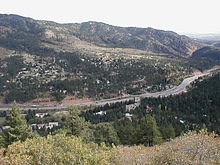 U.S. Route 24 near Woodland Park, Colorado, viewed from Pike's Peak
Route description
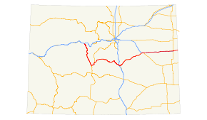
It traverses the Rocky Mountains, starting near Minturn. It then continues east for about 30 miles Leadville where it turns south and goes to Buena Vista where it becomes concurrent with US 285. It continues with Highway 285 to the small community of Antero Junction. After that, it spends its time as a mountainous two-lane highway through the town of Divide, where it meets SH 67. These highways overlap to Woodland Park. From there it passes through Crystola, Green Mountain Falls, Cascade as a 4-lane highway. Through Manitou Springs and Colorado Springs, where the road is known as Midland Expressway. It goes through the Springs and then continues northeast through several towns such as Falcon, Peyton, the city of Calhan, Ramah, Simla, and Matheson. When US 24 reaches Limon, it junctions with I-70/US 40/US 287/SH 71. It continues east (parallel to I-70) to Burlington where it joins I-70 to the Kansas state line.
Junction list
County Location Mile[2] Destinations Notes Eagle Minturn 0.000 I-70 / US 6 – Denver, Grand JunctionWestern terminus of US 24 Lake Leadville 31  SH 91 north
47  SH 82 west – Aspen
Chaffee Johnson Village 68.5 US 285 south – Poncha SpringsSouthern end of US 285 overlap Park 82 US 285 north – FairplayNorthern end of US 285 overlap Hartsel 94  SH 9 north – Fairplay
Teller Divide 132  SH 67 south – Cripple Creek, Victor
Western end of SH 67 overlap Woodland Park 139.5 SH 67 north – DeckersEastern end of SH 67 overlap 145 Pikes Peak Highway El Paso Manitou Springs 150 
US 24 Bus. east / Manitou Avenue153
US 24 Bus. west / Manitou AvenueColorado Springs 158 I-25 north – DenverNorthern end of I-25 overlap 159  SH 115 south / Nevada Avenue, Tejon Street
I-25 exit 140 160 I-25 south – PuebloSouthern end of I-25 overlap 161.5 Union Boulevard 163  SH 29 / Circle Drive
Western end of Fountain Blvd overlap 164.5  SH 83 / Academy Boulevard – Security-Widefield, Black Forest
167  SH 21 south / Powers Boulevard –
  Colorado Springs Municipal Airport
Eastern end of Fountain Blvd overlap
Southern end of SH 21/Powers Blvd overlap168 Airport Road east – Peterson Air Force Base 169 SH 21 north / Powers BoulevardNorthern end of SH 21/Powers Blvd overlap 169 Platte Avenue west – Downtown Colorado Springs 169.5 Peterson Road south – Peterson Air Force Base 169.5  To SH 94 east / Space Village Avenue
170.5 SH 94 east – Schriever Air Force Base, Colorado Springs East Airport, Punkin CenterFalcon 178 Woodmen Road 180 Judge Orr Road east – Meadow Lake Airport 183  To SH 86/Elbert Road – Elbert, Kiowa
Peyton 188 Peyton Highway 192 Ellicott Highway Calhan 198 Calhan Highway Elbert Simla 211 County Road 125 Connect to SH 86 Matheson 218 County Road 149 Lincoln Limon 230  US 40/US 287 north – Denver, SH 71 south – Punkin Center
Western end of US 40/287/SH 71 overlap 232 SH 71 north – Last ChanceEastern end of SH 71 overlap 233 I-70 – Denver, Burlington234 I-70 east – Burlington, US 40/US 287 south – Kit CarsonEastern end of US 40/287 overlap, western end of I-70 overlap Kit Carson Seibert 277 I-70 east – BurlingtonEastern overlap of I-70 277.5  SH 59 – Yuma, Kit Carson
Stratton 293  SH 57 north
Burlington 309 US 385 south (Lincoln Street) – Cheyenne WellsWestern end of US 385 overlap 310 US 385 north – WrayEastern end of US 385 overlap 310.5 I-70 west – LimonWestern end of I-70 overlap 318 I-70 east / US-24 – GoodlandKansas state line; Eastern terminus of US 24 in Colorado 1.000 mi = 1.609 km; 1.000 km = 0.621 mi References
- ^ Salek, Matthew E.. "Colorado Routes 20-39". http://www.mesalek.com/colo/r20-39.html#us24. Retrieved 12-31-2010.
- ^ a b Colorado Department of Transportation, Highway Data, accessed July 2008
U.S. Route 24Previous state:
TerminusColorado Next state:
KansasCategories:- U.S. Route 24
- U.S. Highways in Colorado


Wikimedia Foundation. 2010.