- Woodland Park, Colorado
Infobox Settlement
official_name = City of Woodland Park, Colorado
other_name =
native_name =
nickname = The city above the clouds
settlement_type =City
motto =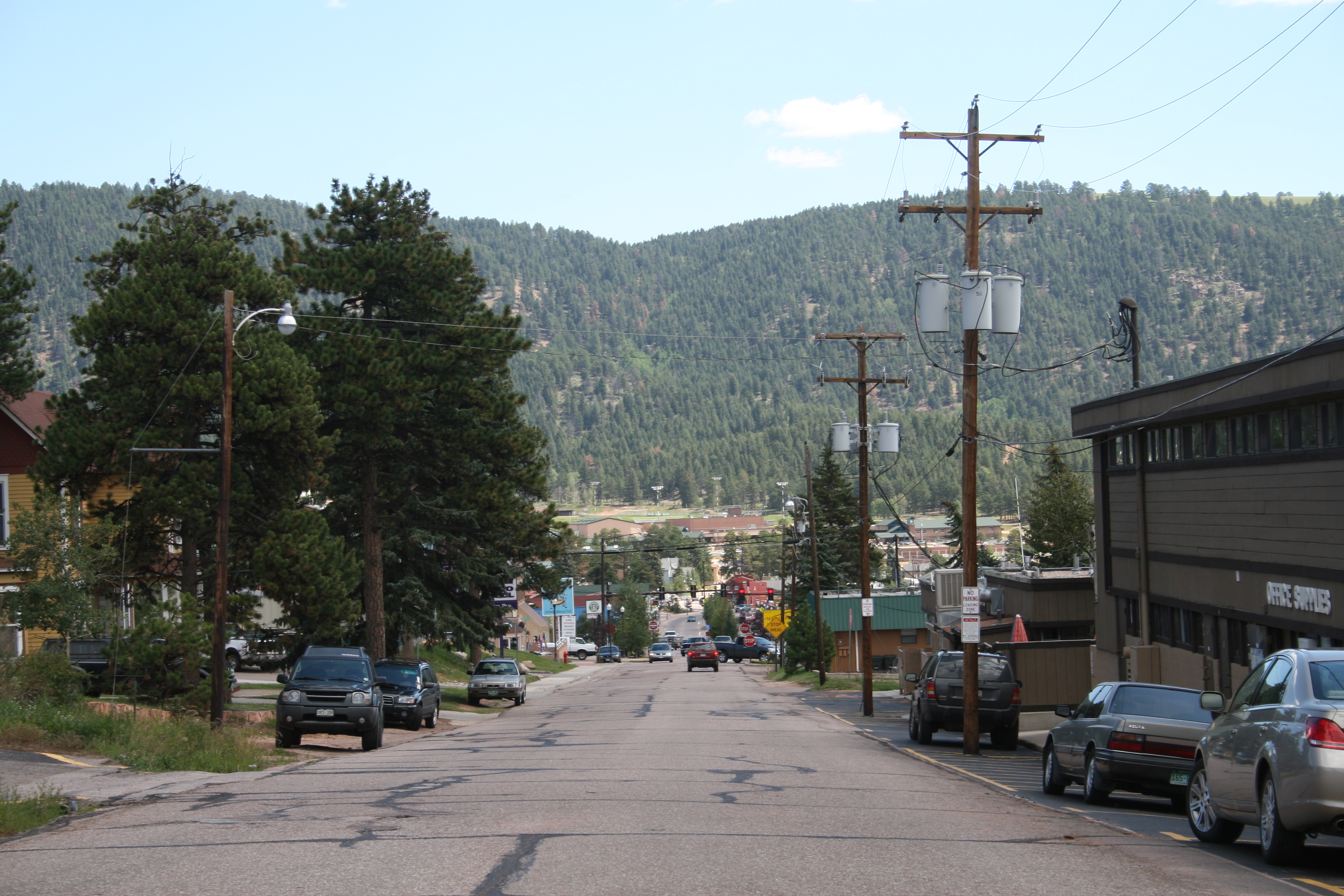
imagesize =
image_caption = Western and downtown Woodland Park, seen from east of Highway 67. Woodland Park High School and part of thePike National Forest can be seen in the distance.
flag_size =
image_
seal_size =
image_shield =
shield_size =
image_blank_emblem =
blank_emblem_type =
blank_emblem_size =
flag_size =
image_
seal_size =
image_shield =
shield_size =
image_blank_emblem =
blank_emblem_type =
blank_emblem_size =
mapsize = 250px
map_caption = Location in Teller County and the state ofColorado
mapsize1 =
map_caption1 =
image_dot_
dot_mapsize =
dot_map_caption =
dot_x =
dot_y =
pushpin_
pushpin_label_position =
pushpin_map_caption =
pushpin_mapsize =
subdivision_type = Country
subdivision_name = USA
subdivision_type1 = State
subdivision_name1 = flag|Colorado
subdivision_type2 = Countycite web | url = http://www.dola.state.co.us/dlg/local_governments/municipalities.html | title = Active Colorado Municipalities | format =HTML | publisher = State of Colorado, Department of Local Affairs | accessdate = 2007-09-01]
subdivision_name2 = Teller County
subdivision_type3 =
subdivision_name3 =
subdivision_type4 =
subdivision_name4 =
government_footnotes =
government_type = Home Rule Municipality
leader_title =Mayor
leader_name = Steve Randolph [cite web
last =
first =
authorlink =
coauthors =
title = Woodland Park City Council
work =
publisher = City of Woodland Park
date =
url = http://www.city-woodlandpark.org/department/citycouncil.php
format =
doi =
accessdate = 2007-08-14]
leader_title1 =
leader_name1 =
leader_title2 =
leader_name2 =
leader_title3 =
leader_name3 =
leader_title4 =
leader_name4 =
established_title =
established_date =
established_title2 =
established_date2 =
established_title3 = Incorporated
established_date3 =June 6 ,1891 cite web | url = http://www.colorado.gov/dpa/doit/archives/muninc.html | title = Colorado Municipal Incorporations | format =HTML | publisher = State of Colorado, Department of Personnel & Administration, Colorado State Archives | date =2004-12-01 | accessdate = 2007-09-02]
area_magnitude =
unit_pref = Imperial
area_footnotes =
area_total_km2 = 14.7
area_land_km2 = 14.7
area_water_km2 = 0
area_total_sq_mi = 5.7
area_land_sq_mi = 5.7
area_water_sq_mi = 0
area_water_percent =
area_urban_km2 =
area_urban_sq_mi =
area_metro_km2 =
area_metro_sq_mi =
area_blank1_title =
area_blank1_km2 =
area_blank1_sq_mi =
population_as_of = 2000
population_footnotes =
population_note =
population_total = 6515
population_density_km2 = 443.2
population_density_sq_mi = 1143
population_metro =
population_density_metro_km2 =
population_density_metro_sq_mi =
population_urban =
population_density_urban_km2 =
population_density_urban_sq_mi =
population_blank1_title =
population_blank1 =
population_density_blank1_km2 =
population_density_blank1_sq_mi =
timezone = MST
utc_offset = -7
timezone_DST = MDT
utc_offset_DST = -6
latd = 38 |latm = 59 |lats = 54 |latNS = N
longd = 105 |longm = 3 |longs = 23 |longEW = W
elevation_footnotes =
elevation_m =
elevation_ft = 8465
postal_code_type =ZIP code cite web|url = http://zip4.usps.com/zip4/citytown.jsp | title = ZIP Code Lookup| format =JavaScript /HTML | publisher =United States Postal Service | accessdate=2008-01-10]
postal_code = 80863, 80866 (PO Box)
area_code = 719
blank_name = FIPS code
blank_info = 08-86090
blank1_name = GNIS feature ID
blank1_info = [http://geonames.usgs.gov/pls/gnispublic/f?p=gnispq:3:::NO::P3_FID:0204768 0204768]
website = [http://www.city-woodlandpark.org/ City of Woodland Park]
footnotes =Woodland Park is a Home Rule Municipality that is the most populous city in Teller County,
Colorado ,United States . Many residents in thisbedroom community , which is surrounded by thePike National Forest , make the 17-mile commute to Colorado Springs.Ute Pass lies 12 miles to the west of Woodland Park on US 24. The population was 6,515 at the 2000 census. Nearby Douglas County is about a fifteen-minute drive from the city.Local notes
Called the "The City Above the Clouds" by long time resident Cal Elder, Woodland Park often enjoys clear skies while weather in neighboring towns may be rainy or overcast. The city has pursued a policy of careful growth, despite recent controversy over the construction of a
Wal-Mart franchise, and enjoys a fine view ofPikes Peak . Woodland Park offers easy access tohiking ,climbing , andfishing . Because of the city's location, there is a natural limitation to population growth. At roughly 8500 feet, Woodland Park is just beginning to recover from a long drought; the winter of 2006-2007 marked the return of what long-time residents have called "real Woodland Park weather" with daytime winter temperatures frequently plunging below freezing. However, some residents find Colorado winters more tolarable than those in other parts of the country, with blue skies and warm days peppered throughout the season.A number of full-time musicians reside in Woodland Park and the surrounding areas, and
arts festival s have become more frequent in recent years, often held at theUte Pass Cultural Center . Woodland Park is also the site of theRocky Mountain Dinosaur Resource Center , a museum devoted todinosaur s andfossil s.Clint Vahsholtz , an ARCA driver, is a notable resident of the city.Gardening
Due to the long winters and short growing season many local gardeners utilize greenhouses and irrigation to grow delicious organic vegetables.
Crime
On
January 20 ,2001 , the owner of the Coachlight Motel and R.V. Park discovered that theTexas 7 , a group of escaped prisoners also wanted for robbery and murder, were hiding out, living in an RV on his property. The next day, onJanuary 21 , SWAT teams found five of the members in and near the park. One shot himself; the other four were arrested. [cite web|url=http://archives.cnn.com/2001/US/01/22/texas.escapees.03/index.html|title=FBI searching for 2 Texas escapees still on the loose|publisher=CNN|date=2001-01-22|accessdate=2007-06-28]Geography
Woodland Park is located at coor dms|38|59|54|N|105|3|23|W|city (38.998226, -105.056269)GR|1, at the eastern intersection of U.S. Highway 24 and State Highway 67. (The highways overlap west to Divide.)
According to the
United States Census Bureau , the city has a total area of 5.7square mile s (14.7km² ), all of it land.Demographics
As of the
census GR|2 of 2000, there were 6,515 people, 2,476 households, and 1,884 families residing in the city. Thepopulation density was 1,151.0 people per square mile (444.4/km²). There were 2,642 housing units at an average density of 466.8/sq mi (180.2/km²). The racial makeup of the city was 94.89% White, 0.52% African American, 0.72% Native American, 0.87% Asian, 0.81% from other races, and 2.18% from two or more races. Hispanic or Latino of any race were 3.45% of the population.There were 2,476 households out of which 39.9% had children under the age of 18 living with them, 65.3% were married couples living together, 7.7% had a female householder with no husband present, and 23.9% were non-families. 19.1% of all households were made up of individuals and 4.3% had someone living alone who was 65 years of age or older. The average household size was 2.63 and the average family size was 3.03.
In the city the population was spread out with 28.5% under the age of 18, 5.8% from 18 to 24, 32.9% from 25 to 44, 26.3% from 45 to 64, and 6.5% who were 65 years of age or older. The median age was 38 years. For every 100 females there were 100.4 males. For every 100 females age 18 and over, there were 97.0 males.
The median income for a household in the city was $52,279, and the median income for a family was $59,583. Males had a median income of $36,157 versus $27,459 for females. The
per capita income for the city was $22,780. About 1.8% of families and 3.7% of the population were below thepoverty line , including 4.9% of those under age 18 and 3.7% of those age 65 or over.Students are served by
Woodland Park School District RE-2 .Notable Residents
*
Robert L. Stewart - formerastronaut [cite web
last = Roper
first = Peter
authorlink =
coauthors =
title = Ex-astronaut says NASA should be focusing on Mars
work =
publisher = The Pueblo Chieftain Online
date =
url = http://www.chieftain.com/metro/1195890474/4
format =HTML
doi =
accessdate = 2007-12-11]ee also
*
Colorado municipalities
*Colorado Springs Metropolitan Statistical Area
*Front Range Urban Corridor
*South Central Colorado Urban Area
*State of Colorado
*Teller County, Colorado References
External links
* [http://www.city-woodlandpark.org/ City of Woodland Park website]
** [http://www.dot.state.co.us/App_DTD_DataAccess/Downloads/CityMaps/Woodland%20Park.pdf CDOT map of the Town of Woodland Park]
* [http://www.woodlandparkchamber.com The Greater Woodland Park Chamber of Commerce]
* [http://www.tellerlinks.com Teller County] (County Information & Links)
* [http://www.utepasscams.com Live webcam views of Woodland Park & Pikes Peak]
* [http://www.wpsdk12.org/~WPHSWeb Woodland Park High School]
Wikimedia Foundation. 2010.