- Colorado State Highway 9
-
State Highway 9
Route information Maintained by CDOT Length: 138.92 mi[1] (223.57 km) Major junctions South end:  US 50 near Cañon City
North end:  US 40 in Kremmling
Location Counties: Fremont, Park, Summit, Grand Highway system ←  SH 8
SH 8SH 10  →
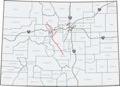
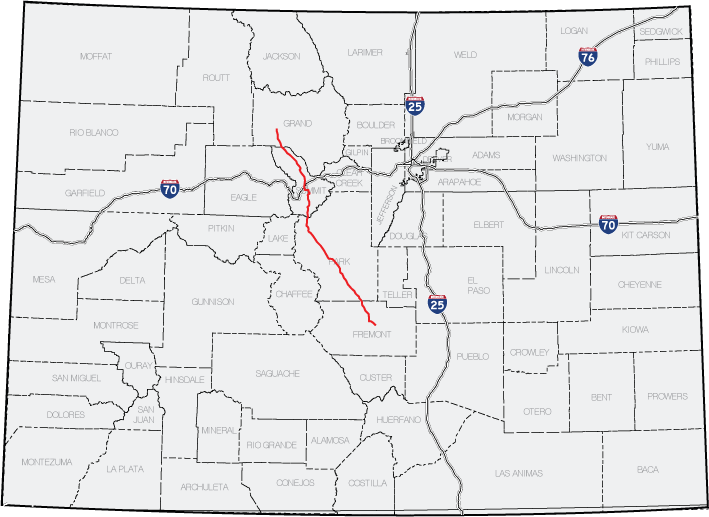
→State Highway 9 in the U.S. state of Colorado is a 138-mile (222 km) long state highway through central Colorado.
Route description
State Highway 9 starts at a junction with US 50 west of Cañon City. It heads northwest, following Currant Creek most of the way to Currant Creek Pass where it enters an open area known as South Park. The south fork of the South Platte is crossed as the highway enters Hartsel and a junction with US 24. SH 9 follows US 24 west for 0.5 mi (0.80 km), then splits off to head northwest again. Just south of Fairplay, it joins northbound US 285. At Fairplay SH 9 leaves US 285 to head northwest, following the middle fork of the South Platte most of the way to Hoosier Pass where it crosses the Continental Divide 11,532 ft (3,515 m) above sea level. Switchbacks drop the highway to the Blue River which it follows north through Breckenridge to Dillon Reservoir. The highway goes around the west side of the reservoir, through Frisco and joins I 70 as it heads northeast. At Silverthorne, SH 9 leaves I 70 to continue northwest alongside the Blue River. SH 9 crosses the Colorado River just before it's termination at a junction with US 40 in Kremmling.[2]
Major intersections
County Location Mile Destination Notes Fremont 0.000 US 50Park Hartsel 46.980  US 24
US 24Begin concurrency 47.582 US 24End concurrency 63.732  US 285
Begin concurrency Fairplay 64.673 US 285End concurrency Summit Frisco 96.998  I-70
I-70Begin concurrency Silverthorne 101.562 I-70End concurrency Grand Kremmling 138.920 US 401.000 mi = 1.609 km; 1.000 km = 0.621 mi References
- ^ "Segment list for SH 9". http://www.dot.state.co.us/app_DTD_DataAccess/Highways/index.cfm?fuseaction=Description&route=009&begRefPt=0&endRefPt=500&Printable=true. Retrieved 2007-05-12.
- ^ Colorado Atlas & Gazetteer (3rd ed.). Yarmouth, Maine: DeLorme. 1997. pp. 27,37,38,61. ISBN 0-89933-206-4.
Categories:- Transportation in Park County, Colorado
- Transportation in Fremont County, Colorado
- Transportation in Grand County, Colorado
- Transportation in Summit County, Colorado
- State highways in Colorado

Wikimedia Foundation. 2010.