- U.S. Route 40 in Colorado
-
This article is about the section of U.S. Route 40 in Colorado. For the entire length of the highway, see U.S. Route 40.
U.S. Route 40
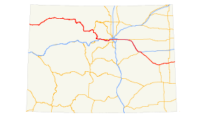
Route information Maintained by Colorado Department of Transportation Length: 496.442 mi[1] (798.946 km) Existed: 1926 – present Major junctions West end:  US-40 at Utah state line
 US 34 near Granby

 I-70 / US 6 at Empire
 SH 470 in Golden
 US 287 from Denver to Kit Carson


 I-25 / US 85 / US 87 in Denver
 I-225 in Aurora
 US 36 near Aurora
 E-470 near Aurora
I-70 from Watkins to Limon
 US 385 at Cheyenne Wells
East end: US-40 east of Arapahoe at Kansas state lineHighway system United States Numbered Highways
List • Bannered • Divided • Replaced←  SH 39
SH 39SH 41  →
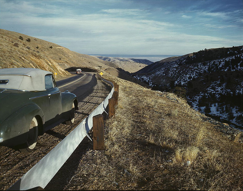
→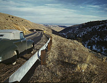 View along US 40 in Mount Vernon Canyon, Colorado, 1942. Photo by Andreas Feininger.
In the U.S. state of Colorado, U.S. Route 40 is a major east–west route. It crosses the Rocky Mountains, passing over the Continental Divide three times before reaching the front range. It then traverses through the Denver Metro Area, then exits by following I-70 and US 287. It is concurrent with US 287 for about 145 miles to Kit Carson. US 40 exits into Kansas east of Arapahoe in Cheyenne.
Contents
Route description
Entering Colorado to the south of Dinosaur National Monument, U.S. 40 runs east through the small town of Dinosaur along Brontosaurus Boulevard. The route continues a generally easterly course though Moffat and Routt counties, passing through several small communities along the way. It generally follows the course of the Yampa River. U.S. 40 becomes Lincoln Avenue as it runs through historic downtown Steamboat Springs, Colorado.
U.S. 40 crosses the Continental Divide three times on its trip through Colorado, mostly in the vicinity of Winter Park. Taking a circuitous route through Rabbit Ears Pass, Muddy Pass and Berthoud Pass it descends the escarpment along the eastern edge of the Rocky Mountains. Just to the east of Empire, it merges with Interstate 70 for the first time. US 40 and I-70 will frequently share pavement across the U.S. The route leaves I-70 at exit 244, to the west of Idaho Springs and rejoins it again at between exits 252 and 254 in El Rancho. It parallels I-70, mostly as a frontage road, until the intersection with Colorado State Highway 26 to the south of Golden[2][3]
Beginning in Golden, US 40 becomes Colfax Avenue, the main east–west thoroughfare through the Denver-Aurora Metropolitan Area. Along with US 40, the entire route along Colfax Avenue is cosigned as Business Loop 70. The route travels northeast through Golden, then turns due east to travel through Lakewood, Denver, and Aurora. Among the sights to be seen along US 40 is Lake Steam Bath, once the location of a thriving health industry centered on tuberculosis sanatoriums. Also along Colfax Avenue in Denver is the Denver branch of the United States Mint, which produces 50 million coins per day. US 40 rejoins I-70 at exit 288, just to the east of Aurora.[3][4][5]
At exit 359 in Limon, US 40 leaves I-70 along Main Street, which it shares with Business Loop 70, US 24, US 287, and SH 71. US 40/US 287 continues to the southeast to the town of Kit Carson. From there, it leaves US 287 and continues east through the towns of Cheyenne Wells and Arapahoe before entering the state of Kansas.[3][4]
Major intersections
County Location Mile[1] Destinations Notes Moffat 0.000 US-40- UtahWestern terminus of US 40 in Colorado Dinosaur 3  SH 64 south – Rangely
Maybell 59  SH 318
Craig 88.5  SH 13
SH 1389.5  SH 394 – Craig-Moffat County Airport
Routt Steamboat Springs 134 Mount Werner Road Interchange 136  SH 131
Grand 156  SH 14 east – Fort Collins
Kremmling 184  SH 9
SH 9207.5  SH 125
Granby 211 US 34 west – Estes Park, GreeleyClear Creek Empire 247 I-70 west – Grand JunctionWestern end of I-70 overlap I-70 east – DenverJefferson 266  SH 74 – Evergreen
Golden 275 SH 470 south – Colorado SpringsI-70 exit #260 Denver Denver 276 US 6 (6th Avenue)I-70 exit #261; Eastern end of I-70 overlap 279 Kipling Street 282  SH 121 (Wadsworth Boulevard)
283.5 Sheridan Boulevard 285 US 287 (Federal Blvd)Western end of US 287 overlap 286.5 I-25 / US 85 / US 87 – Fort Collins, Colorado SpringsAdams Aurora 296 I-225 – Aurora300 I-70 / US 36Western end of US 36 overlap 302 E-470-  Denver International Airport, Boulder, Colorado Springs
I-70 exit #284 314  SH 79 north – Bennett
I-70 exit #304 Arapahoe 328 US 36 east – ByersI-70 exit #316; eastern end of US 36 overlap Lincoln Limon 382 
 SH 71 / US 24 west
386 US 24 eastI-70 exit #359; eastern end of I-70 overlap Hugo 398 County Highway 109 / County Road 31 – Genoa 399 County Highway 109 / County Road 32 (3rd Ave) – Karval Cheyenne Aroya 425.5  SH 94 west – Colorado Springs
Kit Carson 445  SH 59 north – Seibert
446 US 287 south – EadsEastern end of US 287 overlap Cheyenne Wells 471 US 385487 US-40 east – KansasEastern terminus of US 40 in Colorado See also
Related U.S. Routes
- U.S. Highway 340
References
- ^ a b Colorado Department of Transportation, Highway Data, accessed July 2007
- ^ Brusca, Frank X. (2002). "US 40 Scrapbook: Colorado". U.S. Route 40: America's Golden Highway. route40.net. Archived from the original on 2007-09-27. http://web.archive.org/web/20070927203821/http://www.route40.net/scrapbook/co/index.shtml. Retrieved 2007-05-21.
- ^ a b c Salek, Matthew E. (2006). "US 40". Colorado Highways. http://www.mesalek.com/colo/us40.html. Retrieved 2007-05-22.
- ^ a b Mapsource. Garmin Ltd.. 2003.
- ^ Royston, Reggie (2001). "Denver's Road of Riches: Colfax Avenue". National Geographic News. National Geographic Society. http://news.nationalgeographic.com/news/2001/05/0501_ColfaxAveDenver.html. Retrieved 2007-05-22.
U.S. Route 40Previous state:
UtahColorado Next state:
KansasCategories:- U.S. Route 40
- U.S. Highways in Colorado


Wikimedia Foundation. 2010.