- Chuadanga District
-
Chuadanga
চুয়াডাঙা— District — Location of Chuadanga in Bangladesh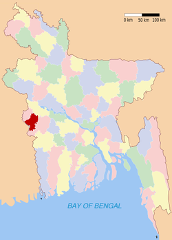
Coordinates: 23°36′N 88°42′E / 23.60°N 88.70°ECoordinates: 23°36′N 88°42′E / 23.60°N 88.70°E Country  Bangladesh
Division Khulna Division Area - Total 1,157.42 km2 (446.9 sq mi) Population (1991) - Total 987,382 - Density 853.1/km2 (2,209.5/sq mi) Literacy rate - Total 25.2% Time zone BST (UTC+6) - Summer (DST) BDST (UTC+7) Website Banglapedia Article Chuadanga (Bangla: চুয়াডাঙা; Chuađaņa), Chuadanga district or Chuadanga Zilla (চুয়াডাঙা জেলা) is the name of a Western district (zilla) of Bangladesh. It is a part of the Khulna administrative division that covers most districts in the south-west of the country.
Contents
History
According to Greek historians, as well as from geographical formations, this region formed a part of the kingdom of Gangaridhi. A city by the name of Gangey is also thought to be located in this region.
During British rule, the region was the location of several uprisings, including Wahabi Movement (1831), Faraizi Movement(1838–47), Sepoy Rebellion (1857), Indigo Rebellion (1859–60), Khilafat Movement (1920), Swadeshi Movement (1906), Non-cooperation movement, Violation of Law and Salt Satyagraha (1920–40), Quit India Movement or August Revolt (1942).
Under British rule, Chuadanga was a sub-division within Nadia District. During partition, in 1947, excepting Krishnanagar thana (still under Nadia in West Bengal), the whole territory of Chuadanga sub-division was included in Kushtia District.
During Bangladesh Liberation War of 1971, Chuadanga was the location of some early battles between the Pakistan Army and the Mukti Bahini pro-independence forces. More than 100 battles took place here. On 26 March 1971, the first war command, the South Western Command of Bangladesh, was set up in this area, under the leadership of Major Abu Osman Chowdhury and Dr. Ashabul Haque Joarder (expired at 89 on 7 October 2010). Before that at about 09:30 in the morning of the same day in a makeshift public meeting arranged at Borobazar crossing, Dr. Ashabul Haque Joarder declared all out war against the occupation of Pakistan military forces. This region was also the place where Bangladesh Red Cross Society was founded. During the liberation war the government in exile declared Chuadanga to be the provisional capital of the People's Republic of Bangladesh. During the Bangladesh Liberation War more than one hundred documented direct encounters took place between the Pakistan Army and the freedom fighters (Mukti Bahini) in Chuadanga district. According to records Chuadanga was liberated from the hands of occupying Pakistan army on 7 December 1971, nine days before the invading army officially surrendered to the Mitro Bahini (allied forces of Mukti Bahini and Indian Army).[1]
Marks of the Liberation War genocide in the district include a spot behind the Chuadanga Central Hospital, three mass graves at places on the back of the Natudaha High School, at village Dhopakhali near the Jibannagar border and on the bank of GK Canal near Alamdanga Railway Station.[citation needed] Two memorial monuments stand today in memory of the war.[1]
Chuadanga was separated from Kushtia and given the status of a district in 1984.
Chuadanga (Town) stands on the bank of the river Mathabhanga. It consists of 9 wards and 41 mahallas. It is "A" graded municipal town. Though established in 1960, it started functioning in 1965. The town has an area of 36.12 km². It has a population of 72081; male 50.13%, female 49.87%. Literacy rate among the town people is 100%.
Geography
The district has an area of 1,157.42 (km)². It shares domestic borders with the Kushtia District on the northeast, Meherpur on the northwest and Jhenaidaha on the south and southeast. On its southwest lies the Nadia District (in the state of West Bengal in India).
The main township of Chuadanga lies on the bank of River Mathabhanga. The annual average maximum temperature is 40.1 °C and the average for the minimum is 8.2 °C, while 1,467 mm is received on average each year.
The entire Chuadanga district lies within the Ganges Delta, with rivers Mathabhanga, Bhairab, Kumar, Chitra, and Nabaganga flowing through the district.
Administration
Until the Partition of India in 1947 Chuadanga sub-division was within Nadia district, at partition, excepting Krishnagar thana, the whole territory of Chuadanga sub-division was included in Kushtia district. It was turned into a district in 1984. The district consists of 5 municipalities, 36 wards, 93 mahallas, 4 upazilas, 31 union parishads, 421 mouzas and 514 villages. Municipalities are Chuadanga Sadar, Alamdanga, Damurhuda and Jibannagar and Darsana. Of these municipalities, all but the last also have upazila status.
The entire district has two representatives Member of Parliament to the National Assembly of Bangladesh. The Government appoints one Deputy Commissioner, DC, for the entire district.
The current Deputy Commissioner of Chuadanga is Mr. Bholanath Dey where as Mr. Sulaiman Haq Jowarder Selun and Mr. Ali Ajgor Togor remains as the Member of Parliament of this district.
Demographics
The population of the district was 987,382 during the 2001 national survey with 50.82% male and female 49.18% compositions.
Religion
The district of Chuadanga consists 3554 mosques, 218 temples, 13 churches and three Buddhist temples.
Researchers/Academics from Chuadanga District
- Dr. Mahabub Hossain - Executive Director of BRAC
- Dr. Mohammad Alauddin - Academic at the University of Queensland, Australia
- Dr. Asadul Haque - Academic, Monash University, Australia
- Dr. Nawshadul Haque - Scientist at CSIRO, Australia
- Dr. Md Habibur Rahman (Habib), Senior Engineer, Intel Corporation, USA
Education
Average literacy rate is 25.2%, with a sizeable gap between male and female literacy rates at 30.5% and 19.6% respectively.
The different kinds of educational institutions are as follows:
- Colleges - 12
- High schools - 48
- Junior schools - 7
- Government Primary schools - 257
- Non-government Primary schools - 120
- Primary Training institute - 1
- Vocational Training institute 1
- Nursing institute 1
- Madrasas - 63
- Kindergarten schools - 3
- English medium school -2
Noted old educational institutions include the Victoria Jubilee Government High School (est. 1880), Alomdaņga pilot High School (est. 1914), Natudaôho High School (est. 1906),Carew's High School(1947), Gokulkhali High School ( est. 1947), Jibonnôgor Pilot High School (est. 1957),damurhuda pilot high school and Hajar Duari School.
According to the SSC (Secondary School Certificate) result some schools are really doing better. Among these Carew's High School, Victoria Jubilee High School,Government Girls' School and Nilmonigônj High School are mentionworthy. Are also Secondary Name: "BISHNUPUR SECONDARY SCHOOL" Is establish 1964 & Damurhuda upojila
Economy
Most of this small district is dedicated to agriculture. Occupational distributions clearly show this with agriculture employing 68% of the labour force, while only 12% are involved in commerce. Total cultivable land amounts to 894.20 km², of which 57% is under some sort of irrigation.
Besides agriculture the district is now experiencing industrial growth. Major industries include Zaman Group of Industries, Bangas bread and biscuit, Tallu Spinning mills Ltd,Carew & Company Bangladesh Limited etc.Carew & Company Bangladesh Limited(1933),which is situated at Darshana of Damurhuda Upazilla of Chuadanga district is the largest sugar mill of Bangladesh,Carew & Company has a distillery also which is the lone wine producing plant of Bangladesh ,Carew & Company Bangladesh Limited is an enterprise of Bangladesh Sugar & Food Industries Corporation(BSFIC).BSFIC is an autonomous body of Ministry Of Industries(Government of Bangladesh).
Main occupations Agriculture 40.33%, agricultural labourer 28.08%, wage labourer 2.69%, commerce 12.69%, service 6.08%, transport 1.91% and others 8.22%. Land use Total cultivable land 894.2 km²; fallow land 2.54 km²; single crop 14.80%, double crop 73.35% and treble crop 11.85%; cultivable land under irrigation 57%. Land control Among the peasants 37% are landless, 43% small, 18% intermediate and 2% rich; cultivable land per head 1,100 m². Value of land The market value of the land of the first grade is Tk 8000 per 100 m². Main crops Paddy, jute, wheat, potato, sugarcane, brinjal, onion, garlic, pulses, betel leaf and pumpkin. Extinct or nearly extinct crops Sesame, linseed, tobacco, mustard seed, sola, aus paddy and indigo. Main fruits Mango, jackfruit, litchi, papaya, guava, betel nut, coconut and banana. Fisheries, dairies, poultries Poultry 85, fishery 18, dairy 18 and hatchery 2.
Manufacturing: Cotton mills, sugar mill, bread and biscuit factory, spinning mills, textile mills, aluminium factory, pharmaceuticals, rice mill, chira mill, oil mill, flour mill, ice factory, saw mill and welding. Cottage industries: Weaving, bamboo work, goldsmith, blacksmith, potteries, wood work, tailoring. Hats, bazaars and fairs: Total number of hats and bazaars are 80, most noted of which are Chuadanga, Dingedah, Alamdanga, Munshiganj, Nilmonigonj, Gokulkhali, Ashman Khali, Dugdugi, Jibannagar, Shialmari, Damurhuda, Bhalaipur and Bara Bazar;
Main attraction: Ershad Baag and Fisheries near the famous Dingedah Bazar are the attraction of the tourist. On Sunday and Thursday the Dingedah Bazar length becomes around 10 km.
Fair: Dingedaha Meteri Mela,Goruy Tipy, Baruni and Gangapuja Melas are notable. Main exports: Paddy, jute, pan, biscuit, sugar, tobacco, sugarcane, date molasses, betel nut, betel leaf, mango,pumpkin, jackfruit and banana.
NGOs: Almost 18 number of NGOs, most noted NGOs are Jana Kallyan Sangtha ( est 1984 at Kairadanga), Wave Foundation.
Transportation
Chuadanga is connected to four of its neighbouring districts (Kushtia; Jessore; Jhenidah and Meherpur) through inter-district highways and connected to Jessore and Kushtia through Railway.
The district is connected to the rest of the country by three highways and railway. There are 203 km of finished road, 211 km herring-bone and 132 km mud road. Total length of railway tracks is just over 50 km that connect the three railway stations inside the district with the country's railway network.
The entire transportation system is comparatively better than other districts. You can access to any of its upa-zilla by 30 minutes travel by motor vehicle. To reach to Dhaka you need to spend 4 to 5 hours. To reach to Calcutta you need less time to reach Dhaka. That makes the place important during our liberation in 1971.
Earlier the district was connected to other parts of the country by its major river The Matha Vanga but now the river route is invalid due to siltation on river beds.
The people usually use Bus and train for long journey and for local travels they use Rickshaw, human pulled van etc. For personal use they use cycle and motor cycle frequently.
For goods transportation, a human driven van called "Nosimon" is often used.
Archaeological heritage and relics
Three domed Chuadanga Bôro Mosque, Gholdari Mosque (1006 AD), Thakurpur Mosque, Shibnôgor Mosque, Jamjami Mosque, Hajar Duari School (Damuŗhuda), Karpashdaņa Neelkuţi, Gholdari Neelkuti
Karpashdanga is an old historical village of Chuadanga District, located in the border area of Bangladesh with West Bengal state of India. This village was famous in the region for rural business centre from long ago. The big Bazaar on the bank of the Bhairab river was one of the oldest rural commercial meeting place from the Mughal to the British era. There is a historical 'Nil-Kuthi' on the Bank of the river Bhairab. This 'Nil-Kuthi was one of the Head Quarters of the then East India Company during British Raj for administering the cultivation of indigo in this area. The main part of the Nil-Kuthi is now in a ruined state. The other part has been renovated and converted to a girl's secondary school in 1983. The old name of the village was 'Nishchintapur'. There is also a graveyard in the Nil-Kuthi area in Karpashdanga village used to bury the white people of East India company when they deceased. It is heard that one such name of a white man was Mr. Barkosh (locally people used to call him Barkosh shaheb) who was very tyrant administrator during British rule in that area. It is said as a proverb that he was such a ruler, he could force tigers and buffaloes to drink at the same place of the river without showing any hostility to each other.
Another historical event associated with Karpashdanga village is that the rebel poet Kazi Nazrul Islam stayed in this village for some time and during his participation with non-cooperation movement Swadeshi Movement organised against British Raj. There were few active members of the 'Shadehsi' group, whose descendant live in western area of Christian community in Karpashdanga. A Nazrul museum has been established in the local high school with the collection of items Kazi Nazrul Islam left in that house. There is a large Christian community in the village. There are two large churches belong to two groups of Christian e.g. catholic and Protestants. There is also a missionary hospital run by the Christian missionaries and is famous in the area for medical treatment facilities and care of patient.
Healthcare
Hospitals
- সিভিল সার্জন অফিস, চুয়াডাঙ্গা, ০৭৬১-৬৩১১৩, ০১৭৪১-৩২৯৩১৮
- সদর হাসপাতাল, চুয়াডাঙ্গা। ০৭৬১-৬২২৬৮, ০৭৬১-৬২৪৪৫, ০১৭১৫-৬১৭২৬৯,
- বক্ষ ব্যাধি ক্লিনিক, চুয়াডাঙ্গা। ০৭৬১-৬৩১৯০, ০১৭১৫১৪৪১৮৫
- উপজেলা স্বাস্থ্য ও পঃ পঃ অফিস, চুয়াডাঙ্গা সদর। ০৭৬১-৬২৭১৯, ০১৭১৫-৪৬৮৬১৬
- উপজেলা স্বাস্থ্য কমপ্লেক্স, হারদী-আলমডাঙ্গা, চুয়াডাঙ্গা। ০১৭১১- ৩২৯২৬০
- উপজেলা স্বাস্থ্য কমপ্লেক্ম, দামুড়হুদা, চুয়াডাঙ্গা। ০৭৬২-৩৫৬১৪০, ০১৭১২-১৯৭৩৯৩
- উপজেলা স্বাস্থ্য কমপ্লেক্ম, জীবননগর, চুয়াডাঙ্গা। ০৭৬২-৪৭৫০৬৮, ০১৯১২-৯০৫৮৯৪
Eye Care Services
- Chuadanga Eye Care
- Community Eye Foundation
- Red Crescent Eye Hospital, Chuadanga
- Impact Foundation, Keadargong, Chuadanga
- chuadanga eye clinic
Matluba Khatoon Charity Clinic
In the year 2009, Zaman Group of Industries opened its first Free Friday charity clinic in Vimrullah, Chuadanga with the title of Matluba Khatoon Charity Clinic. The charity clinic runs every Friday from 9:00 to 5:00 where care is generally provided to persons who have lower or limited income and no health insurance. It is mainly a general out-patient clinic which is presenting the community common diagnoses or medication without an all night stay. Experienced doctors from Chuadanga town provide treatments to the patients. The charity clinic is quickly outgrowing thus Syed Asaduzzaman, Managing Director of Zaman Group of Industries is already planning to build a new charity hospital. His contribution towards poor people is highly appreciated by the people of Chuadanga. Some trustworthy employees of Zaman Group of Industries acts as the volunteers in this clinic every Friday. The local community believes this charity clinic is unique in its development and services thus the administrative and healthcare personnel sit down regularly to focus on the healthcare needs. When a new patients arrives, he/she gets a card from the volunteers where all necessary details are present and they bring the card with them during every visit. The medicines given to the patient at this clinic is maintaining and restoring health by the prevention and treatment of illness.
Chuadanga at a glance
Area Land use Area (in Acre) Total Land Area 283,679 Cultivable Area 226,754 Fallow Land 15,245 Area Under Forest 10 Area Irrigated 126,760 Area Under River 549 Utilities Name of Items Total No. Length (in km.) Rivers 11 121 Metal Road 16 177 Semi Metal Road 54 120 Kutcha Road 446 1,258 Rail Road - 52 Town Malls (Haţ) 68 - Development Projects Name of Items Total Number Poverty Alleviation 12 Rehabilitation of Destitute 11 Family Planning 6 Rural/Adult Education 76 Agriculture & Food 60 Road & Communication 57 Health 3 Total 195 References
- ^ a b Chuadanga District, from Banglapedia.
See also
 Divisions and districts of Bangladesh
Barisal Division 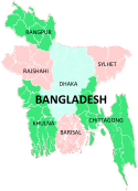
Chittagong Division Bandarban · Brahmanbaria · Chandpur · Chittagong · Comilla · Cox's Bazar · Feni · Khagrachari · Lakshmipur · Noakhali · RangamatiDhaka Division Dhaka · Faridpur · Gazipur · Gopalganj · Jamalpur · Kishoreganj · Madaripur · Manikgonj · Munshiganj · Mymensingh · Narayanganj · Narsingdi · Netrokona · Rajbari · Shariatpur · Sherpur · TangailKhulna Division Rajshahi Division Rangpur Division Sylhet Division Categories:


Wikimedia Foundation. 2010.