- Magura District
-
Magura
মাগুরা— District — Location of Magura in Bangladesh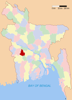
Coordinates: 23°24′N 89°24′E / 23.40°N 89.40°ECoordinates: 23°24′N 89°24′E / 23.40°N 89.40°E Country  Bangladesh
Division Khulna Division Area - Total 1,048.0 km2 (404.6 sq mi) Population (1991) - Total 811,160 - Density 774/km2 (2,004.7/sq mi) Literacy rate - Total 28.5% Time zone BST (UTC+6) - Summer (DST) BDST (UTC+7) Website Banglapedia Article Magura (Bengali: মাগুরা জেলা) is a district in South-Western Bangladesh. It is a part of the Khulna Division.
Contents
Geography
Magura District (Khulna Division) with an area of 1048 km2, is bounded by Rajbari district on the north, Jessore and Narail districts on the south, Faridpur district on the east and Jhenaidaha district on the west. Annual average temperature: maximum 37.1 °C, minimum 11.2 °C; annual rainfall 1467 mm. Main rivers are Gorai, Madhumati, Kumar, Nabaganga and Fatki; Ramsagar and Bural Baor are notable.
Administration
Magura sub-division was established in 1945 and was turned into a district in 1984. The district consists of 4 upazilas, 1 municipality, 18 wards, 61 mahallas, 36 union parishads, 537 mouzas, and 700 villages
Subdivisions
Magura district has 4 sub-divisions / upazilas. They are:
Archaeological heritage and relics: Ghat of Nader Chand, tomb of Pir Mokerram Ali, tomb of Garib Shah, remnants of the Rajbari of Raja Sitaram Roy, Rajbari of Raja Satrujit Roy, fortification of Debal Raja, remnants of the Rajbari of Birat Raja at Sreepur, Mosque at village Gopal (Mughal period), Siddheshwari Math at Athara Khada and Ashram of Nangta Baba (Satdoha Ashram).
Historical events: Indigo uprising of 1859-60, the remnants of Neelkuthi at Hajrapur, Boroi, Amtail Nahati are marks of extensive indigo cultivation. During the War of Liberation the people of Magura encountered the Pak army in about 16 fronts. In these encounters many freedom fighters were killed. The heroic role of Lutfunnahar Helena and her death in the hands of the Razakars are proudly remembered by people.
Marks of War of Liberation Mass grave: Magura PTI compound, WAPDA canal, Binodpur Bazar, Galakata Bridge (Chhaigharia); memorial monument- PTI main gate adjacent to the Magura Bishwa Road.
Others
Religious institutions Mosque 965, temple 341, church 3, tombs and shrines 7.
Literacy & educational institutions Average literacy 28.5%; male 35.2% and female 20.9%. Educational institutions: college 15, primary teacher's training institute 1, technical institute 1, nursing institute 1, high school 94, junior high school 16, madrasa 74, government primary school 266, non-government primary school 101, satellite school 19, kindergarten 10, community school 129.
Cultural organisations Club 173, public library 3, cinema hall 5, theatre group 5, opera party 2, literary society 2, shilpakala academy 1, women's organisation 3.
Locally published newspapers and periodicals Daily: Khedmat; weeklies: Angikar, Grameen Bangla; extinct: Hindu Mussalman Sammilani Patrika (1876), Weekly Ananda (1929), Nabaganga (1941), Weekly Banglar Dak (1972), Weekly Rupashi Bangla (1972), Weekly Magura Barta (1985), Weekly Ganasangbad and Fortnightly Nabakal (1972).
Main occupations Agriculture 51.26%, fishing 1.22%, agricultural labourer 19%, wage labourer 2.53%, industry 1.24%, commerce 9.37%, service 6.01%, transport 2.45% and others 6.92%.
Land use Total cultivable land 78633.66 hectares; single crop 35.60%, double crop 15.29% and treble crop 49.11%; land under irrigation 56.46%.
Land control Among the peasants, 15% are landless, 20% small, 40% intermediate and 25% rich; land per head 0.14 hectare.
Value of land The market value of the land of the first grade is Tk 15000 per 0.01 hectare.
Main crops Paddy, jute, wheat, oil seed, cotton, sugarcane, chilli, onion, turmeric, and varieties of dal (pulse).
Extinct or nearly extinct crops Indigo, barley, china and corn.
Main fruits Mango, jackfruit, black berry, papaya, bel (wood apple), coconut, palm, date and litchi.
Fisheries, dairies, poultries Poultry 241, dairy 80, fishery 981 and hatchery 4, nursery 61.
Communication facilities Roads: pucca 250 km, semi pucca 100 km and mud road 3850; waterways 22-nautical-mile (41 km).
Traditional transport Palanquin (extinct), horse carriage (nearly extinct) and boat.
Manufactories Textile mill, ball pen industry, plastic pipe factory, soap factory, ice factory,Tripty chanachur factory, rice mill, bidi factory, lathe factory and welding.
Cottage industries Weaving, bamboo and cane work, blacksmith, goldsmith, potteries, wood work and tailoring.
Hats, bazars and fairs Total number of hats and bazars is 105, fairs 14.
Main exports Jute, chilli, onion, betel leaf, vegetables and bamboo and cane products.
'Famous Personalities:' Late Mohammad Sohrab Hossain, Ex Member of National Assembly of Pakistan, Bangobondhu cabinet Miniter (1972-5) and the Leader of Liberation War 1971 of Jessore District and the President of first public meeting on the liberated soil of Bangladesh at Jessore, Late Poet Kazi Kader Newaz, Cricket Allrounder Shakib Al Hasan, Late Dariapur Pir Saheb, Late Poet Syed Ali Ahsan, Late Poet Farrukh Ahmad, Late Poet Lutfur Rahman, Greatest Muktibahini Leader Akbar Hossain Miah of "Akbar Bahini", Shahid Sirajuddin Hossain (an intellectual journalist killed by Rajakars during the war of Liberation), Birprotik Golam Eyakub Molla, Late M.Khalilur Rahman (Ex Chief Engineer, Ministry of Works), Abu Saleh (ekushey padak and bangla Academy Padak winner journalist and rhymer), Dr. Shirajul Akbar M.P. (Chairman, Bangladesh Red Crescent Society), Maj.Gen(Retd) Majidul Haque (Ex Minister Govt. of the People's Republic of Bangladesh), Dr. S. M. Asraful Momin-Founder "SHIFA-E-ASRAFIA" (Organization of free treatment for poor), Advocate Sree Biren Sikder M.P., Kazi Salimul Hoq (Ex M.P., Ex Chairman, Prime Bank Ltd and UDI-OMAN),Engr. Md. Nuruzzaman (Chief Enginner,DPHE), Poet & Writer Biren Mukherjee.
 Divisions and districts of Bangladesh
Barisal Division 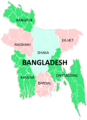
Chittagong Division Bandarban · Brahmanbaria · Chandpur · Chittagong · Comilla · Cox's Bazar · Feni · Khagrachari · Lakshmipur · Noakhali · RangamatiDhaka Division Dhaka · Faridpur · Gazipur · Gopalganj · Jamalpur · Kishoreganj · Madaripur · Manikgonj · Munshiganj · Mymensingh · Narayanganj · Narsingdi · Netrokona · Rajbari · Shariatpur · Sherpur · TangailKhulna Division Rajshahi Division Rangpur Division Sylhet Division Categories:


Wikimedia Foundation. 2010.