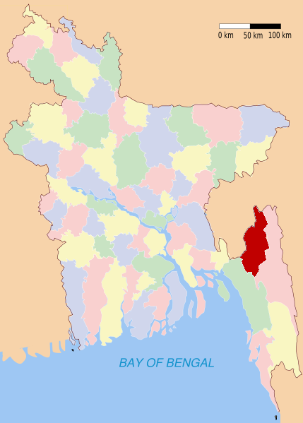
- Khagrachari District
-
Khagrachari
খাগড়াছড়ি— District — Location of Khagrachari in Bangladesh
Coordinates: 23°02′30″N 91°59′40″E / 23.0417°N 91.9944°ECoordinates: 23°02′30″N 91°59′40″E / 23.0417°N 91.9944°E Country  Bangladesh
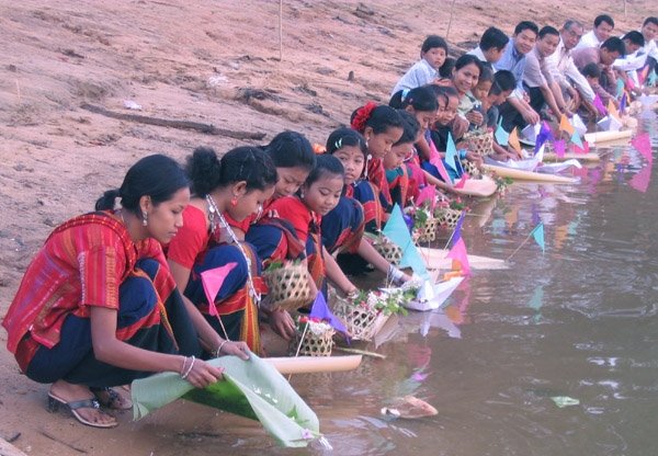
Division Chittagong Division Area – Total 2,699.55 km2 (1,042.3 sq mi) Population (1991) – Total 524,961 – Density 194.5/km2 (503.7/sq mi) Literacy rate – Total 26.3% Time zone BST (UTC+6) – Summer (DST) BDST (UTC+7) Website Banglapedia Article 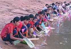 Tribal women near Ful Biju Chengi River, Khagrachhori. Photo:Biplob Rahman
Khagrachari (Bengali: খাগড়াছড়ি) is a district in south-eastern Bangladesh. It is a part of the Chittagong Division and the Chittagong Hill Tracts. Its local name is "Chengmi". Khagrachari is also known as Phalang Htaung (ဖလံေထာင္) or the Mong Circle (of the rest of the three hill districts Rangamati is the Chakma Circle (သက္ေထာင္) and Bandarban (ဗိုလ္မင္းေထာင္) is the Bohmong Circle).
Khagrachari town is the home town of the Mong Chief (currently King, or Raja, Saching Prue Chowdhury ဗိုလ္မင္း သာစိန္ျဖဴ) who is the head of the Arakanese descendants living in the circle. It also is the administrative headquarter of Khagrachari district.
Contents
Geography
Khagrachari is a valley. It has three river namely Chengi, Kasalong and Maini. Chengi is the longest river in Khagrachari. Most of the land of Khagrachari are hilly areas.
Subdivisions
Upazilas under this district are:
- Dighinala Upazila
- Khagrachhari Upazila
- Lakshmichhari Upazila
- Mahalchhari Upazila
- Manikchhari Upazila
- Matiranga Upazila
- Panchhari Upazila
- Ramgarh Upazila
Economy
Most of the people lives on Jhum cultivation.
Places of interest
Khagrachari’s attractive tourists’ spots
1. Alutila Tourists spot: Khagrachari – Chittagong Road, 5 Km away from the Parjatan motel. Local Buses or Chader gari, fare- 8/10 tk. Microbus can be rented as well.
2. Alutila Mysterious Cave: East of the Alutila Tourists’ spot under the mountain 150 meter long flowing natural waterfall. Chittagong Road, 5 Km shout from the motel. Local Buses or Chader gari, fare- 8/10 tk. Microbus can be rented as well.
3. Richhang waterfall: Khagrachari – Chittagong road the area of Hridoy member. 7 km shout from the Porjoton motel. 2 km shout from Alutila, 1.50 km from east from the main road. Local bus or Chader gari till Hridoy Member area. Rest 1.50 km by foot.
4. Hundred or more years old banyan tree: Hundred or more years old banyan tree which is spreading almost 2 acres. Till Matiranga 10 number region of Khagrachari- Chittagong Road Buses / chader gari. Fare 10/15 tk, and rest 1.5 km by foot or own vehicles.5. Nunchhori Debota Pond: The Nunchhori Tripura Village is 13 km south from Porjoton motel, 4 km west from Maishkhali Army camp of Khagrachari – Rangamati road. From there almost 1500 feet above, at the peak of the Mountain is the Debota lake. Local bus or chader gari of Khagrachari – Rangamati Route till Maishchori Army camp. Rest of the 4-5 km by foot. If there is private car then it can go till the Tripura Village.
6. Yonged Buddha Bihar: At Khagrachari town, 2 km far from Motel. Accessible by rickshaw.
7. Panichari Brihot Buddha sculpture: Shantipur Arannya Kuthir - 25 km south from Khagrachari is peripheral region. The largest Buddha sculpture of Bangladesh is situated here. Khagrachari – Panichari Local bus fare- 35 tk. The road is flat.
8. Dighinala Manikker Dighi: One regional town situated 21 km south from Khagrachari. The Jhulonto Bridge, Buddha Bihar, Raja Manikker Dighi, Tribal culture, tradition and ancient standard of living. Khagrachari – Dighinala Bus/ 4 Wheel drive gyp.
9. Dighinala Touduchhori Waterfall: It contains wild Elephants roaming around in groups; the place is cluttered with enormous stones and waterfalls. From Khagrachari – Dighinala road Bus/ Chader gari (gyp), fares 25/40 tk. Rest of the road by foot. The communication here is not urbanized yet.
10. Shajek and Marissa Vally: Endless natural beauty of green Mound. It’s hard to describe in words. It’s better if a private or rented car is available.
Religious composition (1991)
Muslim - 53.45%, Buddhist - 48.51%, Hindu - 16.69%, Christian - 0.27% and Others - 0.08. Religious institutions 2472 mosques, 937 Buddhist (656 pagodas, 281 temples), 170 temples and 4 churches. [1]
See also
References
Template:Fariaz Morshed Chowdhury
 Divisions and districts of Bangladesh
Barisal Division 
Chittagong Division Bandarban · Brahmanbaria · Chandpur · Chittagong · Comilla · Cox's Bazar · Feni · Khagrachari · Lakshmipur · Noakhali · RangamatiDhaka Division Dhaka · Faridpur · Gazipur · Gopalganj · Jamalpur · Kishoreganj · Madaripur · Manikgonj · Munshiganj · Mymensingh · Narayanganj · Narsingdi · Netrokona · Rajbari · Shariatpur · Sherpur · TangailKhulna Division Rajshahi Division Rangpur Division Sylhet Division Categories:- Khagrachari District
- Districts of Bangladesh
- Bangladesh geography stubs

Wikimedia Foundation. 2010.