- Narail District
-
Narail
নড়াইল— District — Location of Narail in Bangladesh
Coordinates: 23°08′N 89°30′E / 23.13°N 89.50°ECoordinates: 23°08′N 89°30′E / 23.13°N 89.50°E Country  Bangladesh
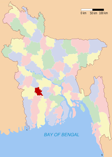
Division Khulna Division Area – Total 990.23 km2 (382.3 sq mi) Population (1991) – Total 689,021 – Density 695.8/km2 (1,802.2/sq mi) Literacy rate – Total 35.65% Time zone BST (UTC+6) – Summer (DST) BDST (UTC+7) Website Banglapedia Article Narail (নড়াইল) is a district in South-western in Bangladesh. It is a part of the Khulna Division.
Contents
Geography
Narail District (নড়াইল) (Khulna Division) with an area of 990.23 km², is bounded by Magura District on the north, Khulna District on the south, Faridpur District and Gopalganj District on the east, and by Jessore District on the west. Annual average temperature is maximum 37.1C, minimum 11.2C; annual rainfall is 1467 mm. Main rivers are Madhumati (মধুমতি), Nabaganga (নবগঙ্গা), Bhairab (ভৈরব), Chitra (চিত্রা) and Kajla (কাজলা). There are many beels (বিল) and baors (বাওড়) most noted of which is Chachuri Beel.
Total Land Area 240,439-acre (973 km2) , Cultivable Area 176,504-acre (714 km2), Fallow Land 25,090-acre (102 km2), Area Under Forest 10 Acre, Area Irrigated 36,208-acre (147 km2), Area Under River 8,562-acre (35 km2)
Upazillas
Narail Sadar (নড়াইল সদর), Lohagara (লোহাগড়া), Kalia (কালিয়া) The District of Narail or Narail Zilla in the Bengali has three upzillas: Narail, Kalia and Lohagara. Narail Upzilla or Narail Sadar is the administrative and business center of Narail district where the offices of the Deputy Commissioner, Superintendent Police, Additional District Magistrate and other local government officials are located.
History
Narail's headquarter was named so because of the Zamindars of Narail. The Zaminders established the shopping market called Rupganj - named after a Zaminder. They also established a post office there for the first time during British Raj - called Ratanganj - again named after another Zaminder. They modernised Narail by the standard of those days. They also promoted culture, sports and education in that part of the world. The large playing field called "Kuriddobe" was their gift. They introduced football competition in that part with a shield given to the champions and a cup the runners-up as well as medals to all players from early twentieth century. One of the Zamiders moved away from Narail and settled in Hatbaria where they established another large building (Zamider Bari) or rather buildings joined together.
Administration of Narail district was established in 1984. It consists of two municipalities, 18 wards, 43 mahallas, 3 upazilas, 4 police Thana (Narail, Kalia, Lohagara and Naragathi), 37 union parishads, 445 mouzas and 649 villages. The upazilas are Narail Sadar, Kalia, Lohagara and (newly formed) Naragati. Municipalities are Narail Sadar and Kalia.
Religion
The district of Narail consists 1675 mosques, 248 temples, four churches, seven tombs and 11 shrines.
Places of interest
Archaeological heritage and relics: Mosque at Village Goalbathan (1654), Kadamtala Mosque, Ghazir Dargah at Naldi, homestead of Raja Keshab Roy at Wazirpur, Radha Govinda Mandir at Jorbangla (eighteenth century), Kalibari at Lakshmipasha, Math at Baradia of Nishinathtala.Dr. Niharanzon gupta ar barri,Itna,Lohagara. Narail Victoria College and Collegiate School is one of the oldest modern high school in Bangladesh - established in 1858 by the zaminders of Narail who were famous for their love of education. Same Zaminders also established a girls' school which was a rarity in Bangladesh at that time. It's called Shib Shankar Memorial Girls' School. This school closed down due to lack of finance after the Zaminders left then East Pakistan. It was re-opened by some local enthusiasts Mr. J Bhattacharjee, Mr. S Biswas & Mr B Bhowmic. They borrowed furnitures from neighbours including my parents. They also went round to houses pleaing to send their children to the school. I along with two of sisters went to the school as they allowed boys at that time. Narail's Zaminder bari was one of the biggest in whole of Bengal. But unfortunately when the Zaminders left the country after partition of India, the whole house was looted and vandalised. It gradually collapsed. There is still some remains present specially the Kalibary, the Shib mandir and the Bandha ghat on the Chitra river. Some local people continued the famous Durga Puja in the capmpus of the Zamider Bari, but it stopped after a few years for obvious reason. Part of the building was used for some time as Government civil service office. But due to lack of maintenance it gave in. The famous writer - Bankim Chandra Chattopadhyay was a magistrate in Narail and his book Neelkuthi was based on the forceful cultivation of Indigo in Narail by the East India Company. Narail was once declared "Independent" from the British Raj by "Sharala-di" as she was known at the time by her followers of independence movement of India. But for obvious reason the "independence" only lasted for 3 days.
Educational Institutions
- Narail Victoria College
- Narail Zila high School
- Lohagara Pilot High School
- Lohagara Adarsha Mohavidyalay
- Parbati Bidhyapith,Gobra
- Gobra Mittra Mahabiddyalya
Famous Personalities
Poet & Creative Personalities:
- Bijoy Sarkar
- Mashrafe Bin Mortoza
- Dolar Mahmud
- S M Sultan
See also
References
 Divisions and districts of Bangladesh
Barisal Division 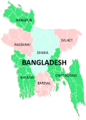
Chittagong Division Bandarban · Brahmanbaria · Chandpur · Chittagong · Comilla · Cox's Bazar · Feni · Khagrachari · Lakshmipur · Noakhali · RangamatiDhaka Division Dhaka · Faridpur · Gazipur · Gopalganj · Jamalpur · Kishoreganj · Madaripur · Manikgonj · Munshiganj · Mymensingh · Narayanganj · Narsingdi · Netrokona · Rajbari · Shariatpur · Sherpur · TangailKhulna Division Rajshahi Division Rangpur Division Sylhet Division Bold text
Categories:

Wikimedia Foundation. 2010.