- Naogaon District
-
Naogaon
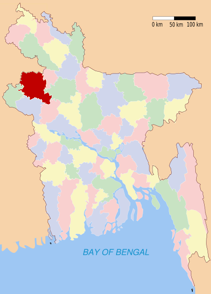
নওগাঁ— District — Location of Naogaon in Bangladesh
Coordinates: 24°54′N 88°45′E / 24.90°N 88.75°ECoordinates: 24°54′N 88°45′E / 24.90°N 88.75°E Country  Bangladesh
Division Rajshahi Division Area - Total 3,435.67 km2 (1,326.5 sq mi) Population (1991) - Total 2,377,314 - Density 692/km2 (1,792.1/sq mi) Literacy rate - Total 28.4% Time zone BST (UTC+6) - Summer (DST) BDST (UTC+7) Website Banglapedia Article Naogaon (Bengali: নওগাঁ Nôogã) is a district in Northern Bangladesh. It is a part of the Rajshahi Division.
Contents
Upazilas
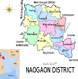
The district is divided into the following upazilas:
- Naogaon Sadar Upazila
- Manda Upazila
- Niamatpur Upazila
- Atrai Upazila
- Raninagar Upazila
- Patnitala Upazila
- Mahadevpur Upazila
- Dhamoirhat Upazila
- Sapahar Upazila
- Porsha Upazila
- Badalgachhi Upazila
Municipalities
There are three Municipalities in this district.
- Naogaon Municipality
- Nazipur Municipality
- Dhamoirhat Municipality
- Mohadevpur
History
Paharpur
Paharpur is a small village 5 km west of Jamalganj in the greater Rajshahi district where the remains of the most important and the largest known monastery south of the Himalayas[citation needed] have been excavated. This 7th century archaeological find covers approximately an area of 27 acres (110,000 m2) of land. The entire establishment, occupying a quadrangular court, measures more than 900 ft (270 m), and is from 12 to 15 ft (3.7 to 4.6 m) in height. With an elaborate gateway complex on the north, there are 45 cells on the north and 44 in each of the other three sides, for a total number of 177 rooms. The architecture of the pyramidal cruciform temple is profoundly influenced by those of South-East Asia, especially Myanmar and Java. It takes its name from a high mound, which looked like a pahar, or hillock.
A site museum built recently houses the representative collection of objects recovered from the area. The excavated findings have also been preserved at the Varendra Research Museum at Rajshahi. The antiquities of the museum include terracotta plaques, images of different gods and goddess', pottery, coin inscriptions, ornamental bricks and other minor clay objects.
Nine miles west-southwest of Paharpur is the archaeological site of Halud Vihara, which has been tentatively listed as a Unesco World Heritage Site.[citation needed]
Kusumba Mosque
Kusumba Mosque is named after the village of Kusumba, under the Manda upazila of Naogaon district, on the west bank of the Atrai river. It lies inside a walled enclosure with a monumental gateway with standing spaces for guards. It was built by a high ranking official named Sulaiman, during the period of Afghan rule in Bengal, under one of the last Suri rulers, Ghiyasuddin Bahadur Shah. The inscription tablet is in Arabic, with only the word 'built by' in Persian, dates the building to 966 AH (1558-59 AD), and is fixed over its eastern central entrance. Although built during Suri rule, the mosque is not influenced by the earlier Suri architecture of North India, and is well grounded in the Bengal style. The brick building, gently curved cornice, and the engaged octagonal corner towers are typical features.
The mosque, presently protected by the Department of Archaeology of Bangladesh, was badly damaged during the earthquake of 1897. Although the main fabric of the building is of brick, all of the exterior walls, and the interior up to the arches of the pendentives, have stone facing. The columns, platform, floor, and perforated side screens are of stone. The mosque has a rectangular plan with three bays and two aisles, three entrances on the east, and two each on the north and south sides.
The central mihrab is projected in the west. The interior west (qibla) wall has two mihrabs on the floor level opposite the central and southeastern entrances, but the one in the northwestern bay is above a raised platform ascended by a staircase on the east. The presence of such a platform in a non-imperial mosque indicates that not only royalty, but nobility and high-ranking officials were also separated from the general public during prayers.
The mihrabs have elaborate stone carving. They have cusped arches crowned with kalasa (water pot) motifs, supported on intricately carved stone pillars which have projections and tasselled decorations hanging from chains. Bunches of grapes and vines curve in an almost serpentine manner on the mihrab frames, and kalasas, tendrils, and rosettes are reduced to dots. The platform edge has grape vine decoration, and there are rosettes on the spandrels of the arches supporting the platform, as well as on the mihrab wall.
The stone used in the exterior facing is of coarse quality and is carved in shallow relief. Mouldings are the most prominent decorative feature on the outside. They divide the walls into upper and lower sections, run all along the curved cornice, around the corner towers, and frame the rectangular panels in the east, south, and north walls. The spandrels of the central entrance arch are filled with small kalasa and rosette motifs. The north and south sides have screened windows.[1]
Patisar
Patisar village is associated with Rabindranath Tagore. It is situated on the banks of the Nagor, 12 kilometres south-east of the Atrai railway station and 26 kilometres from the district town. The headquarters of the Tagore family's zamindari in Kaligram Pargana was located at Patisar. Dwarkanath Tagore, the grandfather of Rabindranath Tagore, purchased this zamindari in 1830. Rabindranath Tagore first came to Patisar in January 1891.
The architectural design of the two-storied Kuthibari of Patisar is similar to that of Shilaidaha-Shahjadpur. The buildings, adjacent to the main mansion, are now reduced to ruins. A pond, named Rabindrasarobar, is now a silted up marsh. During his stay at Patisar, Tagore composed various poems, stories, novels, essays and the verse-play Biday Abhishap. He also established many primary schools, a school named Rathindranath High School, charitable dispensaries, and Patisar Krishi Bank (1905). He introduced tractors in Patisar and formed co-operative societies for the development of agriculture, handloom, and pottery.
In 1921, when the zamindari was divided, Patisar was included in Tagore's share. When the poet was awarded the Nobel Prize, the tenants of Patisar gave him an address of honour (1913). On the request of his tenants, Tagore visited Patisar in 1937 for the last time on the occasion of Punya. Every year many devotees of Tagore come from home and abroad to visit Patisar. On the occasions of Tagore's birth and death anniversaries, discussion meetings and cultural functions are held at Patisar.
Dubalhati
Dubalhati is an ancient site in the south-western part of the district. The road to Dubalhati passes through the wide bill named “Digholi bill”. There is a large well in the center of the road for providing travellers with water. Today the road is becoming a recreational place for the town dwellers because of its natural beauty.[citation needed]
The most notable feature of Dubalhati is “Lord House (Jomidar Bari/Rajbari)". The house has two parts; the main part, Darbar Hall, is residential and also used for holding seminars, while the other part, Natto Shalla, is for prayers. The rajbari is a three-story building standing on wide and long masonry slender spiral columns. There are also four big dhighi around the site.
The rajbari was first built by Raja Horandro Ray Chodhory during the Pala Dynasty (781–1124). About 53 rajas have ruled the region, beginning with Jogotram, and ending with Haranath Ray Bahadur II in 1971. The rule of Raja Horonath Ray Bahadur I was notable for his construction of schools in Rajshahi and Naogaon district, including as Natto Shala, Baganbari, Dubalhati High school, Naogaon K.D. School, and the Rajshahi Government College. He founded Dubalhati Raja Horonuth High School, only the second high school in the Rajshahi Division, in 1864. He also built many wells and dhighi for providing drinking and irrigation water, and provided food during the famine of 1874.
Economy
Today Naogaon District is considered the bread basket of Bangladesh. It is the central part of Borendra Region, with an area of about 3,435.67 square kilometres (1,326.52 sq mi), about 80% of which is under cultivation. The soil of the area is a fertile inorganic clay called dhoyass.
The total population of the area is about 25 lac, and most of the people of the district are farmers. The literacy rate is 44.39%. Crops grown in the district include paddy, jute, wheat, maize, sugar cane, potatoes, pulses, oil seeds, brinjal, onions, and garlic. The total production of paddy and what in 2009-2010 was 13,58,432 metric tons, including a surplus of 8,26,835 metric tons. Today it is the top listed district in the side of rice production and has the highest number of rice processing mills of any district.[2]
Religion
The district of Naogaon consists 3864 mosques, 1018 temples, 96 churches and 51 Buddhist churches. Kusumba mosque is the famous mosque in this district.
Famous places of Naogaon
- Shampur Bihar, PaharPur, Badalgacchi
- Dubalhati Rajbari
- Kusumba Masjid, Manda
- Patishar (Rabindranath Tagor's KuthiBari)
- AltaDighi Dhamoirhat
- Mohadevpur Razbari
- Dibor Dighi-Patnitola
- Gahon pirbabar Mazar-Patnitola
- Kancon-Hazarat Zahor Uddin Cistia Babar Mazar-Patnitola
- Katabari Mazar Patnitola
- Dudulhati ROyal Palace, Sadar
- Balihar Royal Palace, Sadar
- Vimer Panti, Dhamuirhat
- Jogoddol Bihara, Dhamoirhat
- Mahisontos, Dhamoirhat
- Halud Bihar
Hats and bazaars
- Dubalati Bazar
- Satihat
- Chaubaria Hat
- Chawkgaurihat
- Matajihat
- Mohadebpurhat
- Dhamoir Hat
- Kholishakuri Hat
- Lakhaijani Hat
- Hapania Hat
- Entetala Hat
- Kritipurhat
- Abadpukur Hat
- Nazipur Natunhat
- Nazipur Puraton Bazar Hat
- Bandaikhara Bazar
- Katkhoir Hat
- Ahashangonj Hat
- Bedhgari Hat
- Vobanipur Hat
Fairs
- Dubalhati Poush Parbon Mela
- Kalitala Rath Mela
- HinduBaga Mela
- Gudishahar Mela
- Shibpur Lakshmi Mela
- Kashipur Mela
Educational institutes
- Al-Helal Islami Academy School, Sapahar.
- Dubalhati Govt. Primary School, dubalhati, Naogaon
- Dubalhati Hafezia and Forkanea Madrasha, Dubalhati, Naogaon
- Chalkenayet Model Government Primary School
- Naogaon Government Girls High School, Naogaon
- Naogaon Government College, Naogaon.
- Naogaon B. M.C. Government Mohila College, Naogaon
- Naogaon Polytechnic Institute, Dubalhati Road, Naogaon
- Momen Shana College, Manda, Naogaon
- Naogaon K.D. Government High School
- Naogaon Zilla School
- Tilakpur Government Primary School, Tilakpur, Naogaon
- Tilakpur Moslim High School, Tilakpur, Naogaon
- Naogaon Janakallan Model High School
- Gobindapur High School
- Bangal Para Government Primary School
- Hapania High School
- Ratowal Bishwo Kabi Rabindranath Tagore Dimukhi High School
- Paharpur G. M. High School, Established in 1936
- Paharpur Government Primary School
- Jahangirpur Model High School, Mohadavpur
- Saraswatipur High School
- Rasulpur High School
- Kushadanga High School
- Pirojpur High School
- Bilkorilla B.M. High School
- Katkhoir High School
- Pakuria High School
- P.M Girls High School
- Shaluka High School
- Kirtipur High School
- M.P, J.N.V. School, a polytechnic college
- Primary Teacher's Training Institute
- Bandaikhara High School
- Katkhoir High School
- Al-Helal Islami Academy School, Sapahar
- Sapahar Pilot High School
- Sapahar KG School
- Sapahar Govt. Degree College
- Sapahar Govt. Model Primary School
- Sapahar Govt. Girls School
- Teghoria High School, Sapahar
- Sahagola High School, Sahagola,Atrai.
- Potishor Rothindra Nath Institute,Potishor, Atrai.
Newspapers and weekly periodicals
- Nabajug
- Nabadiganta
- Saptahik Bangabani
- Bakachand
- Nababarta
- Banglar Kantha
- Little Magazine
- Sangkalon
- Tolpar
- Protichhabi
- Kalbela
- Eisomoy
- Calantika
- Anjali Loho Mor
Got Gari Shahid Mamun High Scool & College Raigaon High School Raigaon College
See also
References
3. Mizanur Rahman Sohag, Dhaka Residential Model College, Sapahar, Naogaon.
External links
 Divisions and districts of Bangladesh
Barisal Division 
Chittagong Division Bandarban · Brahmanbaria · Chandpur · Chittagong · Comilla · Cox's Bazar · Feni · Khagrachari · Lakshmipur · Noakhali · RangamatiDhaka Division Dhaka · Faridpur · Gazipur · Gopalganj · Jamalpur · Kishoreganj · Madaripur · Manikgonj · Munshiganj · Mymensingh · Narayanganj · Narsingdi · Netrokona · Rajbari · Shariatpur · Sherpur · TangailKhulna Division Rajshahi Division Rangpur Division Sylhet Division [Kamruzzaman, Dubalhati, Naogaon]
- sohag_sapahar@yahoo.com 01555049205
Categories:


Wikimedia Foundation. 2010.