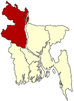
- Manda Upazila
-
Manda
মান্দা— Upazila — Location in Bangladesh Coordinates: 24°46.5′N 88°40.2′E / 24.775°N 88.67°ECoordinates: 24°46.5′N 88°40.2′E / 24.775°N 88.67°E Country  Bangladesh
Division Rajshahi Division District Naogaon District Area – Total 375.94 km2 (145.2 sq mi) Population (1991) – Total 330,995 – Density 880/km2 (2,279.2/sq mi) Time zone BST (UTC+6) Website Official Map of Manda Manda (Bengali: মান্দা) is an Upazila of Naogaon District in the Division of Rajshahi, Bangladesh.
Contents
Geography
Manda is located at 24°46′30″N 88°40′10″E / 24.7750°N 88.6694°E. It has 58493 units of house hold and total area 375.94 km².
Demographics
As of the 1991 Bangladesh census, Manda has a population of 330995. Males constitute are 50.56% of the population, and females 49.44%. This Upazila's eighteen up population is 157744. Manda has an average literacy rate of 24.3% (7+ years), and the national average of 32.4% literate.[1] [Sarwar Toha]
Administrative
Manda has 14 Unions/Wards, 299 Mauzas/Mahallas, and 286 villages.
Unions are:
- Bharso
- Bhalain
- Paranpur
- Manda
- Ganeshpur
- Mainam
- Prasadpur
- Kushumba
- Nurullabad
- Kalikapur
- Tetulia
- Kanshopara
- Kashab
- Bishnopur
[Sarwar Toha]Liberation Mass
Marks of the War of Liberation Mass grave 1 (Manoharpur), mass killing site 1 (Pakuria). [Sarwar Toha]
Historical events
- Historical events During the War of Liberation in 1971 the Pak army brutally killed 128 innocent persons at village Pakuria of Bharsho Union and buried them in 3-4 ditches[Sarwar Toha]
- Historical events During the War of Liberation in 1971 the Pak army brutally killed 17 innocent persons & burned a hole village monhorpur of Paranpur Union and buried them in 3-4 ditches[Nurul Kukrail]
School Colleges
- Manda College
- Gobindapur High School
- Bangal Para Govt Pri. School.
- Daspara Degree College.
- Chakuli high school
- Chakuli degree college
- Chakuli koumi madrasha
- Chakuli priamary school
- Got Gari Shaheed Mamun High school & College
- Balubazar S M High school
- Shafiuddin mollha college
- Satihat K.T. High School
- Prashadpur Girls High school
- Manda Pilot High school
- Shahapur D.A. High School
- Par Enayetpur Govt Primary School
- Bilkorilla B.M.High School.
- Pakuria High School.
- Nurullabad M/L High School.
- Jotbazer Gril School& Collage
- Nurullabad Primary School.
- Daspara High School.
- Nurullabad Nikhirapara Govt. Primary School.
- Chakuli bahumokhi madhumik biddaloy
- Shreerampur (1)Govt Primary School
- Shreerampur (2) Govt Primary School(Satihat)
- Gobindapur Govt Primary School
- Chakkamdeb technical and BM college
- Jafrabad Adorsho Dakhil Madrasha
- Alalpur haji sheikh alam high school.
- Kukrail abtadai madrasha
- Banishar dakhil madrasha
- Chalkharinarayan Dhakhil Madrsha.
- Kaligram Dodangi High School*
- Rangamatia Reg. Primary School
Main crops
Paddy,wheat,Jute, mustered, potato, sugarcane, bringal, patal, kachu, banana, onion, garlic, turmeric, sesame, kalai [Sarwar Toha]
Main fruits
Mango, Kul, litchi, jackfruit, papaya, guava, Banana [Sarwar Toha]
See also
References
- ^ "Population Census Wing, BBS.". Archived from the original on 2005-03-27. http://web.archive.org/web/20050327072826/http://www.bangladeshgov.org/mop/ndb/arpc91_v1/tables04.htm. Retrieved November 10, 2006.
 Upazilas of the Rajshahi DivisionCapital: Rajshahi
Bogra District Adamdighi · Bogra · Dhunat · Dupchanchia · Gabtali · Kahaloo · Nandigram · Sariakandi · Sahajanpur · Sherpur · Shibganj · Sonatala
Joypurhat District Naogaon District Atrai · Badalgachhi · Dhamoirhat · Manda · Mahadevpur · Naogaon · Niamatpur · Patnitala · Porsha · Raninagar · SapapharNatore District Nawabganj District Pabna District Rajshahi District Sirajganj District Thakurgaon District Categories:- Upazilas of Naogaon District
- Rajshahi Division geography stubs
Wikimedia Foundation. 2010.

