- Nawabganj District
-
Chapai Nawabganj
চাঁপাই নওয়াবগঞ্জ— District — Coordinates: 24°44′N 88°12′E / 24.73°N 88.20°ECoordinates: 24°44′N 88°12′E / 24.73°N 88.20°E Country  Bangladesh
Division Rajshahi Division Area - Total 1,744.33 km2 (673.5 sq mi) Population (1991) - Total 1,419,534 - Density 813.8/km2 (2,107.7/sq mi) Literacy rate - Total 23.8% Time zone BST (UTC+6) - Summer (DST) BDST (UTC+7) Postal code 6300 Website Banglapedia Articlewww.chapainawabganj.com Chapai Nawabganj (চাঁপাই নওয়াবগঞ্জ)[1] is a district in Northern Bangladesh. It is a part of the Rajshahi Division. Originally it was a subdivision under Malda district. In 1947, this was severed from Malda and was given to East Pakistan as a sub-division of Rajshahi district. Eventually,it became a separate district of Bangladesh in 1984.[2]
Contents
Geography
Chapai Nawabganj District (Rajshahi division) with an area of 1744.33 km², is bounded by West Bengal of India on the north, south and west, rajshahi and naogaon districts on the east. The district lies under barind tract and consists of diaras and charlands (sandbars develop in riverbed). The main rivers are the Ganges, Mahananda, Pagla, Moraganga and the
 Geography
[3] Punarbhaba. Beel Bhatia, Beel Choral, Beel Hogla, Beel Singra, Sukrabari Damos, Maricha Dara, Beel Putimari, Beel Anal, Kumiradaha are the noted depressions. Annual average temperature: maximum 37.8 °C, minimum 11.2 °C; annual rainfall 1862 mm.
Nawabganj (Town) consists of 15 wards and 70 mahallas. It has an area of 46.26 km². Nawabganj municipality was established in 1903. The town has a population of 153252; male 48.37% and female 51.63%; population density is 3313 per km². Literacy rate among the town people is 41.2%. The town has two dakbungalows, one circuit house, one officers' club, one BDR Camp, one Mango Research Centre, one sericulture centre and one horticulture centre.
Civic Administrations
The district consists of 3 municipalities, 33 wards, 134 mahallas, 5 upazilas, 45 union parishads, 830 mouzas and 1136 villages. The upazilas are
- Bholahat Upazila, ভোলাহাট উপজেলা
- Gomastapur Upazila, গোমস্তাপুর উপজেলা
- Nachole Upazila, নাচোল উপজেলা
- Nawabganj Sadar Upazila, নবাবগঞ্জ উপজেলা and
- Shibganj Upazila, শিবগঞ্জ উপজেলা
Municipalities are
- Nawabganj Sadar , নবাবগঞ্জ সদর,
- Shibganj , শিবগঞ্জ,and
- Rohanpur, রহনপুর
Transportation
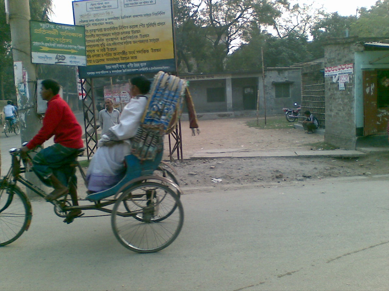
This district is the most western district in Bangladesh which has boundary with the neighboring country India. And for importing and exporting, there is a land port in this district which makes this district an important route for communicating with the neighboring country. And the construction of the Jamuna Bridge at Sirajganj also makes its transportation system an important one all over the country. That is why highways were constructed over the district. The major transport systems inside the town is the bike, rickshaws, bi-cycle and CNG rickshaws.
 Rickshaw-The main intra-transport vehicle
Bus
The major transportation system in this town is the bus service to different districts and towns. The main transportation route is Nawabganj-Rajshahi. The bus transportation service is off three types which are gate-lock, direct and local service. The others bus routes are Nawabganj-Shibganj, Nawabganj-Naogaon, Nawabganj-Nachol, Nawabganj-Rohanpur. The BRTC bus service serves for the long intra-district route to almost all important districts of Bangladesh. The most important long route is the Nawabganj-Dhaka. There are lots of bus services on this route. There are two bus stopages. The biggest one is called Chapai Nawabganj Bus Terminal and the other is the Dhaka Bus Terminal.
Railway
There are limited railway services with Rohanpur and Rajshahi. One of the international rail line passes through the district to Malda, West Bengal, India.
Waterway
In the past, the main transport system was based on the water path. The river Padma (Ganges), Mahananda River, Pagla, Moraganga and some beels (marshland) were used for intra-transport system. The water level went down due to adverse effect of Farakka Barrage on Padma (Ganges) river, and therefore, water transport has lost its popularity. But still rivers are used for transportation of daily goods from different parts of the district. Still the transportation from the villages in western and eastern parts of the district depends on the boat.
History
Administration Until 1947, Nawabganj was a thana under the district of Maldah (India). At the time of partition, it was upgraded to a Subdivision under Rajshahi district and again upgraded to a district in 1984. Great politician and scholar Idris Ahmed Miah M.L.A was born 13th Sep, 1894 at Dadanchak, Shibgonj and died 9th Oct, 1966. He was buried at Adina College Campus. He is called father of Education in North Bengal. Because he founded Adina College in 1938 and it is the fourth oldest college in North Bengal. He founded many educational institution in his period. He was also the first founder member of Rajshahi University.
Historical events.
- Indigo Resistance Movement led by Dewanatullah Chowdhury in 1830-35 and
- Nachole Krishak Andolan (peasants' movement) organised by ila mitra in 1949.
Marks of War of Liberation Mass killing site
- Nawabganj Shmashan (crematorium of Hindus),
- Rehaichar,
- Rohanpur Station Para,
- Satiar Bazaar (Bholahat) and
- Jadunagar (Bholahat);
Mass grave
- near Sona Mosque,
- Shamsanghat,
- Boalia,
- Islampur and Gomostapur Fakirpara;
Memorial monument
- BDR (Bangladesh Rifles) compound, near Sona Mosque and
- premises of Chatrajitpur School and College.
Adina College.
Economy
This district is mainly a plane land with rivers. The whole district is full of fertile land with proper irrigation facilities. That's why the economy is totally dependent on the agriculture. But as there are a number of rivers flows by this district, lots of people depends on the river like fishing and some business related to the rivers.
Main occupations
- Agriculture 34.07%,
- commerce 16.6%,
- service 4.01%,
- agricultural labourer 24.31%,
- wage labourer 5.39%,
- construction 2.57% and
- others 13.05%.
Land Property
Land usage
- Total cultivable land 132354 hectares,
- fallow land 12899 hectares.
- Single crop 46%,
- double crop 45% and
- triple crop land 9%;
- cultivable land under irrigation 60%.
- Mango gardens occupy 6690 hectares.
Land control Among the peasants 35% are landless, 44% marginal, 27% intermediate and 4% rich; cultivable land per head 0.07 hectare.
Value of land The market value of the first grade is Tk. 8500 to 10000 per 0.01 hectare.
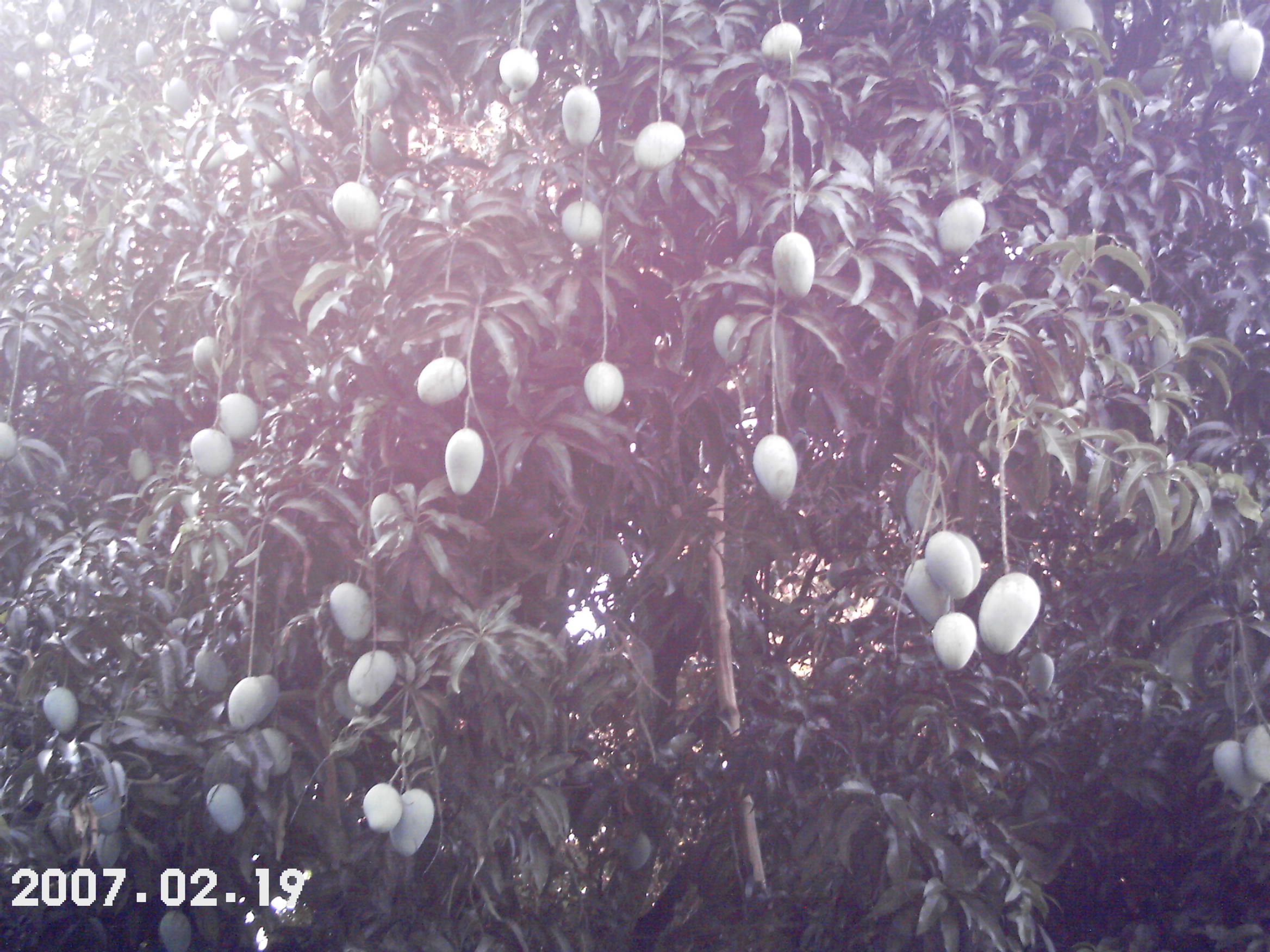
Mangoes
Chapai Nawabganj is called the capital of mango. The main product which mainly accelerates the economy of this district. Lots of mangoes are produced in summer each year. Most of the land of this district is full of mango orchards where various kinds of mango are produced. The economy is surrounded by the production of the mango in this district. The main part of mango production is the Shibganj, Bholahat and Gamostapur upozilla.
Agriculture
Main crops Paddy, jute, sugarcane, wheat, betel leaf, oil seeds, pulses.
Extinct and nearly extinct crops Indigo, koda, maara (one kind of pulse), china (common millet).
Main fruits Mango, jackfruit, litchi, black berry, palm, coconut, watermelon and boroi.
 Mango-The main Economic product
Fisheries, dairies, poultries Fishery 2, dairy 142, poultry 39.
Communication facilities Roads: pucca 286.12 km, semi pucca 2006.81 km; railways 51.20 km; waterways 69-nautical-mile (128 km).
Traditional transport Palanquin, horse carriage. These means of transport are either extinct or nearly extinct.
Manufactories Silk mill, textile mill, cold storage and aluminium factory.
Cottage industries About 6500 cottage industries including silk, weaving, copper, bell-metal and brass works; nakshi kantha; decorated shika (hanging rope-shelf); potteries; hand-fans; bamboo and cane-works, etc.
Hats, bazaars and fairs Hats and bazaars are 140, fair 25.
Main exports Mango, jackfruit, betel leaf, sugarcane, date molasses, silk sari, copper, bell-metal and brass work.
Culture
Gombhira Gaan
Gombhira gaan is one kind of folk song popular in this district and as well as the northeaster part of Bangladesh.It is assumed that gombhira gaan was originated from the worship of the god SHIVA (one of the god of Hindu religion), who was also known as 'Gombhir'. This type of song was used only in Puja (worship) in past time. Most of the Hindu community celebrated the puja of Dharma Thakur (a popular god of Hindus) on the last day of the Bengali year which was known as GAJAN of shiva in medieval era. At that time, it was imagined that SHIVA was present at the performance. Initially, Gombhira was of two kinds; the primary Gombhira in which god and goddess were addressed and human joys and sorrows were described and sometimes important events of the year were described. In secondary Gombhira also called narrative Gombhira, every character would represent a social problem. Gombhira songs originated among the Hindu community of Maldah in West Bengal. After the creation of Pakistan, Chapai Nawabganj was severed to Rajshahi District and became the main center of Gombhira songs, which underwent major changes in theme and mode of presentation. Muslims became the custodians of this song and made it integral part of their social life and there culture.[4]
Nowadays, Gambhira reflects contemporary social problems through witty dialogue, songs, dances and jokes. This is the main part in any cultural celebration in this district with great entertainment and explanation of social problems.
Religion
The district of Nawabganj consists 1987 mosques, 474 temples, 56 Buddhist temples and 28 churches. Chotto Sona Mosque, Chapai Mosque, 15th century Darashbari mosque, etc. are famous mosques. Jora Math is the famous Buddhist monastery and Naoda Stupa is the Buddhist monument.
Places of interest
Choto Sona Mosque
One of the most graceful monument of the Sultanate period is the Chhota Sona Masjid or Small Golden Mosque at Gaur in Chapainawabgonj Built by one Wali Muhammad during the reign of Sultan Alauddin Husain Shah (1493–1519). Originally it was roofed over with 15 gold-gilded domes including the 3 Chauchala domes in the middle row, from which it derives its curious name.
Other places of interest
- Darashbari Mosque (1479),
- Rajbari (palace),
- Baragharia Kacharibari (revenue office),
- Chapai Mosque,
- Naoda Stupa (Buddhist monument),
- Jora Math (twin monastery),
- Nachole Palace, etc.
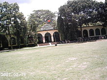
- Adina College and Idrishi Bhaban
- Zannat View,zannatnagar,Dadanchak
- Pukhuria Village and Shahanbandha Lake(Pukhur) in shibganj Subdivision,
- Hindu Temple in Town centre on way to HariMohan High School,
Educational institutions
This is a small District in Bangladesh with some good educational institutions. Idris Ahmed Miah M.L.A is the Father of education in this district.
PTI (Primary Teachers' Training Institute)
Dadanchak F.H.PTI (1938)- Founded by Idris Ahmed Miah M.L.A
Nawabganj PTI (1974)- First It was founded at Dadanchak as a women's PTI by Iqbal Ahmed Miah, elder son of Idris Ahmed Miah.
Colleges
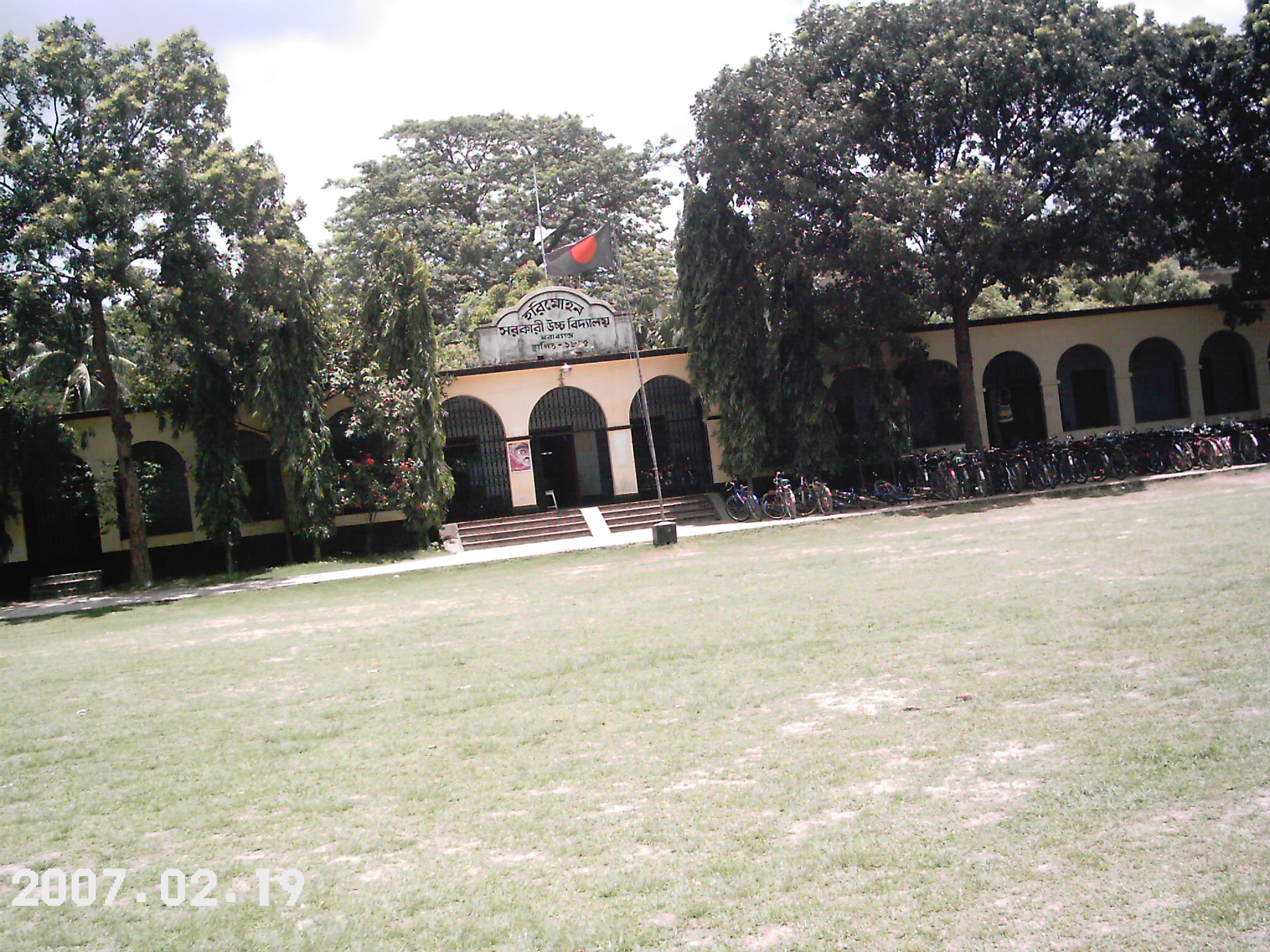
 Harimohon Govt. High School
1. Nawabganj Government College(নবাবগঞ্জ মহাবিদ্যালয়). 2. Nawabganj Government Women's College(নবাবনঞ্জ মহিলা মহাবিদ্যালয়). 3. Captain Mohiuddin Jahangir (Birshreshtho) College(ক্যাপ্টেন মহিউদ্দিন জাহাংগীর বীরশ্রেষ্ঠ মহাবিদ্যালয়) 4. Shah Neyamotullah College(শাহ নেয়মুতুল্লা মহাবিদ্যালয়) 5. Adina Fazlul Haque College (1938)It was founded by renowned politician Idris Ahmed Miah M.L.A and Honours courses is introduced by his grandson Ittehad Tawheedul Idrishi (Collins) in the academic year 2006-2007.
6. Rohanpur Yeasuf Ali College (1967) (Gomostapur) 7. Kansat Soleman Degree College (1968)(Shibganj) 8. Nawabganj City Collage (1996). 9. Shympur Degree College (Shibganj) 10.Sonamosjid Degree college(Shibganj) 11.Shahbajpur Degree College(Shibganj) 12.Chakkirty Degree College(Shibganj) 13.Pukuria Women College(Shibganj) 14.Binodpur Degree College(Shibganj)
High schools
chamagram H.N.high school
- Rajarampur Hamidullah High School, Rajarampur
- Dadanchak Bel-Afroz Idrishi Girl's High School (1910) Founded by Idris Ahmed Miah
- Nawabganj Harimohon Government High School.
- Nawabganj Government Girls High School(নবাবগঞ্জ সরকারি বালিকা উচ্চ বিদ্যালয়).
- Namo Sonkarbati High School(নামো শংকরবাটি উচ্চ বিদ্যালয়).
- Kamal Uddin Girls' High School(কামাল উদ্দিন উচ্চ বিদ্যালয়).
- Nawabganj Town High School.
- Fulkuri Islamic Academy.
- Bholahat Rameshwar Pilot High School (1911).
- Kansat High School (1917).
- Dadanchak HM High School (1919).Founded by Idris Ahmed Miah
- AB Government High School,R
Harimohan High School Nawabganj __________________________________ Harimohan High School produced several scholars among them 1. Ajit kumar Ghosh who became principal of Howrah Girls College near Kolkata India. 2.Dr Ranajit kumar Ghosh became a Doctor graduating from famous NRS Medical College of Kolkata and practised medicine in Malda India. 3. Santosh Kumar Ghosh stood first in Matriculation Examination in Rajshahi District and studied Architecture at famous BE College in Shibpur near Kolkata and went to USA to get M Arch. He became Chief Architect of Kolkata,India. 4. Dr Jayanti Kumar Ghosh stood first in Matriculation examination and got district schlarship.He became a Doctor graduating from famous NRS Medical college of Kolkata. He went to England and settled in UK and worked in UK NHS. He is a fellow of the Royal Society of Medicine London.He was also chairman of South Northumberland British Medical Association. Above mentioned 4 former students of Harimohan High School are sons of famous lawyer and politician Ramesh Chandra Ghosh.
Among notable teachers after independence: Naimul Hoque- Headmaster, Gias Mia-Maths Teacher, Bhola Saha-Sanskrit teacher and School Accountant, Spotrs Organiser Teacher- Roychowdhury.
Madrasa
- Nawabganj Alia Madrasa (Kamil) (1964).
References
- ^ http://www.dcchapainawabganj.gov.bd/
- ^ Banglapedia
- ^ Google Map
- ^ Toru (2007-04-23). "Chapai Nawabganj". Banglapedia. http://www.bpedia.info/G_0011.php. Retrieved 2009-11-11.
- ^ [1], Banglapedia published by Asiatic Society Bangladesh.
- ^ [2], This portal is storing picture
- ^ [3], National Encyclopedia of Bangladesh
 Divisions and districts of Bangladesh
Barisal Division 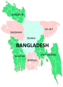
Chittagong Division Bandarban · Brahmanbaria · Chandpur · Chittagong · Comilla · Cox's Bazar · Feni · Khagrachari · Lakshmipur · Noakhali · RangamatiDhaka Division Dhaka · Faridpur · Gazipur · Gopalganj · Jamalpur · Kishoreganj · Madaripur · Manikgonj · Munshiganj · Mymensingh · Narayanganj · Narsingdi · Netrokona · Rajbari · Shariatpur · Sherpur · TangailKhulna Division Rajshahi Division Rangpur Division Sylhet Division Categories:- Chapai Nawabganj District
- Districts of Bangladesh
- Nawabganj District
- Populated places in Bangladesh


Wikimedia Foundation. 2010.