- Chittagong Division
-
Chittagong Division
চট্টগ্রাম— Division — Map of Chittagong Division
Coordinates: 22°55′N 91°30′E / 22.917°N 91.5°ECoordinates: 22°55′N 91°30′E / 22.917°N 91.5°E Country  Bangladesh
Established Area - Total 33,771.18 km2 (13,039.1 sq mi) Population (2011 census) - Total 28,079,000 - Density 831.4/km2 (2,153.4/sq mi) Time zone BST (UTC+6) Chittagong Division (Bengali: চট্টগ্রাম) is geographically the largest of the seven administrative divisions of Bangladesh. It covers the most south-eastern areas of the country, with a total area of 33,771.18 km² and a population at the 2011 Census (preliminary result) of 28,079,000.
Contents
Administrative Districts
The Division is subdivided into eleven districts (zilas) and thence into 99 sub-districts (upazilas). The first six districts listed below comprise the north-western portion (37.6%) of the Division, while the remaining five comprise the south-eastern portion (62.4%), the two portions being separated by the lower (or Bangladeshi) stretch of the Feni River; the upland districts of Khagrachhari, Rangamati and Bandarban together comprise that area previously known as the Chittagong Hill Tracts.
Name Capital Area (km²) Population
1991 CensusPopulation
2001 CensusPopulation
2011 Census
(preliminary
results)Brahmanbaria District Brahmanbaria 1,927.11 2,141,745 2,398,254 2,808,000 Comilla District Comilla 3,085.17 4,032,666 4,595,539 5,304,000 Chandpur District Chandpur 1,704.06 2,032,449 2,271,229 2,393,000 Lakshmipur District Lakshmipur 1,455.96 1,312,337 1,489,901 1,711,000 Noakhali District Noakhali 600.99 2,217,134 2,577,244 3,072,000 Feni District Feni Sadar 928.34 1,096,745 1,240,384 1,420,000 Chittagong District Chittagong 5,282.98 5,296,127 6,612,140 7,509,000 Khagrachhari District Khagrachhari 2,699.55 342,488 525,664 608,000 Rangamati District Rangamati 6,116.13 401,388 508,182 596,000 Bandarban District Bandarban 4,479.03 230,569 298,120 383,000 Cox's Bazar District Cox's Bazar 2,491.86 1,419,260 1,773,709 2,275,000 Total Division Chittagong 33,771.18 20,552,908 24,290,384 28,079,000 Literacy
The Literacy rate is 22.08%.
Sources
Census figures for 1991, 2001 and 2011 are from Bangladesh Bureau of Statistics, Population Census Wing. The 2011 Census figures are based on preliminary results.
See also

Dhaka Division Sylhet Division
Tripura, IndiaBarisal Division 
Mizoram, India  Chittagong Division

Bay of Bengal Chin State, Myanmar
Rakhine State, Myanmar Divisions and districts of Bangladesh
Barisal Division 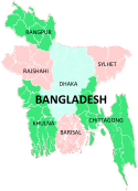
Chittagong Division Bandarban · Brahmanbaria · Chandpur · Chittagong · Comilla · Cox's Bazar · Feni · Khagrachari · Lakshmipur · Noakhali · RangamatiDhaka Division Dhaka · Faridpur · Gazipur · Gopalganj · Jamalpur · Kishoreganj · Madaripur · Manikgonj · Munshiganj · Mymensingh · Narayanganj · Narsingdi · Netrokona · Rajbari · Shariatpur · Sherpur · TangailKhulna Division Rajshahi Division Rangpur Division Sylhet Division Categories:- Chittagong Division
- Divisions of Bangladesh
- Bangladesh geography stubs


Wikimedia Foundation. 2010.