- Chittagong Hill Tracts
-
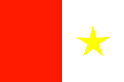 Flag of the Chittagong Hill Tracts
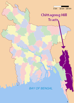
The Chittagong Hill Tracts (Bengali: পার্বত্য চট্টগ্রাম Parbotto Chôṭṭogram) comprise an area of 13,295 km2 in south-eastern Bangladesh, and borders India and Myanmar (Burma). It was a single district of Bangladesh until 1984. In that year it was divided into three separate districts: Khagrachari, Rangamati and Bandarban. Topographically, this is the only hill intensive area of Bangladesh. It is one of the few remaining abodes of Buddhism in South Asia, including Ladakh, Bhutan and Sri Lanka.[citation needed]
Contents
Demography
According to the 1991 census the population was 974,447 of which 501,114 were tribals and the rest were from different communities. The tribal peoples, collectively known as the Jumma, include the Chakma, Marma, Tripura, Tenchungya, Chak, Pankho, Mru, Murung, Bawm, Lushai, Khyang, Gurkha, Assamese, Santal and Khumi.[1]
The current population of the three districts (zilas) is 1,587,000 at the 2011 Census (provisional returns). About 50% of the population are tribals and mainly followers of Theravada Buddhism. 48% of the inhabitants are Bengali Muslims. The remainder are followers of Hinduism, Christianity and Animism.[1] At the time of the partition of India in August, 1947 non MusIims constituted 98.5% of the population of the Chittagong Hill Tracts. Buddhists were 85%, Hindus (mainly Tripuri tribe) 10%, Animists 3% and Muslims 1.5%
History
See also: Chittagong Hill Tracts Conflict Bandarban.
The early history of the Chittagong Hill Tracts, a part of the Chin National Territory, is a record of constantly recurring raids on the part of the eastern hill tribes, and of the operations undertaken to repress them. The earliest mention of these raids is to be found in a letter from the Chief of Chittagong to Warren Hastings, the Governor-General, dated April to, 1777,' complaining of the violence and aggressions of a mountaineer, the leader of a band of Kukis or Lushais ; and that they continued without any long intermission down to 1891 when the Lushai Hills were annexed to British territory. The recorded population increased from 69,607 in 1872 to 101,597 in 1881, to 107,286 in 1891, and to 124,762 in 1901. The Census of 1872 was, however, very imperfect, and the actual growth of population has probably not exceeded what might be expected in a sparsely inhabited but fairly healthy tract.[2] on the time of parthion Chittagong Hill Tracts had a majority non-Muslim population of 97% (most of them Buddhists), but was given to Pakistan. The Chittagong Hill Tracts People's Association (CHTPA) petitioned the Bengal Boundary Commission that, since the CHTs were inhabited largely by non-Muslims, they should remain within India.[citation needed] Since they had no official representation, there was no official discussion on the matter, and many on the Indian side assumed the CHT would be awarded to India.
On 15 August 1947, many of the tribes did not know to which side of the border they belonged. On 17 August, the publication of the Radcliffe Award put the CHTs in Pakistan. The rationale of giving the Chittagong Hill Tracts to Pakistan was that they were inaccessible to India and to provide some buffer area to Chittagong (now in Bangladesh), a major city and port; it was also argued that its only approach was through Chittagong.
"Two days later, the CHTPA resolved not to abide by the award and hoisted the Indian flag. The Pakistani army dealt with the protest but the problem has not yet been solved.
When the 1901 census was taken there were no towns, and 211 of the villages had a population of less than 500, while only one exceeded 2,000. The population density, excluding the area of uninhabited forest (1,385 square miles), was 33 persons per square mile. There was a little immigration from Chittagong, and a few persons had emigrated to Tripura. The proportion of females to every 100 males was only 90 in the district-born, and 83 in the total population. Buddhists numbered 83,000, Hindus 36,000, and Muslims 5,000.[3]The Chittagong Hill Tracts, combining three hilly districts of Bangladesh, were once known as Korpos Mohol, the name used until 1860. In 1860 it was annexed by the British and was made an administrative district of Bengal. As of today, it is a semi-autonomous region within Bangladesh comprising the districts, namely, Chengmi (Khagrachari District), Gongkabor (Rangamati District), and Arvumi (Bandarban District).
The last Viceroy, Lord Mountbatten, who considered the grant of independence to India as his act of crowning glory, was ambitious to achieve this "superhuman" task in record time. He said that before accepting the post of Viceroy he had told King George VI, who was his cousin: "I am prepared to accept the job only on one condition. India must be granted independence by July, 1948 and I will not stay there a day longer". Mountbatten came to India in March, 1947 and this left him just about sixteen months to complete such a gigantic task. In reality, he achieved it in five months, on 15 August, 1947 for which he was given so much credit.
Originally, the award of the Boundary Commission was to be made public on 13 August. But Mountbatten was reluctant to make this public. According to Philip Ziegler, the author of Mountbatten's official biography, the case of the Chittagong Hill Tracts was uppermost in Mountbatten's mind. "He (Mountbatten) foresaw an Independence Day marred by rancour, Nehru boycotting the ceremonies, India born in an atmosphere not of euphoria but of angry resentment. So Mountbatten decided to announce the award only on 16 August when the celebrations were over. As Zeigler writes, "India's indignation at the award of the Chittagong Hill Tracts to Pakistan may have been a factor in making up Mountbatten's mind to keep the reports to himself till after independence".
Mountbatten was himself surprised by the ferocity of Sardar Patel's reaction to the issue. In his memoirs he wrote: "The one man I had regarded as a real statesman with both his feet firmly on the ground, and a man of honour whose word was his bond, had turned out to be as hysterical as the rest. Candidly I was amazed that such a terrific crisis should have blown up over so small a matter. However, I have been long enough in India to realise that major crises are by no means confined to big matters." Leonard Mosley in his book The Last Days of the British Raj puts it "This is a matter for Mountbatten's conscience.
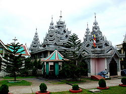 Rajban Vihara (Buddhist Monastery), Rangamati
During the 1970s and 80s, there were attempts by the Government to resettle the area with Bengali people. These attempts were resisted by the tribals, who, with the latent support of neighbouring India, formed a guerilla force called Shanti Bahini. As a result of the tribal resistance movement, successive governments turned the Hill Tracts into a militarised zone. Professor Bernard Nietschmann wrote a letter about Shanti Bahini and the Chittagong Hill Tracts people to the editor of the New York Times by published on October 25, 1986 (archived by the Fourth World Documentation Project) at the Center for World Indigenous Studies website.
Bengali settlers and soldiers have been accused of human rights violations against the tribal minorities, including the massacre of civilians, extrajudicial killings, torture, and, more recently, the imprisonment of non-violent activists.[4] Members of the Shanti Bahini and other rebel groups have committed similar violations, including the massacre of unarmed Bengali settlers.[4]
Following years of unrest, an agreement was formed between the Government of Bangladesh and the tribal leaders which granted a limited level of autonomy to the elected council of the three hill districts.
 The Hanging Bridge, Rangamati
The 1997 Peace Treaty signed between the then Sheikh Hasina Government and the Jana Shanghati Shamiti or Shanti Bahini has been opposed by the opposition parties as well as a fraction of the tribal rebels[citation needed]. Opposition parties of the time argued that the autonomy granted in the treaty ignored the Bengali settlers. The successive Khaleda Zia government promised to implement the peace treaty, despite their opposition to it during the previous government's term. According to the Ministry of Chittagong Hill Tracts Affairs, a Peace Treaty between the Government of Bangladesh and Parbattya Chattagram Jana Samhati Samiti was signed on 2 December 1997. However, Shanti Bahini rebels kept on committing killings and harassing the Bengali people living in the area. There are many accusations that they get financial help from a foreign country to fight for their freedom. [1]
Tobacco cultivation
Tobacco cultivation is damaging the ecology of the area, with loss of trees and soil fertility. Many of the farmers of Rangamati, Bandarban and Khagrachhari districts of Bangladesh have been losing their interests in cultivating indigenous crops like paddy, banana, maize, sesame, cotton, potato, pumpkin etc. as they became defaulters of loans provided by tobacco companies, they said.[1]
See also
Bibliography
- Shelly, Mizanur Rahaman. (1992). The Chittagong Hill Tracts of Bangladesh: The Untold Story. Dhaka, Bangladesh: Centre for Development Research, Bangladesh.
- Life is not Ours: Land and Human Rights in the Chittagong Hill Tracts, Bangladesh. Copenhagen, Denmark: Organizing Committee, Chittagong Hill Tracts Campaign, 1991.
- Brauns, Claus-Dieter, "The Mrus: Peaceful Hillfolk of Bangladesh", National Geographic Magazine, February 1973, Vol 143, No 1
References
External links
- Official website of The Chittagong Hill Tracts Commission
- Banglapedia article on Chittagong Hill Tracts
- Survival International
- Ali, M. Emran and Toshiyuki Tsuchiya, Land Rights of the Indigenous People of the Chittagong Hill Tracts in Bangladesh: A Historical Analysis of Policy Issues. Fourth World Journal, Volume 5, Number 1.
- Rahman Nasir Uddin, General Concept about Jhum Cultivation and the Role of Media
- S. Dewan, Horrors in the Chittagong Hilltracts. Center For World Indigenous Studies.
- Jumma People Network - UK
- Jumma People Network - USA
- Refugees Within, Refugees Without
- Chittagong Hill Tracts: Ceremonies and Lives (Videos)
- Chittagong Hill Tracts: Slideshow (Photographs)
- J.P. Mills and the Chittagong Hill Tracts, 1926/27 (Tour Diary, Reports, Photographs)
- A worldwide campaign for the indigenous people in Chittagong Hill Tracts - 100, 000 Global Voices for Peace in the CHT
Mountains and Plateaus Himalayas · Western Ghats · Eastern Ghats · Aravalli Range · The Nilgiris · Vindhya Range · Satpura Range · Garo Hills · Shivalik Hills · Mahabharat Range · Khasi Hills · Annamalai Hills · Cardamom Hills · Sulaiman Mountains · Toba Kakar Range · Karakoram · Hindu Kush · Chittagong Hill Tracts · Deccan Plateau · Thar Desert · Makran · Chota Nagpur · Naga Hills · Mysore Plateau · Ladakh Plateau · Gandhamardan HillsLowlands and Islands Indo-Gangetic plain · Indus River Delta · Ganges Basin · Ganges Delta · Terai · Atolls of Maldives · Coromandel Coast · Konkan · Lakshadweep · Andaman and Nicobar Islands · Sundarbans · Greater Rann of Kutch · Little Rann of Kutch · Protected areas in Tamil NaduCountries Categories:- Chittagong
- Geography of Bangladesh
- Mountain ranges of Asia
- Indigenous land rights


Wikimedia Foundation. 2010.