- Sulaiman Mountains
-
Coordinates: 30°30′N 70°10′E / 30.5°N 70.167°E
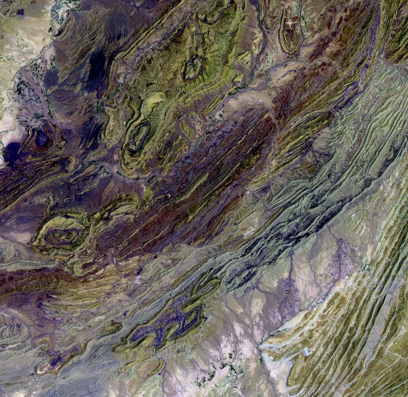
 Satellite image of a part of the Sulaiman Range.
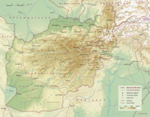
The Sulaiman Mountains are a major geological feature of northern Balochistan province of Pakistan and Zabul province of Afghanistan. It is the bordering region between the Iranian Plateau and the Indian subcontinent, located to the east of the Lut Desert and to the west of the Indus River. Bordering the Sulaiman Range to the north are the arid highlands of the Hindu Kush, with more than 50 percent of the lands there lying above 2,000 m (6,500 feet). The highest peak of Sulaiman Mountains is Takht-e-Sulaiman, 3,487 metres (11,440 ft) in Balochistan, Pakistan. In comparison, the highest point in Balochistan, at 3,578 metres (11,739 ft), is Zarghoon Ghar in Quetta.[1]
The Sulaiman Range, [2] and the high plateau to the west and southwest of it, helps form a natural barrier against the humid winds that blow from the Indian Ocean, creating arid conditions across Southern Afghanistan to the north. In contrast, the relatively flat and low-lying Indus Delta is situated due east and south of the Sulaiman Mountains. This lush delta is prone to heavy flooding and is mostly uncultivated wilderness.
Contents
Range
Takht-e-Sulaiman 3,483 metres (11,427 ft), Koh-i-Takatu 3,472 metres (11,391 ft), Kaisargarh 3,444 metres (11,299 ft), and Giandari are some of the mountain peaks in the Sulaiman range. The mountain range enters in Punjab in Dera Ghazi Khan district and approaches the Indus river near Mithankot in Rajanpur district of Punjab.
Legends
The legend of the Sulaiman mountain range is east of Quetta (Pakistan), overlooking the plain of the Indus river. One of the highest peaks (11,085 feet) is called Takht-i Sulaiman, meaning Solomon's Throne. Ibn Battuta names it Koh-i Sulaiman. [3] it is related, that the Prophet of God, Hazrat Sulaiman climbed this mountain and looked out over the land of South Asia, which was then covered with darkness - but he turned back without descending into this new frontier, and left only the mountain which is named after him. (From Ibn Battuta)
Local inhabitants believe that Prophet Sulaiman, by exercising his miraculous power, had confined those mischievous Jinns inside it who had refused to obey his command. The evil-spirited Jinns are supposed to remain imprisoned almost all the year, and in Safar, the second month of the Islamic calendar, they are allowed to go free for a while. During this month, after darkness falls over the region, mothers restrict their children within their homes as a precaution against the evil effects of these Jinns.[4]
Al-Biruni writes of this mountain range in his memoirs as being the western frontier mountains of South Asia and the homeland of the people known as the Afghans or Pashtuns.
See also
- Mountain ranges of Pakistan
- List of mountain ranges of the world
- List of mountains in Pakistan
- List of highest mountains (a list of mountains above 7,200m)
- Fort Munro
References
- ^ http://www.caab.20m.com
- ^ http://www.multimap.com/wi/browse.cgi?client=public&X=7800000.66810007&Y=3200000.05385919&width=500&height=300&gride=&gridn=&srec=0&coordsys=mercator&db=&addr1=&addr2=&addr3=&pc=&advanced=&local=&localinfosel=&kw=&inmap=&table=&ovtype=&zm=0&scale=4000000&up.x=189&up.y=4
- ^ http://earthobservatory.nasa.gov/Newsroom/NewImages/images.php3?img_id=10780
- ^ http://www.deraismailkhan.org/solomans-peak-koh-i-sulaiman.html
- Chiltan Adventures Association Balochistan; http://www.caab.20m.com
- Original entry was from the NASA Earth Observatory; [1]
- Sulaiman Range at multimap; [2]
External links
The Mountain Ranges of the Iranian Plateau and their Political Geography Alborz Mountains Zagros Mountains Taurus Mountains Hindu Kush Mountains Sulaiman Mountains Caucasus Mountains Mountains and Plateaus Himalayas · Western Ghats · Eastern Ghats · Aravalli Range · The Nilgiris · Vindhya Range · Satpura Range · Garo Hills · Shivalik Hills · Mahabharat Range · Khasi Hills · Annamalai Hills · Cardamom Hills · Sulaiman Mountains · Toba Kakar Range · Karakoram · Hindu Kush · Chittagong Hill Tracts · Deccan Plateau · Thar Desert · Makran · Chota Nagpur · Naga Hills · Mysore Plateau · Ladakh Plateau · Gandhamardan HillsLowlands and Islands Indo-Gangetic plain · Indus River Delta · Ganges Basin · Ganges Delta · Terai · Atolls of Maldives · Coromandel Coast · Konkan · Lakshadweep · Andaman and Nicobar Islands · Sundarbans · Greater Rann of Kutch · Little Rann of Kutch · Protected areas in Tamil NaduCountries Beas River · Chenab River · Chhachh · Cholistan Desert · Doaba · Ganji Bar · Ghaggar river · Indus River · Jhelum River · Kachhi · Kallar Kahar · Khewra Salt Mines · Kirana Bar · Kirana Hills · Majha · Malwa · Margalla Hills · Murree · Neeli Bar · Pothohar Plateau · Powadh · Ravi River · Salt Range · Sandal Bar · Sivalik Hills · Soon Valley · Sulaiman Mountains · Sutlej River · Thal Desert · Trimmu Categories:
- Mountain ranges of Asia
- Mountain ranges of Pakistan
- Sulaiman Range
- South Asia

Wikimedia Foundation. 2010.