- Zabul Province
Geobox|Province
country = Afghanistan
country_
name = Zabul
native_name = زابل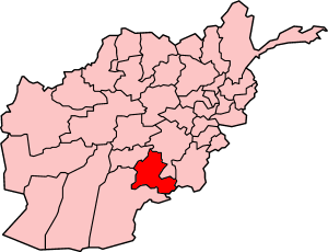
map_caption = Map of Afghanistan with Zabol highlighted
capital = Qalat
capital_lat_d = 32.1
capital_long_d = 67.1
population_as_of = 2004
population = 365920
population_note = [http://www.statoids.com/uaf.html Provinces of Afghanistan] on [http://www.statoids.com/ Statoids] .] [ [http://afghanistan.usaid.gov/en/Province.34.aspx Afghanistan's Provincesndash Zabul at USAID] ]
area = 17343
density =
timezone = UTC+4:30
free_type = Main language
free = PashtoZabul ( _ps. زابل) is a historic province of
Afghanistan . Zabul became an independent province from neighbouring Kandahar in 1963, with Qalat being named the provincial capital. It should not be confused with a new small cityZabol in Irani Afghan border.Political and security situation.
With its sparse population, insecure border with
Pakistan and little central authority, Zabul is a fertile ground for insurgents fighting against the current Afghan government, although the province is considered more secure than some of its southern neighbours [http://www.theglobeandmail.com/servlet/story/RTGAM.20060623.wxafghan23/BNStory/International/home] . The province has especially struggled with retainingNGO 's and teachers in the face ofTaliban attacks and threats. Until 2006, the only major international presence was an AmericanProvincial Reconstruction Team (PRT) based in Qalat coord|32|07|47|N|066|55|41|E|type:PRT:U.S., when it was joined by aUNAMA branch.The current governor of the province is
Del Bar Jan Arman .Geography and population
The population of the province was reported to be 365,920 in 2004, and the province covers an area of 6,590 square miles [http://www.culturalprofiles.org.uk/Afghanistan/Units/132.html] .
Districts
*
Argahandab District
*Atghar District
*Dey Chopan District
*Mizan District
*Qalat District
*Shahjoy District
*Shamulzayi District
*Shinkay District
*Tarnak Wa Jaldak District Cities
*Qalat
*Shajuiy Transportation
In 2006, the province's first airstrip was opened near Qalat, to be operated by the
Afghan National Army , but also for use by commercial aviation. Twice weekly service was scheduled byPRT Air between Qalat andKabul . The airstrip is not paved. [ [http://afghanistan.usaid.gov/en/Article.73.aspx First Airstrip in Zabul Province] , " [http://afghanistan.usaid.gov/ USAID] ".]References
See also
*
Jayapala
*Abu Ali Lawik
*Zabol

Wikimedia Foundation. 2010.