- Nuristan Province
-
- This page is about the province in Afghanistan. Nuristan is also a proposed name of Khyber-Pakhtunkhwa Province of Pakistan.
Nuristan (نورستان) Province 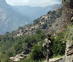 The village of Aranas in Nuristan
Country Afghanistan Population 112,000 [1] Governor Jamaluddin Badar Timezone GMT+4:30 Main language Pashto , Nuristani 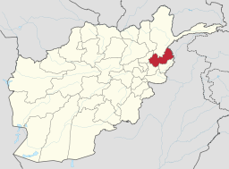 Map of Afghanistan with Nuristan highlighted
Nuristān (Persian:نورستان), also spelled Nurestān or Nooristan, is a region in Afghanistan embedded in the south of the Hindu Kush valleys. Its administrative center is Parun. It was formerly known as Kafiristan ("land of the unbelievers") until the inhabitants were converted to Islam in 1896, and thence the region has become known as Nuristan ("Land of Light").[2]
Today it is one of the thirty-four provinces of Afghanistan, formed in 1989 and officially established in 2001 from the northern parts of Laghman Province and Kunar Province. Its administrative center, Parun, is located in the Parun valley. Before 2001 its capital was situated in Laghman province due to Mujahideen control over Nuristan province.
The primary occupations are agriculture, animal husbandry, and day labor. Located on the southern slopes of the Hindu Kush mountains in the northeastern part of the country, Nuristan spans the basins of the Alingâr, Pech, Landai Sin, and Kunar rivers. It is bordered on the north by Badakhshan Province, on the south by Laghman and Kunar provinces, on the west by Panjshir Province, and on the east by Pakistan.
Contents
History
Until the 1890s, the region was known as Kafiristan (Persian for "Land of the non-believers") because of its inhabitants: the Nuristani, an ethnically distinctive people (numbering about 60,000) who practiced animism, polytheism and shamanism.[2]
Advent of Islam
The region was conquered by Emir Abdur Rahman Khan in 1895–96 and the Nuristani were then converted to Islam.
“ The Kafirs are thought to be the original inhabitants of the plains country of Afghanistan in what is now Nuristan. They were driven back into the mountain areas by the arrival of Islam in the country about 700AD. They are thought to be the descendents of the old native population that used to occupy the region, and they did not convert to Islam with the rest of the population, remaining pagan for several more centuries. [3] ” British Missionaries wrote:
“ The Kafirs were largely independent until the late nineteenth century, when the region was attacked by the forces of Abdur Rahman and the population was more forcibly converted to Islam .[4] ” “ They had only been converted to Islam as late as the 1890s , at the point of the sword [5] ”
The region was renamed Nuristan, meaning Land of the Enlightened, a reflection of the "enlightening" of the pagan Nuristani by the "light-giving" of Islam.Nuristan was once thought to have been a region through which Alexander the Great passed with a detachment of his army; thus the folk legend that the Nuristani people are direct descendants of Alexander (or "his generals").
Abdul Wakil Khan Nuristani is one of the most prominent figures in Nuristan's history. He fought against the British army and drove them out of the eastern provinces of Afghanistan. His monument stands in Chahrahi Dehmazung in the capital Kabul, Afghanistan. He is buried on the same plateau where King Amanullah Khan is buried.
Nuristan was the scene of some of the heaviest guerrilla fighting during the 1979–89 invasion and occupation of Afghanistan by Soviet forces. For a period of time during this era, the eastern area of Nuristan was a semi-autonomous region called the Islamic Revolutionary State of Afghanistan, or Dawlat. It was a Wahhibist Islamic state run by anti-Soviet warlord Maulvi Afzal and was recognized by Saudi Arabia and Pakistan. The Dawlat dissolved under Taliban rule. [6]
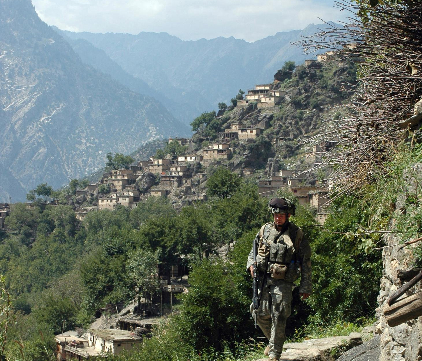
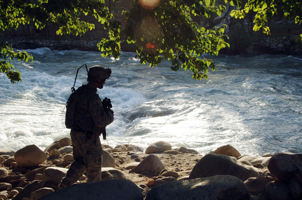
 A U.S. soldier conducts a patrol through the village of Kowtalay in the Nuristan province.
Nuristan is one of the poorest and most remote provinces of Afghanistan. Few NGO's operate in Nuristan because of a poor security situation and lack of infrastructure. Largely in response to a publicity campaign by Nuristan's first governor, Tamim Nuristani, roads are being built between Nangarej, Mandol and Chapa Dara to Titan Dara.[7] Nuristani also worked on a direct road route to Laghman province, in order to reduce dependence on the road through restive Kunar province to the rest of Afghanistan.
Since Nuristan is a highly ethnically homogeneous province, there are few incidents of inter-ethnic violence. However, there are instances of disputes between inhabitants, some of which continue for decades. Nuristan has suffered from its inaccessibility and lack of infrastructure. The government presence is under-developed, even compared to neighboring provinces. Nuristan's formal educational sector is weak, with few professional teachers. Due to its proximity to Pakistan, many of the inhabitants are actively involved in trade and commerce across the border.
Demographics
The population of around 300,000 people is 95% Nuristani and 5% Pashtun/Tajik.[8][9] 30% of the population speak Dari or Pashto and 90% speak the following Nuristani languages:[10]
- Askunu language
- Kamkata-viri language
- Vasi-vari language
- Tregami language
- Kalasha-ala language
Pashayi language is spoken by 15% people.[10]
The main Nuristani tribes in the province are Katta (38%), Kalasha (30%), Ashkori or Wamayee (12%), Kam (10%), Satra (5%), and Parsoon (4%).
Districts
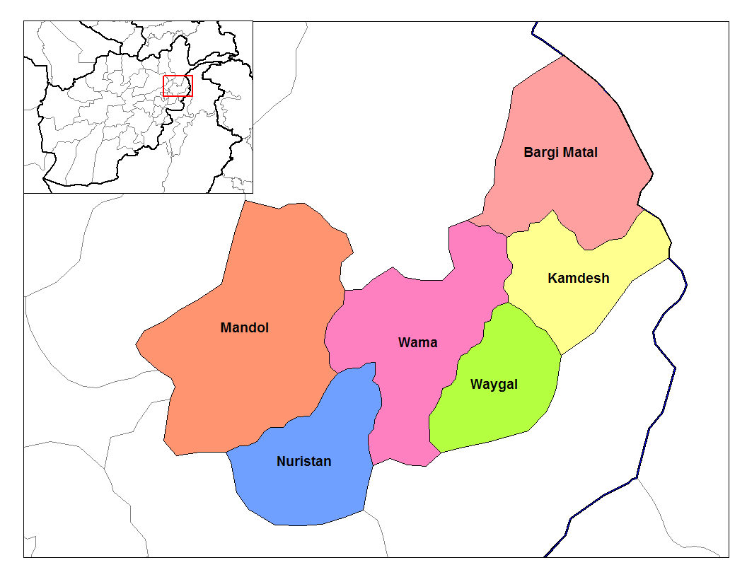
 Districts of Nuristan.
Districts of Nuristan Province District Capital Population [10] Area[11] Notes Bargi Matal Du Ab Est. 2004 formerly part of Nuristan District and Mangol District Kamdesh Kamdish Mandol Lost territory to Du Ab District in 2004 Nurgram Est. 2004 formerly part of Nuristan District and Wama District Parun Est. 2004 formerly part of Wama District Wama Lost territory to Parun District and Nurgram District in 2004 Waygal Politics
From 2005 Mohammad Tamim Nuristani was governor of Nuristan Province but was fired by Afghan president Hamid Karzai in July 2008. His replacement as governor, Hazrat Din Noor, was killed in a car crash on September 5, 2008.[12] The current governor is Jamaluddin Badar.
Operation Enduring Freedom
A map from the Ministry of the Interior produced on August 5, 2009 showed the western region of Nuristan to be under “enemy control”. There have been numerous conflicts between the Taliban, at times in tandem with other militias, and coalition forces. On 06 April, 2008 elements of the 3rd Special Forces Group led Afghan soldiers from the Commando Brigade into the Shok valley in an unsuccessful attempt to capture the leader of the insurgent group Hezb-e-Islami Gulbuddin, Gulbuddin Hekmatyar. On July 13, 2008 approximately 200 Taliban guerrillas attacked a NATO position just south of Nuristan, near the village of Wanat in the Waygal district, killing 9 coalition soldiers.[13] In the following year, in early October, more than 350 Taliban fighters backed by members of the Hezb-i-Islami Gulbuddin and other militia groups fought US soldiers and Afghan police in the Battle of Kamdesh at Camp Keating in Nuristan. The base was nearly overrun; more than 100 Taliban fighters, eight US soldiers, and seven Afghan security officers were killed during the fighting.[14][15][16][17] Four days after the battle, in early October 2009, U.S. forces withdrew from their four main bases in Nuristan, as part of a plan by General Stanley McChrystal to pull troops out of small outposts and relocate them closer to cities.[18] The U.S. has pulled out from some areas in the past, but never from all four main bases.[19] A month after the U.S. pullout the Taliban was governing openly in Nuristan.[20]
In popular culture
- Nuristan is the subject of the book A Short Walk in the Hindu Kush by the British travel writer Eric Newby.
- Nuristan was the location of three of the missions in Hitman 2: Silent Assassin.
- Rudyard Kipling's short story The Man Who Would Be King and the film inspired by it are set in pre-Islamic Nuristan.
External sources
References
- ^ Provinces of Afghanistan on Statoids.
- ^ a b Klimberg, Max (October 1, 2004). "NURISTAN". Encyclopædia Iranica (Online Edition ed.). United States: Columbia University. http://www.iranica.com/newsite/articles/unicode/ot_grp6/ot_nuristan_20041001.html.
- ^ Conflict in Afghanistan: a historical encyclopediaBy Frank Clements, Ludwig W. Adamec Edition: illustrated Published by ABC-CLIO, 2003 Page 139 ISBN 1851094024, 9781851094028
- ^ Conflict in Afghanistan: a historical encyclopediaBy Frank Clements, Ludwig W. Adamec Edition: illustrated Published by ABC-CLIO, 2003 Page 139 ISBN 1851094024, 9781851094028
- ^ A passage to Nuristan: exploring the mysterious Afghan hinterland By Nicholas Barrington, Joseph T. Kendrick, Reinhard Schlagintweit Edition: illustrated Published by I.B.Tauris, 2006 Page Preface xiii ISBN 1845111753, 9781845111755
- ^ Daan Van Der Schriek Nuristan: Insurgent Hideout in Afghanistan, Terrorism Monitor, Volume 3, Issue 10 (May 19, 2005)
- ^ Nuristan governor, contractor, and Afghanistan engineer district sign partnership agreement, Headquarters US Central Command, News Release, June 13, 2006
- ^ Nuristan Province on nps.edu
- ^ Nuristan Tribal Map on nps.edu
- ^ a b c Nuristan provincial profile profile compiled by the National Area-Based Development Programme (NABDP) of the Ministry of Rural Rehabilitation and Development (MRRD)
- ^ Afghanistan Geographic & Thematic Layers
- ^ [1][dead link]
- ^ "Taliban fighters storm US base". Al Jazeera. http://english.aljazeera.net/news/asia/2008/07/200871463317512597.html. Retrieved 2008-07-16.
- ^ Taliban govern openly in Nuristan, Bill Roggio, Long War Journal, 2009-11-12
- ^ Taliban Claim to Seize American Arms, Robert Mackey, New York Times, 2009-11-12
- ^ Eight U.S. Troops Die in Attack on Afghan Outpost, Joshua Partow, Washington Post, 2009-10-04
- ^ Heavy US losses in Afghan battle, Martin Patience, BBC News, Kabul, 4 October 2009
- ^ Kamdesh ambush played out like Wanat battle, Matthew Cox and Michelle Tan, Army Times, November 3, 2009
- ^ Asia Times Online :: South Asia news, business and economy from India and Pakistan. Atimes.com (2009-10-29). Retrieved on 2011-02-07.
- ^ Taliban govern openly in Nuristan, Bill Roggio, Long War Journal, 2009-11-12
- Dupree, Nancy Hatch (1977): An Historical Guide to Afghanistan. 1st Edition: 1970. 2nd Edition. Revised and Enlarged. Afghan Tourist Organization. LINK
- Richard F. Strand. Richard Strand's Nuristan Site LINK. The most accurate and comprehensive source on Nuristan, by the world's leading scholar on the languages and ethnic groups of Nuristan.
- M. Klimburg. NURISTAN in Encyclopedia Iranica. LINK
See also

Badakhshan Province Khyber Pakhtunkhwa,  Pakistan
Panjshir Province 
 Nuristan Province

Laghman Province Kunar Province Provinces of Afghanistan Badakhshan · Badghis · Baghlan · Balkh · Bamyan · Daykundi · Farah · Faryab · Ghazni · Ghor · Helmand · Herat · Jowzjan · Kabul · Kandahar · Kapisa · Khost · Kunar · Kunduz · Laghman · Logar · Nangarhar · Nimruz · Nuristan · Oruzgan · Paktia · Paktika · Panjshir · Parwan · Samangan · Sar-e Pol · Takhar · Wardak · Zabul
 Categories:
- Provinces of Afghanistan
- Pre-Islamic history of Afghanistan
- Hindu Kush
- Nuristan Province
- States and territories established in 2001

Wikimedia Foundation. 2010.