- Orūzgān Province
-
Orūzgān (اروزګان) Province 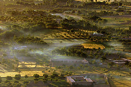
Country Afghanistan Capital Tarin Kowt - coordinates 32°48′N 66°00′E / 32.8°N 66.0°E Area 22,696 km2 (8,763 sq mi) Population 314,000 (2006) [1] Timezone UTC+4:30 Main language Pashto 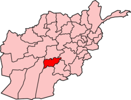 Map of Afghanistan with Oruzgan highlighted
Orūzgān or Urōzgān (Pashto: اروزګان), also spelled Uruzgan or Rōzgān (Pashto: روزګان), is one of the thirty-four provinces of Afghanistan. It is in the center of the country, though the area is culturally and tribally linked to Kandahar in the south. Its capital is Tarin Kowt. On March 28, 2004, the new Daykundi province was carved out of an area in the north leaving Oruzgan with a majority Pashtun population and Daykundi with a majority of Hazaras. The map at right shows the provincial boundaries that resulted. But in May 2006, Gizab District was taken back from Daykundi and re-annexed to Oruzgan, becoming Oruzgan's sixth district.
Contents
Geography
Oruzgan province is located in the southern region of the country having borders with Zabul and Kandahar to the south, Helmand to the southwest, Daykundi to the north and Ghazni to the east. The province covers an area of 12640 km2. Nearly three quarters of the province (72%) is mountainous or semi mountainous terrain while a little more than one-fifth (21%) of the area is made up of flat land.
Districts
Districts of Orūzgān Province District Capital Population Area[2] Notes Chora 72,000 Deh Rahwod Deh Rawood 78,750 Gizab 59,000 Khas Uruzgan 80,000 Shahidi Hassas (Cahar Chineh) 84,000 Tarin Kowt Tarin Kowt 100,000 Population figures are from the Liaison Office study 2009.[3] In addition to the above districts, it also lists Chenartu (a region in Chora district) as a separate district with a population of 30,000.
Another, separate population estimate for the entire province was an estimated population of 320,000. There are an estimated 45,000 households in the province, and households on average have 6 members.
A large portion of Oruzgan's settled population is from ethnic Pashtun tribes such as the Tarin/Tareen and it also has a population of Kuchis, or nomads, whose numbers vary with the seasons.
History
Post-2001
 US Marines travelling in Oruzgan
In June, 2002, a wedding party in Orūzgān was bombed by the United States Air Force, with 30 or more killed.[4]
In the wake of the fall of the Taliban—from January 2002 through March 2006—the province was governed by Jan Mohammed Khan, a warlord ally of President Karzai, and a member of the same Popalzai Pashtun tribe. On March 18, 2006, Karzai appointed Maulavi Abdul Hakim Munib, a former Taliban official who had reconciled with the Government of Afghanistan, to replace Khan. Munib was a Pashtun from Paktia Province.
In August 2006, NATO assumed authority for Oruzgan from the United States-led coalition, as the Netherlands took command of the PRT from the US as Task Force Uruzgan. There is also an Australian element under the Dutch command.
In the summer of 2006, insurgents in Oruzgan were targeted by a NATO-Afghan military offensive called Operation Mountain Thrust.
In September 2007, President Karzai removed Munib, who had become increasingly ineffective.
Because of security concerns and the Taliban insurgency, no international aid agencies or NGOs have a permanent presence in Oruzgan. NATO's International Security Assistance Force (ISAF) operates a Provincial Reconstruction Team (PRT), in Tarin Kowt, which transferred from U.S. to Dutch authority in August 2006. The 1,400 Dutch and 1,090 Australian troops in the area secured only the largest population centres in Oruzgan (Dihrawud, Chora, and Tarin Kowt towns) under the Dutch "inkspot policy". However, the force's Area of Responsibility included the entire province, which was not been secured. For example Gizab district, Oruzgan's most dangerous, had no ISAF presence. In August 2010, the 1,950 Dutch forces withdrew their forces from Oruzgan province, after a political disagreement in the Dutch parliament, leaving the PRT to the U.S. and Australia to continue the mission.
Oruzgan's opium poppy crop reached record levels in 2006 and 2007, according to the United Nations Office on Drugs and Crime (UNODC), as no significant eradication efforts were carried out by the Afghan administration or Dutch forces.
From June 15 to June 19, 2007 Dutch and Afghan soldiers defended the town of Chora against an assault by Taliban combatants. Reports in the Dutch, Australian [5] and US press [6][7][8] indicated that the battle was one of the largest Taliban offensives of the year. The fighting resulted in the deaths of a Dutch soldier, 16 Afghan policemen, an unknown number of civilians and a large number of Taliban.
In September 2008, Rozi Khan, the leader of Oruzgan's Pashtun Barakzai tribe, and a longtime rival of Populzai leader Jan Mohammed Khan, was killed in a firefight in Chora District.
Gīzāb province was temporarily cleared of the Taliban by ISAF forces in late April 2010 and attributed to help from the uprising of the townspeople.[9][10]
References
- ^ Afghanistan's Provinces– Uruzgan at USAID
- ^ Afghanistan Geographic & Thematic Layers
- ^ The Liaison Office, Three Years Later: A Sociopolitical Study of Uruzgun Province from 2006 to 2009
- ^ "'Scores killed' in US Afghan raid", BBC News, July 1, 2002
- ^ Aussie troops backed Dutch against Taliban | NEWS.com.au
- ^ Over 100 die in southern Afghan battle - USATODAY.com
- ^ Dutch military chief says Taliban executed civilians during fighting with NATO forces - International Herald Tribune
- ^ FOXNews.com - Over 100 Militants, Civilians and Police Killed In Massive Afghan Battle - International News | News of the World | Middle East News | Europe News
- ^ "Aussies help reclaim Afghan town", SMH, April 29, 2010
- ^ "From gunfire to governance in Gizab", ADF, April 29, 2010

Daykundi Province Ghazni Province Helmand Province 
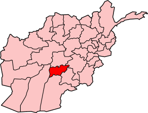
Zabul Province  Orūzgān Province

Kandahar Province Provinces of Afghanistan Badakhshan · Badghis · Baghlan · Balkh · Bamyan · Daykundi · Farah · Faryab · Ghazni · Ghor · Helmand · Herat · Jowzjan · Kabul · Kandahar · Kapisa · Khost · Kunar · Kunduz · Laghman · Logar · Nangarhar · Nimruz · Nuristan · Oruzgan · Paktia · Paktika · Panjshir · Parwan · Samangan · Sar-e Pol · Takhar · Wardak · Zabul

[[be-x-old:Урузган (правінцыя)]
Categories:


Wikimedia Foundation. 2010.