Kunduz Province

Kunduz Province

Geobox|Province
country = Afghanistan
country_

name = Kunduz
native_name = كندوز


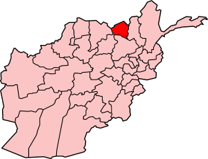
map_caption = Map of Afghanistan with Kunduz highlighted
capital = Kunduz
capital_lat_d = 36.8
capital_long_d = 68.8
population_as_of = 2002
population = 820000
area = 8040
density =
timezone = UTC+4:30
free_type = Main languages
free = Persian Turkmen Uzbek Pashto
Kunduz (PerB|كندوز) is one of the provinces of Afghanistan, centered on the city of Kunduz in Afghanistan, with an area of 8,040 km square, and a population of about 820,000 [http://www.statoids.com/uaf.html] .

The Kunduz River Valley dominates the Kunduz Province. The river flows from south to north into The Amu Darya or Oxus river which forms the border between Kunduz province and Tajikistan. A newly constructed bridge crosses the Oxus at Sher Khan. The river, its tributaries and derivative canals provide irrigation to the irrigated fields that dominate land usage in the province. There are also, rain fed fields, and open rangeland.

Districts

*Ali abad District
*Archi District
*Chahar dara District
*Imam Sahib District
*Khan Abad District
*Kunduz District
*Qalay-I-Zal District


Wikimedia Foundation. 2010.

Игры ⚽ Нужен реферат?

Look at other dictionaries:

  • Archi, Kunduz Province — Infobox Settlement official name =Archi other name = native name = nickname = settlement type = motto = imagesize = image caption = flag size = image seal size = image shield = shield size = image blank emblem = blank emblem type = blank emblem… …   Wikipedia

  • Kunduz District — is situated in the center of Kunduz Province in Northern Afghanistan, around the provincial capital the city of Kunduz. It borders with Chahar dara District to the West, Qalay I Zal and Imam Sahib districts to the North, Archi and Khan Abad… …   Wikipedia

  • Kunduz (Provinz) — Kunduz Basisdaten Staat Afghanistan …   Deutsch Wikipedia

  • Kunduz — Infobox City in Afghanistan official name = Kunduz native name = قندوز province name = Kunduz image size = image caption = latd = 36.73 longd = 68.86 districts = population total = 264100 population as of = 2006 population footnote = population… …   Wikipedia

  • Kunduz (riviere) — Kunduz (rivière) Kunduz (Daryâ ye Qondôz , Surkhab) Caractéristiques Longueur 420 km Bassin …   Wikipédia en Français

  • Kunduz (rivière) — Kunduz (Daryâ ye Qondôz , Surkhab) Caractéristiques Longueur 420 km Bassin 31 300 km2 …   Wikipédia en Français

  • Kunduz — Kondôz (province) كوندوز (Kondôz) Administration Pays Afghanistan Type Province Capitale Kondôz …   Wikipédia en Français

  • Province de Baghlan — Baghlân (province) بادغیس (Baghlân) Administration Pays Afghanistan Type Province Capitale Pol e Khomri …   Wikipédia en Français

  • Sar-e Pol Province — Coordinates: 35°36′N 66°18′E / 35.6°N 66.3°E / 35.6; 66.3 …   Wikipedia

  • Wardak Province — Coordinates: 34°24′N 68°24′E / 34.4°N 68.4°E / 34.4; 68.4 …   Wikipedia

Share the article and excerpts

Direct link
Do a right-click on the link above
and select “Copy Link”