Urgun District

Urgun District
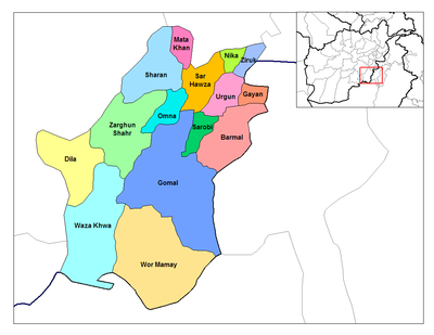
Districts of Paktika.

Urgun (Pashto: اورګون) is a district of the remote Paktika Province in Afghanistan.

Administrative seat

The administrative seat of this district is the like-named town/village of Urgun, also known as Urgun-e Kalan, meaning "Greater Urgun".

History

Urgun town used to be the provincial capital until it was replaced by Sharan in the 1970's due to its proximity to the main highway, connecting it to Kabul, Ghazni and Kandahar.

The Siege of Urgun took place between 1983 and 1984.

Demographics

The largest tribe in Urgun are the Kharoti, a sub-tribe of the Ghilzai Pashtuns. Other tribes include the Suleimankhel, Wazir and Zadran. There are also Tajiks and Uzbeks in smaller numbers.


Like many place names in Afghanistan, Urgun can be spelled a number of different ways. "Orgon" and "Urgon", however, remain the most popular alternative spellings on maps and official documents.

Urgun is 7,492 ft above sea level.

The fire base FOB Orgun-e was once home to a battalion of Infantry soldiers, who suffered casualties between 2007-2008.


Wikimedia Foundation. 2010.

Игры ⚽ Поможем решить контрольную работу

Look at other dictionaries:

  • District d'Afghanistan — Districts de Afghanistan. Les provinces d Afghanistan sont divisés en Wolaswalei (Pashto: ولسوالۍ) ou districts. Le nombre de districts en Afghanistan a fluctué au fil des ans, avec de nouveaux districts créés par scission ou fusion des parties… …   Wikipédia en Français

  • Sar Hawza District — Districts of Paktika. Sari roza or Sar Hawza (Pashto: سر هوزه) is a district of Paktika Province, Afghanistan. Overview Sarouza is one of the main districts of Paktika. Sar Hawza and Urgun District are strongholds of the Kharoti tribe …   Wikipedia

  • Nawa-I-Barakzayi District — Not to be confused with Nawa District. Coordinates: 31°22′59″N 64°18′00″E / 31.383°N 64.3°E / 31.383; 64.3 …   Wikipedia

  • Asadabad District — is one of 15 districts in Kunar Province, Afghanistan. It includes the city of Asadabad the district center, close the Kunar River. It is situated in the central part of the province. It has 12 big and small villages, which are surrounded by… …   Wikipedia

  • Chahar Dara District — (also known as Char Dara, Chahar Darreh or Char Darreh) is one of the seven districts in Kunduz Province in northern Afghanistan. It is situated in the south west part of Kunduz Province and has borders with Qalay I Zal District to the north west …   Wikipedia

  • Kandahar District — is situated in the central part of Kandahar Province, Afghanistan, surrounding the city of Kandahar. It borders with Panjwai District to the west, Arghandab District to the north, Shah Wali Kot District to the northeast and Daman District to the… …   Wikipedia

  • Nijrab District — Country Afghanistan Region Kapisa Province …   Wikipedia

  • Murghab District — For the district in Tajikistan, see Murghob district. Murghab   district   Murghab District …   Wikipedia

  • Dawlat Shah District — is located approximately 74 km from Mehterlam, the provincial centre of Laghman Province. It is a mountainous district and borders Nuristan Province to the North and North East, Alingar District to the East, Alishing District to the South… …   Wikipedia

  • Maywand District — A depiction of Maiwand during the 1878 British operations there. Maiwand District is situated in the western part of the Kandahar Province, Afghanistan. It borders Helmand Province to the west, Ghorak District to the north, Khakrez District to… …   Wikipedia

Share the article and excerpts

Direct link
Do a right-click on the link above
and select “Copy Link”