- Meherpur District
-
Meherpur — District — Location of Meherpur in Bangladesh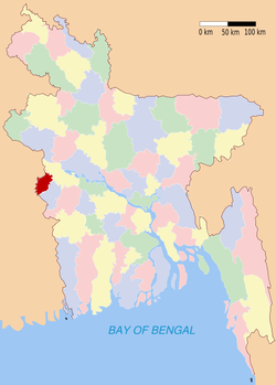
Coordinates: 23°45′N 88°42′E / 23.75°N 88.70°ECoordinates: 23°45′N 88°42′E / 23.75°N 88.70°E Country  Bangladesh
Division Khulna Division Area - Total 716.08 km2 (276.5 sq mi) Population (1991) - Total 579,531 - Density 809.3/km2 (2,096.1/sq mi) Literacy rate - Total 25.23% Time zone BST (UTC+6) - Summer (DST) BDST (UTC+7) Website Banglapedia Article Meherpur is a district in South-western Bangladesh which is also the smallest district of Bangladesh. It is a part of the Khulna Division. Before 1984, it was a part of Kushtia district. Meherpur is a historical district in Bangladesh because of the fact that the Proclamation of Independence was solemnly made at the village Baidyanathtola, Mujibnagar, on 17 April 1971. On this very day the first provisional government of Bangladesh took oath here under the leadership of Tajuddin Ahmed.
Contents
Religion
The district of Meherpur consists 1158 mosques, 456 temples, six churches and 9 tombs.
Main exports
Chilli, jute, tobacco, mango, lichy, banana, sweet potato, kachu, sugarcane molasses, etc.
Value of land
The market value of land for construction of first grade is Tk 200,000 per katha (3,000 BDT/m²), equivalent to 38 EUR/m².
Notable Places
Mujibnagar Smritishoudha, Kuthi Bari of Amjhupi, Aat Kabor of Karpasdanga.
See also
External links
 Divisions and districts of Bangladesh
Barisal Division 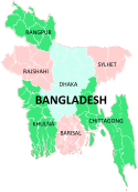
Chittagong Division Bandarban · Brahmanbaria · Chandpur · Chittagong · Comilla · Cox's Bazar · Feni · Khagrachari · Lakshmipur · Noakhali · RangamatiDhaka Division Dhaka · Faridpur · Gazipur · Gopalganj · Jamalpur · Kishoreganj · Madaripur · Manikgonj · Munshiganj · Mymensingh · Narayanganj · Narsingdi · Netrokona · Rajbari · Shariatpur · Sherpur · TangailKhulna Division Rajshahi Division Rangpur Division Sylhet Division Categories:- Meherpur District
- Districts of Bangladesh
- Bangladesh geography stubs


Wikimedia Foundation. 2010.