- Dhaka Division
-
Dhaka Division
ঢাকা বিভাগ— Division — Map of Bangladesh showing Dhaka division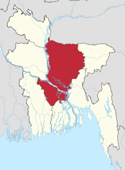
Coordinates: 24°10′N 90°25′E / 24.167°N 90.417°ECoordinates: 24°10′N 90°25′E / 24.167°N 90.417°E Country  Bangladesh
Established Area – Total 31,051 km2 (11,988.9 sq mi) Population (2011 census) – Total 46,729,000 – Density 1,504.9/km2 (3,897.7/sq mi) Time zone BST (UTC+6) Dhaka Division (Bengali: ঢাকা বিভাগ, Ḑhaka Bibhag) is an administrative division within Bangladesh. The capital and largest city is Dhaka. The division covers an area of 31,051 km², and has a population of 46,729,000 at the 2011 Census (preliminary results).
Dhaka Division is bounded by the Indian state of Meghalaya to the north, Barisal Division to the south, Chittagong Division on the south-east, Sylhet Division to the east, Rangpur Division to the north-west, and Rajshahi and Khulna Divisions to the west.
Administrative Districts
Dhaka Division, formerly Dacca Division of East Pakistan province, consists of one city corporation, 17 districts, 58 municipalities, 123 upazilas, 1,239 union parishads, 12,765 mouzas, 549 wards, 1,623 mahallas and 25,244 villages.
Name Capital Area (km²) Population
1991 CensusPopulation
2001 CensusPopulation
2011 Census
(preliminary
results)Dhaka District Dhaka 1,459.56 5,839,642 8,511,228 11,875,000 Faridpur District Faridpur 2,072.72 1,505,686 1,756,470 1,867,000 Gazipur District Gazipur 1,741.53 1,621,562 2,031,891 3,333,000 Gopalganj District Gopalganj 1,489.92 1,060,791 1,165,273 1,149,000 Jamalpur District Jamalpur 2,031.98 1,874,440 2,107,209 2,265,000 Kishoreganj District Kishoreganj 2,731.21 2,306,087 2,594,954 2,853,000 Madaripur District Madaripur 1,144.96 1,069,176 1,146,349 1,149,000 Manikganj District Manikganj 1,383.06 1,175,909 1,285,080 1,379,000 Munshiganj District Munshiganj 954.96 1,188,387 1,293,972 1,420,000 Mymensingh District Mymensingh 4,363.48 3,957,182 4,489,726 5,042,000 Narayanganj District Narayanganj 687.76 1,754,804 2,173,948 2,897,000 Narsingdi District Narsingdi 1,140.76 1,652,123 1,895,984 2,202,000 Netrokona District Netrokona 2,810.40 1,730,935 1,988,188 2,207,000 Rajbari District Rajbari 1,118.80 835,173 951,906 1,040,000 Shariatpur District Shariatpur 1,181.53 953,021 1,082,300 1,146,000 Sherpur District Sherpur 1,363.76 1,138,629 1,279,542 1,334,000 Tangail District Tangail 3,375.00 3,002,428 3,290,696 3,571,000 Total Division Dhaka 31,051.39 32,665,975 39,044,716 46,729,000 Sources
Census figures for 1991, 2001 and 2011 are from Bangladesh Bureau of Statistics, Population Census Wing. The 2011 Census figures are based on preliminary results.

Rangpur Division Meghalaya, India Sylhet Division Rajshahi Division 
 Dhaka Division

Khulna Division Barisal Division Chittagong Division  Divisions and districts of Bangladesh
Barisal Division 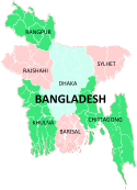
Chittagong Division Bandarban · Brahmanbaria · Chandpur · Chittagong · Comilla · Cox's Bazar · Feni · Khagrachari · Lakshmipur · Noakhali · RangamatiDhaka Division Dhaka · Faridpur · Gazipur · Gopalganj · Jamalpur · Kishoreganj · Madaripur · Manikgonj · Munshiganj · Mymensingh · Narayanganj · Narsingdi · Netrokona · Rajbari · Shariatpur · Sherpur · TangailKhulna Division Rajshahi Division Rangpur Division Sylhet Division Categories:- Bangladesh stubs
- Dhaka Division
- Divisions of Bangladesh


Wikimedia Foundation. 2010.