- Narayanganj District
-
Narayanganj
নারায়ণগঞ্জ জেলা— District — Location of Narayanganj in Bangladesh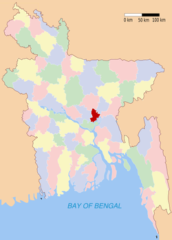
Coordinates: 23°36′N 90°30′E / 23.60°N 90.50°ECoordinates: 23°36′N 90°30′E / 23.60°N 90.50°E Country  Bangladesh
Division Dhaka Division Area – Total 759.57 km2 (293.3 sq mi) Population (2011) – Total 2,897,000 – Density 3,814/km2 (9,878.2/sq mi) Literacy rate – Total 39.84% Time zone BST (UTC+6) – Summer (DST) BDST (UTC+7) Website Banglapedia Article Narayanganj District (Bengali: নারায়ণগঞ্জ জেলা Naraeongônj Jela) is a district in central Bangladesh, part of the Dhaka Division. The main city of the district is also called Narayanganj, it is near the capital city of Dhaka. The river port of Narayanganj is one of the oldest in Bangladesh.[1] It is also a center of business and industry, especially the jute trade and processing plants, and the textile sector of the country. It is nicknamed the Dundee of Bangladesh due to the presence of lots of jute mills. Dundee was the first industrialised Juteopolis in the world.
Contents
Geography
Narayanganj District is bounded by Gazipur and Narsingdi Districts on the north, Brahmanbaria and Comilla Districts on the east, Munshiganj District on the south, and Dhaka District on the west. Geologically, the area lies on the edge of the Madhupur Tract and Holocene floodplain deposits form the aquifer. The total area of the district is 759.57 km², of which 48.56 km². is riverine and 0.60 km² is under forest. The district lies between 23°33´and 23°57´ north latitude and between 90°26´ and 90°45´ east longitude.
The city of Narayanganj has a population of 1.5 million and is located some twenty kilometres southeast of Dhaka, the national capital, on the flat Ganges Delta and alluvial plain. The Shitalakshya River divides the town into two parts, the Narayanganj Municipal Area and Kadam Rasul Municipal Area. This area is crossed by many small artificial canals fed by monsoon rain. Average annual rainfall is 2550 mm, 80 to 90% of which occurs between May and October.
The population of the division reached 2,897,000 people as of Census 2011 preliminary figures, as with all past Censuses, numbers will be revised higher once more data comes in.[2]
History
The town got its name from Bicon Lal Pandey, a Hindu religious leader who was also known as Benur Thakur or Lakhsmi Narayan Thakur. He leased the area from the British East India Company in 1766 following the Battle of Plassey. He donated the markets and the land on the banks of the river as Devottor or Given to God property, bequethed for maintenance expenses for the worship of the god Narayan.[1] A post office was set up in 1866, Narayanganj municipality was constituted on 8 September1876 and Dhaka-Narayanganj telegraph service was started from 1877. The Bank of Bengal introduced the first telephone service in 1882.
Narayanganj District was a subdivision of Dhaka district until it was up-graded to a zila on the 15 February 1984. Narayanganj, the oldest and most prominent river port in the country, became more important with the arrival of the Portuguese and the English traders during the early parts of the seventeenth and eighteenth centuries respectively. Though the west bank of Shitalakshya was an important commercial centre since the rule of Mir Jumla in the mid-seventeenth century, Narayanganj was not very busy until the beginning of the nineteenth century. The first foreign company to start trading jute in the area was the Rally Brothers, which, with the help of an Assamese company, started to export the fiber from the port to the western countries in 1830. There were 20 firms at Narayanganj in 1907-08 engaged in the purchase, bailing and supply of raw jute to Calcutta mills. Of these, 18 were in European and two in Indian ownership. With formation of Pakistan in 1947, things changed overnight. Narayanganj, which was simply a jute market, had to be converted into an industrial centre of jute. All the jute mills and presses in and around Calcutta fell to the share of India. East Pakistan was rich in the golden fibre but had no jute mill and had a very small baling capacity, which had to be increased within a short time to meet the overseas demand. The business community took up the required initiative. The Adamjees of West Pakistan came into the field at this stage and established the biggest jute mill in the world at Narayanganj. This followed establishment of a number of mills in and around Narayanganj that gave the local economy a great boost.Administrative Area
Narayanganj Zila consists of five upazilas, 47 unions and 827 mauzas. Out of the five upazilas Rupganj is the largest with an area of 247.97 km². which is 32.65% of the total area of the zila. Bandar is the smallest with an area of 55.84 km². Sharing 7.34% of the total area of the zila. All the upazilas have more or less similar characteristics.
Upazila(s)
- Araihazar, 183.5 km²., total unios 12, Mauzas 184
- Sonargaon, 171.66, km²., total unions 11, Mauzas 352
- Bandar, 55.84, km²., total unions 5, Mauzas 90
- Naryanganj Sadar, 100.75, km²., total unions 10, Mauzas 55
- Rupganj, 247.97, km²., total unions 9, Mauzas 146
- Siddirgonj,
Economy
The district is pioneer in merchandising yarn and dying items. Cottage industry like weaving is abounds in this district. International trading, Import and export business, shipyard brickfield, etc. create employment opportunities to the people which facilitate additional income to the household population.Small and medium industries of cotton are increasing day by day which fills the employment aids of peoples. The rural economy of Narayanganj is agriculture.
Religion
The district of Narayanganj consists 3078 mosques, 269 temples, ten churches and four Buddhist temples.
Places of interest
The ancient city of Sonargaon was the capital of Isa Khan, a medieval ruler of Bengal. Sonargaon is also famous for producing muslin, a delicate and fine cloth made from cotton. The Dhaka-Narayanganj-Demra (DND) embankment surrounds Narayanganj district and protects it from flooding. Narayanganj is also home to the Bangladesh Engineering and Ship Building Corporation, established in 1925 at Sonakanda on the east bank of the Shitalakshya River.
Flora and fauna
Flora
Almost the whole of Narayanganj district lies on the meander flood plain. Most of this area is now flooded only by rain-water. Only minor areas near the Lakhya. Old Brahmaputra, Meghan,shitalakha and Dhaleswari river are affected by river water and receive fresh silt deposits. A wide variety of soils occurs in this district.
Fauna
Mammals
Mammals that are commonly see in the district are Indian Pipistrelle (Pipistrellus coromandra)
Birds
the common birds of the district include Doel, Salik, Crow.duc.
Fishes
In river, canal,beels,ponds there have various kinds of fish.but because of water pollution its very hard to see fish in river.
References
See also
 Divisions and districts of Bangladesh
Barisal Division 
Chittagong Division Bandarban · Brahmanbaria · Chandpur · Chittagong · Comilla · Cox's Bazar · Feni · Khagrachari · Lakshmipur · Noakhali · RangamatiDhaka Division Dhaka · Faridpur · Gazipur · Gopalganj · Jamalpur · Kishoreganj · Madaripur · Manikgonj · Munshiganj · Mymensingh · Narayanganj · Narsingdi · Netrokona · Rajbari · Shariatpur · Sherpur · TangailKhulna Division Rajshahi Division Rangpur Division Sylhet Division Categories:


Wikimedia Foundation. 2010.