- Chittagong District
-
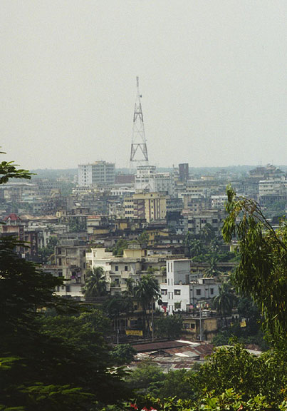
Chittagong — District — Skyline of Chittagong City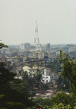 Location of Chittagong in Bangladesh
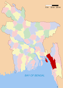
Coordinates: 22°20′15″N 91°50′20″E / 22.3375°N 91.8389°ECoordinates: 22°20′15″N 91°50′20″E / 22.3375°N 91.8389°E Country  Bangladesh
Division Chittagong Division Area - Total 5,282.98 km2 (2,039.8 sq mi) Population (2011) - Total 7,509,000 - Density 1,421.4/km2 (3,681.3/sq mi) Literacy rate - Total 43.2% Time zone BST (UTC+6) - Summer (DST) BDST (UTC+7) Chittagong District is a district located in the south-eastern region of Bangladesh. It is a part of the Chittagong Division. The port city of Chittagong, second largest city in Bangladesh, is located in this district.
Contents
History
Because of the natural harbour, Chittagong had been an important location for trade, drawing Arab traders as early as the 9th century CE. The region fell under the rule of kings from Arakan in the 16th and 17th centuries, but later, the Mughal army under Islam Khan conquered Chittagong. During the 17th century, the region also faced a lot of attacks by Portuguese pirates. The Mughals established Chittagong as a district in 1666. The Chittagong Hill Tracts were separated from Chittagong in 1860. After the liberation of Bangladesh, Cox's Bazar was separated into a district in 1984. [1]
Subdivisions
There are 14 Upazilas and 12 Thanas (under Chittagong Municipal area) under Chittagong district. The upazilas are:
- Anwara Upazila
- Banshkhali Upazila
- Boalkhali Upazila
- Chandanaish Upazila
- Fatikchhari Upazila
- Hathazari Upazila
- Lohagara Upazila
- Mirsharai Upazila
- Patiya Upazila
- Rangunia Upazila
- Raozan Upazila
- Sandwip Upazila
- Satkania Upazila
- Sitakunda Upazila
The thanas are:
- Pahartali Thana
- Panchlaish Thana
- Chittagong Kotwali Thana
- Chandgaon Thana
- Bandar Thana
- Double Mooring Thana
- Halishohor Thana
- Karnafuly Thana
- Bakoliya Thana
- Baizid Thana
- Patenga Thana
- Bhujpur Thana
Religion
The district of Chittagong consists 13148 mosques, 1025 temples, 535 Buddhist temples and 192 churches. Fakira Mosque in Hathazari, Musa Khan Mosque, Kura Katni Mosque, 16th century Kala Mosques, Chhuti Khan Mosque, Kadam Mobara Mosque, Andar Killah Mosque, Bakshi Hamid Mosque of Bashkhali are famous mosques in Chittagong. But Badar Awlia Dargah is a tomb in Chittagong.
Places of interest
Archaeological heritage and relics in Chittagong District include[1]
- Bronze statues (8th and 9th centuries, in Anwara upazila),
- Fakira Mosque (Hathazari),
- Musa Khan Mosque (1658),
- Kura Katni Mosque (1806),
- Kala Mosque (16th century),
- Chhuti Khan Mosque (Mirsharai),
- Kadam Mobarak Mosque (1719),
- Andar Killah Mosque, Wali Khan Mosque (1790),
- Badar Awlia Dargah,
- Bakshi Hamid Mosque of Banshkhali (1568),
- Chittagong Court Building (1893),
- Collegiate School, Ethnological Museum (1974).
See also
References
- ^ a b Article on Chittagong, from Banglapedia.
External links
 Divisions and districts of Bangladesh
Barisal Division 
Chittagong Division Bandarban · Brahmanbaria · Chandpur · Chittagong · Comilla · Cox's Bazar · Feni · Khagrachari · Lakshmipur · Noakhali · RangamatiDhaka Division Dhaka · Faridpur · Gazipur · Gopalganj · Jamalpur · Kishoreganj · Madaripur · Manikgonj · Munshiganj · Mymensingh · Narayanganj · Narsingdi · Netrokona · Rajbari · Shariatpur · Sherpur · TangailKhulna Division Rajshahi Division Rangpur Division Sylhet Division Categories:


Wikimedia Foundation. 2010.