- Netrokona District
-
Netrakona — District — Location of Netrakona in Bangladesh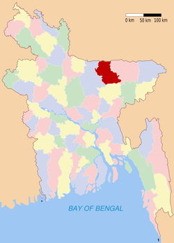
Coordinates: 24°53′N 90°44′E / 24.88°N 90.73°ECoordinates: 24°53′N 90°44′E / 24.88°N 90.73°E Country  Bangladesh
Division Dhaka Division Area – Total 2,810.40 km2 (1,085.1 sq mi) Population (2001) – Total 1,971,240 – Density 701.4/km2 (1,816.6/sq mi) Literacy rate – Total 34.94% Time zone BST (UTC+6) – Summer (DST) BDST (UTC+7) Website Banglapedia Article Netrakona is a district in central Bangladesh. It is a part of the Dhaka Division.
Contents
Geography
Netrakona District is situated in the northern part of Bangladesh. Near the Himalayan border. Historically Netrakona is the main center point of Mymensingh Githika as the view of Mahua Malua who lived there and created their performances. Netrokona Sadar Upazila has an area of 340.35 km² and it is surrounded by Durgapur and Kalmakanda upazilas on the north side, Kendua and Gauripur upazilas on the south side, Barhatta and Atpara upazilas on the east side, Purbadhala upazila on the west. There are four rivers in Netrokona. They are Kangsha, Dhala, Magra, and Teorkhali.
Netrakona Pouroshaba (Town of Netrakona) consists of 9 wards and 33 mahallas. It is a municipal town with an area of 13.63 km². Netrakona Pouroshaba was established in 1887 & Ist chairmen of Pourashaba Elahi Newas Khan(1876–1926).The town has a population of 53,853; male 51.22%, female 48.78%. The density of population is 3,951 per km². Literacy rate among the town people is 54.2%. Administration Netrakona Sadar thana was established in 1836 and was turned into an upazila in 1983. The upazila consists of 13 union parishads, 306 mouzas and 344 villages.
Upazila Of Netrakona District:
- Mohangonj
- Modon
- Khaliajuri
- Purbodhola
- Durgapur
- Kendua
- Kolmakanda
- Barhatta
- Atpara
- Netrakona Sadar
Economy
The economy of Netrakona is largely agrarian. Susang Durgapur, an Upazila of Netrokona, is one the major sources of country's China-Clay used for ceramic products. Its vast water bodies (Hawor) provides wide varieties of fish.The most of the fish collect from (Hawor) & also from rivers, the total number of river is 88 in Netrakona. Bara Bazar is the main commercial point of Netrakona.
Religion
The district of Netrokona consists 3146 mosques, 958 temples, 83 churches and eight Buddhist temples.
Places of interest
- Hazrat Shah Sultan Kamar Uddin Rumi's shrine is situated in Madanpur, a village 8 km from the district town.
- Durgapur, near the Indo-Bangla border, is a good tourist spot. The Garo Pahar is situated there and people observe time-honored traditions. People living in Netrakona's mountains are the ancestors of the Upo Jatis. The only Up-Zati cultural academi in the country is there. Khaliyajuri is a place dominated by waterways; the small villages are organised into "islands" and radio communications are poor.
Educational Institution
- Abu Abbas Degree College.http://www.abuabbasdegreecollege.net/index1.html
- Barhattacollege.http://www.barhattacollege.net/
- Sha Sultan degree mohabiddalaya.http://www.shasultandegreemohabiddalaya.net/
- N,Akanda Kamil(Master's)Madrasha
- Teligati Degree College.http://www.teligatidegreecollege.net/
- PTI, Netrokona
- Chandranath College, (proposed Banghabandu College), Amtola Road,netrakona
- Netrokona Govt. College
- Netrokona Govt. Women College
- Netrakona High School, Netrakona
- Anjuman Adarsha Govt. High School, Netrokona [1] [2]
- Datta High School
- Chandronath High School
- Jahanara Girls High School
- Md.Asaduzzaman, Netrokona
- Netrakona Adarsho Balika Bidyalaya, Netrakona
- Atpara College, Netrakona.
- Indramohan Bidyapit, East Malni, Netrakona.
- Mogra Academy, Mukterpara, Netrakona.
- Brilliant Study Center, East Malni, Netrakona.
- Netrakona Model Govt Primary School, Netrakona Sadar, Netrakona.
==Notable person :
- [[Shailoza Ronjon Mojumder*
- Late Abdul Momen, ex-Minister,A.L Leader and M.P of Bangladesh Sangsod,
- Shahabuddin Ahmed, ex-President and Chief Justice of Bangladesh
- Humayun Ahmed (Writer and Film Director. Ex Prof.of DU),
- Nirmalendu Goon (Poet),
- Begum Rokeya, Executive Director, Sabalamby Unnayan Samity, Netrakona
- Moni Singh, political Leader and organiser of Liberation War 1971),
- Kuddus Boyati, (Folk Singer)
See also
 Divisions and districts of Bangladesh
Barisal Division 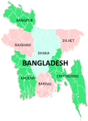
Chittagong Division Bandarban · Brahmanbaria · Chandpur · Chittagong · Comilla · Cox's Bazar · Feni · Khagrachari · Lakshmipur · Noakhali · RangamatiDhaka Division Dhaka · Faridpur · Gazipur · Gopalganj · Jamalpur · Kishoreganj · Madaripur · Manikgonj · Munshiganj · Mymensingh · Narayanganj · Narsingdi · Netrokona · Rajbari · Shariatpur · Sherpur · TangailKhulna Division Rajshahi Division Rangpur Division Sylhet Division political leader:- Shafi Ahmed
Categories:


![[1]](http://photos-f.ak.fbcdn.net/photos-ak-sf2p/v364/154/76/709804511/n709804511_831286_3607.jpg)
![[2]](http://photos-d.ak.fbcdn.net/photos-ak-sf2p/v364/154/76/709804511/n709804511_831287_3957.jpg)
Wikimedia Foundation. 2010.