- Nooksack Falls
-
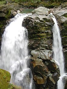
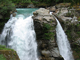
Nooksack Falls Location Mount Baker National Forest, Whatcom County, Washington, USA Coordinates 48°54′19″N 121°48′32″W / 48.90528°N 121.80889°WCoordinates: 48°54′19″N 121°48′32″W / 48.90528°N 121.80889°W Type Segmented Total height 88 feet (27 m) Number of drops 1 Longest drop 88 feet (27 m) Total width 30 feet (9.1 m) Watercourse North Fork Nooksack River Nooksack Falls is a waterfall along the North Fork of the Nooksack River in Whatcom County, Washington. The water flows through a narrow valley and drops freely 88 feet into a deep rocky river canyon. The falls are viewable from the forested cover near the cliffs edge. The falls are a short 2/3 of a mile drive off the Mount Baker Highway, Washington State Highway 542.[1] The falls were featured in the hunting scene of the movie The Deer Hunter.
Contents
History
Throughout the late 1800s, there were significant mineral discoveries being made in eastern Whatcom County and in particular the Nooksack Falls region. The richest and most significant strike was the Lone Jack Claim of 1897. Before the mine closed in 1924, approximately $500,000 worth of gold was excavated. Due to the success of the Lone Jack Claim, the area became known as the Mount Baker Mining District and produced over 5,000 claims between 1890 and 1937. One of the claims, known as the Great Excelsior Mine was located ten miles southwest of the Lone Jack Mine and only one mile from the Nooksack Falls Powerplant. In 1902, the Excelsior Claim erected a 20-stamp mill to crush the ore and a water powered turbine provided the power. In 1914, when the Excelsior Mill was rebuilt, a power line was extended from the Nooksack Falls plant to provide electricity to the mill.[2]
Hydroelectric power plant
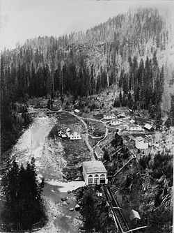
Nooksack Falls Hydroelectric Power Plant Nooksack Falls Hydroelectric Power Plant (1906)
Location: Rt. 542 on Nooksack River, Whatcom County, Washington Nearest city: Glacier, Washington Coordinates: 48°54′32″N 121°48′53″W / 48.90889°N 121.81472°W Built: 1906 NRHP Reference#: 88002735 Added to NRHP: December 15, 1988 The 1500 kilowatt capacity Hydroelectric Plant was constructed in 1906 by Stone & Webster, which is the second oldest operating facility in western Washington. The plant operated for over 90 years and ceased operation in 1997 due to a fire which destroyed the generator. The generator was replaced in 2003 and the plant resumed operations.[3]
Bellingham Bay Improvement Company
In 1889, an association of investors led by Pierre B. Cornwall formed the Bellingham Bay Improvement Company (BBIC). The company was mostly made up of wealthy California businessmen who were investing heavily into Bellingham with the vision that it would one day become an important urban center for commerce and trade. The BBIC invested in several diverse enterprises such as shipping, coal, mining, railroad construction, real estate sales and utilities. Even though their dreams of turning Bellingham into a Pacific Northwest metropolis never came to fruition, the BBIC made an immense contribution to the economic development of Bellingham. The BBIC had the franchise for providing electricity to the city of Bellingham, which at that time primarily went to street lighting and electric streetcars. However, by 1903 the small generator powering Bellingham was proving to be inadequate for the growing city. The BBIC began developing a hydroelectric plant on the North Fork of the Nooksack River, below Nooksack Falls.[2]
In 1904, the BBIC's electrical franchise with the city of Bellingham was up for renewal and the city council made it abundantly clear that they were not happy with BBIC's performance up to this point. The city event threatened to build a municipally owned hydroelectric plant at Whatcom Falls. After a survey showing that BBIC was supplying Bellingham with cheaper power than any of the municipal proposals, the city subsequently backed off.[2]
In addition to the hostility felt by the city council, the BBIC was also encountering construction problems at Nooksack Falls. In 1903 the BBIC had bored six tunnels, yet the generator and transformers for the plant were waiting fifty miles away. Moving heavy hydroelectric equipment through the mountains to the Nooksack site proved to be a challenge. The heaviest equipment ended up being shipped to the railhead at Glacier, loaded on a sled and pulled through the mountains. The first piece of heavy equipment to be brought in was a crane with a forty thousand pound capacity. Lighter equipment and parts were brought in by pack animals. Many local residents were paid to lease out their animals. However, all the difficulties of maintaining a generator and trying to construct the Nooksack Site took its toll on BBIC. In 1905 the board of directors announced the sale of its utility holdings.[4]
Stone & Webster
In 1905, Stone & Webster bought out the power and lighting properties that were once owned by the BBIC. These included the York Street Steam plant and the partially built Nooksack Falls Hydroelectric Power Plant. Stone & Webster took over construction operations and on September 21, 1906, Bellingham received power from the plant via a 47 mile long transmission line.[5]
For much of the plant's history, it served as the center of a small community. Because of its remote location, rugged landscape, and primitive transportation, the only practical way to operate the plant was to have employees on site. The utility company employed one chief-operator, two assistant operators and housed them in three frame cottages. In addition, a school teacher was hired to tutor children. A two story wood frame hotel was built around 1905 to house company officials, construction workers and other visitors. A section of the hotel was used as a classroom. Employment for the plant reached its peak between 1906 and the mid 1920s. Once the plant became automated by 1978, the cottages were demolished in order to discourage squatters from living there.[6]
The Power Plant was placed on The National Register of Historic Places on December 15, 1988.[7]
References
- ^ Tabor, Rowland W., and Haugerud, Ralph (1999). Geology of the North Cascades: A Mountain Mosaic, p. 88. Seattle: The Mountaineers Books. ISBN 0898866235.
- ^ a b c Library Of Congress
- ^ Library Of Congress Report
- ^ Library Of Congress
- ^ Library Of Congress
- ^ Library Of Congress
- ^ National Register of Historical Places – Washington, Whatcom County
External links
- Photos from the Historic American Buildings Survey
- U.S. Geological Survey Geographic Names Information System: Nooksack Falls
U.S. National Register of Historic Places Topics Lists by states Alabama • Alaska • Arizona • Arkansas • California • Colorado • Connecticut • Delaware • Florida • Georgia • Hawaii • Idaho • Illinois • Indiana • Iowa • Kansas • Kentucky • Louisiana • Maine • Maryland • Massachusetts • Michigan • Minnesota • Mississippi • Missouri • Montana • Nebraska • Nevada • New Hampshire • New Jersey • New Mexico • New York • North Carolina • North Dakota • Ohio • Oklahoma • Oregon • Pennsylvania • Rhode Island • South Carolina • South Dakota • Tennessee • Texas • Utah • Vermont • Virginia • Washington • West Virginia • Wisconsin • WyomingLists by territories Lists by associated states Other  Category:National Register of Historic Places •
  Portal:National Register of Historic Places
Waterfalls of the North Cascades of Washington Bacon Peak • Berdeen • Blum Basin • Boston Creek • Colonial Creek • Cloudcap • Depot Creek • Depot Valley • Green Lake • Jordan Creek • Mazama • Nooksack • Rainy Lake• Rockflow Canyon • Seahpo Peak • Roush Creek • Sholes Creek • Sulphide Creek • Torment • Wells Creek •
Categories:- National Register of Historic Places in Washington (state)
- Nooksack
- Waterfalls of Washington (state)
- Landforms of Whatcom County, Washington
- Hydroelectric power plants in Washington (state)
Wikimedia Foundation. 2010.


