- Orting, Washington
-
Orting — City — City of Orting Location of Orting, Washington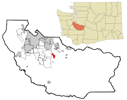
Coordinates: 47°5′46″N 122°12′19″W / 47.09611°N 122.20528°WCoordinates: 47°5′46″N 122°12′19″W / 47.09611°N 122.20528°W Country United States State Washington County Pierce Government – Mayor Cheryl Temple Area – Total 2.7 sq mi (7.1 km2) – Land 2.7 sq mi (7.1 km2) Elevation 190 ft (58 m) Population (2010) – Total 6,746 – Density 2,460.9/sq mi (950.1/km2) Time zone Pacific (PST) (UTC-8) – Summer (DST) PDT (UTC-7) ZIP code 98360 Area code(s) 360 FIPS code 53-52005[1] GNIS feature ID 1512539[2] Website Official website Orting is a city in Pierce County, Washington, United States. The population as of the 2010 census is 6,746, according to the City of Orting.
Contents
History
Orting is a small city located approximately 30 miles (48 km) from Mount Rainier. The first recorded claims for the land in Orting were made in 1854 by William Henry Whitesell (also the first postmaster), Thomas Headley, Daniel Lane and Daniel Varner. These 4 people all have streets in the city named after them, plus a monument in the Orting City Park commemorating them. The city was officially incorporated on April 22, 1889. Early growth came as the area developed fields to grow hops, produce, and logging industries. Later Christmas tree and bulb farms became important to the local economy. Orting was also a supply town for the coal mining towns of Wilkeson and Carbonado. The first railroad in the city was built in 1877. It was called "Whitesell's Crossing" because the railroad ran right through the Whitesell property. Population rose quickly after this railroad was built, as it made transportation in and out of the city much easier. What's left of the Railroad is now the Meeker Southern Railroad which runs between Puyallup and McMillin
Foothills Trail
The Foothills Trail is a paved trail built on the old railroad bed. It runs through Orting, to South Prairie in one direction and to Sumner in the other. Its primary function is recreation, however it is also utilized by many commuters on bicycles. The trail is for walking, bicycling, horseback riding, skating and skateboarding and scooter traffic. It is set aside for nonmotorized vehicles only.
Salmon fishing
Orting is nestled between the Carbon and Puyallup Rivers. The Voights Creek Hatchery is located just outside of Orting and plays a large part in the healthy runs of salmon that bring fishermen from far and wide to enjoy the challenge of landing a big salmon.
Washington State Soldiers Home
Orting is home to the beautiful historic buildings and park like grounds that facilitate all levels of care and housing for soldiers. The soldiers cemetery, on the hill just above the Soldiers Home, is filled with a history of our nation with gravestones for soldiers dating back to service in the Civil War. The Soldiers Home is located on the Orting Kapowsin Hwy and can be reached by leaving Orting on Calistoga and heading toward Graham where it can be found at the base of the hill.
City parks and murals
Orting is known for its beautiful parks filled with huge shade trees making it a place for picnics and relaxing right in the center of the historic downtown area. Visitors will enjoy the Saturday Market in the North Park, 9 am – 2 pm in July and August. A walking tour map is available at the library on the corner of Train and Washington. The map shows the route to the historic murals scattered on buildings throughout the town. Throughout town there are views of Mt. Rainier shining in the distance.
Daffodil Parade
Every year, Orting is the fourth and final stop in the annual Daffodil Festival Parade. The parade has gone through downtown Orting since 1934. It draws over 10,000 people in early April to the festivities in the downtown Orting Parks and the parade viewing in late afternoon. The parade also goes through the cities of Tacoma, Puyallup, and Sumner.
Mount Rainier
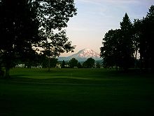 Mount Rainier as seen from the High Cedars Golf Course in Orting, bordering the Carbon River
The town sits in a fertile valley between two major rivers, the Carbon and Puyallup Rivers, and it is built entirely on several layers of lahar deposits. Based on past lahar flow and the structure of Mount Rainier, Orting has been designated the most at-risk town in the event of lahar activity from the mountain. Scientists predict that lahars could reach Orting in as little as 30 minutes from origin. Authorities have installed a system of lahar sirens throughout the area, activated by sensors on Mt. Rainier. The local schools regularly stage lahar evacuation drills, and residents have been informed as to lahar escape routes. The city is progressing toward building "Bridge for Kids", a walking bridge across the Carbon River that could be used for recreation and rapid evacuation up the hill toward Cascadia.[3]
Geography
Orting is located at 47°5′46″N 122°12′19″W / 47.09611°N 122.20528°W (47.096071, -122.205401).[4]
According to the United States Census Bureau, the city has a total area of 2.7 square miles (7.1 km²), all land.
Transportation
The primary way of reaching the city by car is Washington State Route 162. There is also an Orting bus, called the Orting Loop, that provides bus transportation between Orting and Puyallup, Washington.
Education
Education in the city of Orting is provided by the Orting School District. There are currently 5 schools in operation.
- Orting Primary School (grades K–2)
- Ptarmigan Ridge Intermediate School (grades 3–5)
- Orting Middle School (grades 6–8)
- Orting High School (grades 9–12)
Demographics
Historical populations Census Pop. %± 1890 623 — 1900 728 16.9% 1910 799 9.8% 1920 972 21.7% 1930 1,109 14.1% 1940 1,211 9.2% 1950 1,299 7.3% 1960 1,520 17.0% 1970 1,643 8.1% 1980 1,763 7.3% 1990 2,106 19.5% 2000 3,760 78.5% 2010 6,746 79.4% As of the census[1] of 2000, there were 3,760 people, 1,318 households, and 999 families residing in the city. The population density was 1,372.2 people per square mile (529.8/km²). There were 1,382 housing units at an average density of 504.4 per square mile (194.7/km²). The racial makeup of the city was 92.37% White, 0.61% African American, 0.98% Native American, 1.25% Asian, 0.27% Pacific Islander, 1.28% from other races, and 3.24% from two or more races. Hispanic or Latino of any race were 3.43% of the population.
There were 1,318 households out of which 44.4% had children under the age of 18 living with them, 60.5% were married couples living together, 10.7% had a female householder with no husband present, and 24.2% were non-families. 18.7% of all households were made up of individuals and 7.4% had someone living alone who was 65 years of age or older. The average household size was 2.85 and the average family size was 3.26.
In the city the population was spread out with 32.8% under the age of 18, 7.3% from 18 to 24, 36.8% from 25 to 44, 14.4% from 45 to 64, and 8.8% who were 65 years of age or older. The median age was 30 years. For every 100 females there were 103.6 males. For every 100 females age 18 and over, there were 95.4 males.
The median income for a household in the city was $53,464, and the median income for a family was $55,335. Males had a median income of $41,486 versus $26,438 for females. The per capita income for the city was $18,951. About 4.2% of families and 6.5% of the population were below the poverty line, including 5.2% of those under the age of 18 and 15.8% of those 65 and older.
References
- ^ a b "American FactFinder". United States Census Bureau. http://factfinder.census.gov. Retrieved 2008-01-31.
- ^ "US Board on Geographic Names". United States Geological Survey. 2007-10-25. http://geonames.usgs.gov. Retrieved 2008-01-31.
- ^ [1]
- ^ "US Gazetteer files: 2010, 2000, and 1990". United States Census Bureau. 2011-02-12. http://www.census.gov/geo/www/gazetteer/gazette.html. Retrieved 2011-04-23.
External links
Municipalities and communities of Pierce County, Washington Cities 
Towns Carbonado | Eatonville | Ruston | South Prairie | Steilacoom | Wilkeson
CDPs Artondale | Ashford | Elbe | Elk Plain | Fort Lewis | Fox Island | Frederickson | Graham | Greenwater | McChord AFB | Midland | Parkland | Prairie Ridge | South Hill | Spanaway | Summit | Waller
Unincorporated
communitiesAnderson Island | Browns Point | Burnett | Cascadia | Dash Point | Herron Island | Home | Kapowsin | Ketron Island | La Grande | Lakebay | Longbranch | McKenna | McNeil Island | Paradise | Purdy | Vaughn | Wauna
Indian reservations Ghost towns Fairfax | Melmont
Footnotes ‡This populated place also has portions in an adjacent county or counties
Categories:- Cities in Washington (state)
- Populated places in Pierce County, Washington
- Old soldiers' homes in the United States


Wikimedia Foundation. 2010.