- Mount Rainier Volcano Lahar Warning System
-
The Mount Rainier Volcano Lahar Warning System is a loose-knit, emergency notification and warning system developed by the United States Geological Survey in 1998, and now operated by the Pierce County Department of Emergency Management and several cities . It is supposed to assist in the evacuation of the Puyallup River Valley in Washington state in the event of a volcanic eruption from Mt. Rainier.
Contents
History
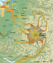 Hazard map
Mount Rainier, an active volcano in Washington state which last erupted in 1882, has occasionally buried sections of the Puyallup River valley in volcanic mudflow. Currently, more than 100,000 people live on the deposits of Mount Rainier lahars that have occurred within the last 6,000 years.[1] Geologists consider Mount Rainier the most dangerous mountain in the United States, [2] and the Geological Survey has estimated there is a 1-in-7 chance of a catastrophic lahar at Mount Rainier occurring in the next 75 years. [3]
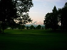 Mount Rainier as seen from the High Cedars Golf Course in Orting, bordering the Carbon River
The Pacific Northwest Seismic Network (PNSN), operated by the University of Washington, provides continuous monitoring of seismic activity in the area and is intended to provide first indication of volcanic unrest at Mount Rainier. However, while the PNSN is able to detect that a lahar-generating event has occurred, it is not able to determine the location or flow of debris. Beginning in 1998 a lahar-detection system consisting of five acoustic flow monitors was installed around Mount Rainier which would help identify the speed and direction of a lahar. Comprehensive coverage, which would require 30 to 40 such monitors, has yet to be installed.[4]
Since 2000, the nascent lahar detection system has been operated by the Pierce County Department of Emergency Management which also has responsibility for coordination of public information and evacuation of areas of potential impact. Tacoma, at the mouth of the Puyallup, is only 37 miles (60 km) west of Mount Rainier, and moderately sized towns such as Puyallup and Orting are only 27 and 20 miles (43 and 32 km) away, respectively.
Components
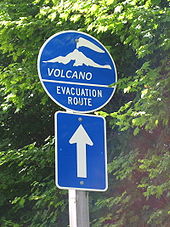 One of many emergency evacuation route signs in case of volcanic eruption or lahar around Mt. Rainier
Current
Local governmental authorities would be notified of a lahar-generating event by staff at the Pacific Northwest Seismic Network. Confirmation and direction of the lahar would be received from information generated by acoustic flow monitors positioned around Mount Rainier and analyzed by a computer maintained by Pierce County, at which time a localized or general evacuation of the Puyallup River Valley could be ordered. It is estimated residents of areas that could potentially be effected by a lahar would have one hour or less to evacuate.[4]
The public alert component of the warning system is composed of a network of 26 sirens owned by the municipalities in which they are located.[1] The sirens are augmented by a Reverse 911 system maintained by the county and a dedicated emergency management radio station broadcasting at 1580AM.[5] Directional signs in the area of potential impact are posted along pre-designated evacuation routes.
Planned
As of 2009 Pierce County was in the process of linking the county's warning sirens via satellite which would enable centralized activation of the alarms by county officials and mitigate the possibility that some might not sound in the event of a lahar, a problem encountered during tests. Plans to outfit 35 of the county's roadside evacuation signs with LED's that could be illuminated during a volcanic event are also being evaluated.[6]
Problems
- In semi-annual tests of the warning system, more than twenty percent of the sirens have periodically failed to sound the alarm tones. During a 2007 test, the dedicated emergency broadcaster - 1580AM - failed to switch automatically to the prerecorded warning message, forcing officials to switch the station's programming manually.[5]
- During a 2006 test of the Emergency Alert System in Washington state, operator error resulted in the transmission of a volcano alert to broadcast stations. The alert, which was not corrected for 41 minutes, was carried over-the-air by KELA-AM.
Cultural references
- An episode in the 2006 History Channel series Mega Disasters, titled "American Volcano", was about the impacts of a catastrophic lahar resulting from the eruption of Mount Rainier.
- An episode of It Could Happen Tomorrow discusses what would happen if Mount Rainier erupted and caused a lahar.
References
- ^ a b http://www.co.pierce.wa.us/pc/Abtus/ourorg/dem/EMDiv/VHRP/I.htm
- ^ Rainier: Danger at our door [1], Seattle Times, May 16, 2000, Accessed March 8, 2009.
- ^ 5 Natural Disasters Headed for the United States [2], Popular Mechanics, October 2006, Accessed March 8, 2009.
- ^ a b http://www.co.pierce.wa.us/pc/Abtus/ourorg/dem/EMDiv/VHRP/V.htm
- ^ a b System to warn of Mount Rainier lahars shows gaps [3], Seattle Post-Intelligencer, May 3, 2007, Accessed March 10, 2009.
- ^ County debuts lahar sirens that all turn on at once [4], The News Tribune, October 22, 2008, Accessed March 8, 2009.
- ^ Worker hits wrong buttong, sends out lahar warning [5], Seattle Post-Intelligencer, May 27, 2006, Accessed March 10, 2009.
Categories:- Civil defense
- Disaster preparedness in the United States
- Emergency management
- Emergency Alert System
- Volcanoes of Washington (state)


Wikimedia Foundation. 2010.